

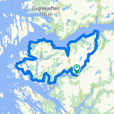
Rock cycling in Haugsdalen and Engleberget
Una ruta en bici que comienza en Mo, Hordaland Fylke, Noruega.
Visión General
Sobre esta ruta
Esta es una ruta con senderos técnicos y algunos 'playgrounds' para ciclismo en roca.
Ve hasta el final del camino de construcción en Svartavanet en el valle de Haugsdalen. Puedes ir en bici, en coche o tomar el telesilla desde Matre, a una hora al norte de Bergen.
Baja y gira a la izquierda. Sigue un sendero técnico y luego tu propio camino por la naturaleza y sobre rocas hacia la carretera. Sigue la carretera 700 m hacia atrás y gira a la izquierda. Sal de la carretera justo antes del puente, y tendrás un 'playground' de roca suave frente a ti. Puedes seguir ambos lados del río, pero normalmente cruzo el río a poca distancia debajo del puente y sigo por el lado derecho.
Dependiendo del nivel del agua en el lago, cruzas por el lado norte del lago. Si está lleno, quizás sea más fácil subir la colina. Normalmente continúas hacia un nuevo 'playground' con rocas suaves hasta que llegas a la carretera.
Sigue la carretera 2 km hacia el sur donde es posible hacer un pequeño desvío a la izquierda.
Luego, 300 m más adelante, sal de la carretera nuevamente, y el 'playground' en Engleberget está frente a ti. Encuentra tu camino entre las rocas hasta el lago. Sigue por el lado izquierdo/este alrededor del lago. En la parte interior eliges el nivel de dificultad para jugar.
En la última parte de regreso a la carretera hay rocas planas y lisas.
Se recomienda encarecidamente una bicicleta de suspensión total. Alquiler: www.bergfritid.no
- -:--
- Duración
- 11,5 km
- Distancia
- 557 m
- Ascenso
- 694 m
- Descenso
- ---
- Velocidad Media
- ---
- Altitud máxima

Continuar con Bikemap
Usa, edita o descarga esta ruta en bici
¿Te gustaría recorrer Rock cycling in Haugsdalen and Engleberget o personalizarla para tu propio viaje? Esto es lo que puedes hacer con esta ruta de Bikemap:
Funciones gratuitas
- Guarda esta ruta como favorita o en una colección
- Copia y planifica tu propia versión de esta ruta
- Sincroniza tu ruta con Garmin o Wahoo
Funciones Premium
Prueba gratuita de 3 días o pago único. Más información sobre Bikemap Premium.
- Navega esta ruta en iOS y Android
- Exporta un archivo GPX / KML de esta ruta
- Crea tu impresión personalizada (pruébala gratis)
- Descarga esta ruta para la navegación sin conexión
Descubre más funciones Premium.
Consigue Bikemap PremiumDe nuestra comunidad
Mo: Otras rutas populares que empiezan aquí
 BF3 Anleggsveien Stordalen
- Distancia
- 10,6 km
- Ascenso
- 355 m
- Descenso
- 440 m
- Ubicación
- Mo, Hordaland Fylke, Noruega
 Stølsheimen Vest: Fjordsykkelruta
- Distancia
- 217,5 km
- Ascenso
- 2041 m
- Descenso
- 2041 m
- Ubicación
- Mo, Hordaland Fylke, Noruega
 BF5 Matre Bjordal Ortnevik
- Distancia
- 59,4 km
- Ascenso
- 3145 m
- Descenso
- 3126 m
- Ubicación
- Mo, Hordaland Fylke, Noruega
 Stordalen: Anleggsveien
- Distancia
- 10,6 km
- Ascenso
- 263 m
- Descenso
- 348 m
- Ubicación
- Mo, Hordaland Fylke, Noruega
 Stølsheimen Vest: Fjordsykkelruta
- Distancia
- 217,5 km
- Ascenso
- 1751 m
- Descenso
- 1735 m
- Ubicación
- Mo, Hordaland Fylke, Noruega
 Stølsheimen Vest
- Distancia
- 152,3 km
- Ascenso
- 1505 m
- Descenso
- 1504 m
- Ubicación
- Mo, Hordaland Fylke, Noruega
 BF7 Matre Slovag
- Distancia
- 45,2 km
- Ascenso
- 1310 m
- Descenso
- 1690 m
- Ubicación
- Mo, Hordaland Fylke, Noruega
 BF6 Matre Solund
- Distancia
- 95,4 km
- Ascenso
- 1801 m
- Descenso
- 2181 m
- Ubicación
- Mo, Hordaland Fylke, Noruega
Ábrela en la app