

The Ladywell Way - Motherwell to Hillend Reservoir
Una ruta en bici que comienza en Motherwell, Escocia, Reino Unido.
Visión General
Sobre esta ruta
Aparte del tramo urbano ocupado al comienzo hacia Newhouse, este camino te lleva a las grandes tierras de la naturaleza salvaje con caminos de pantano y lagos aislados.
Descripción detallada a continuación
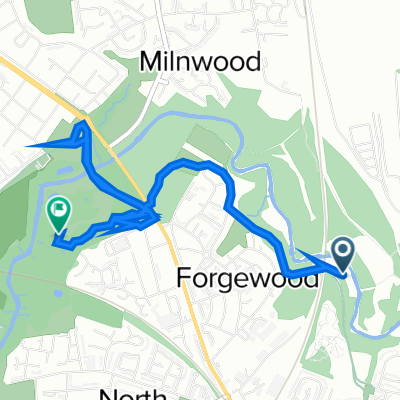
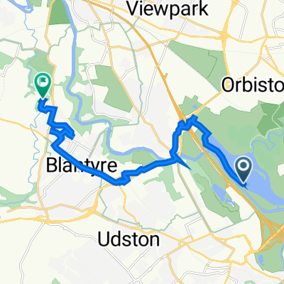
Esta sección de la naturaleza baja comienza en la Catedral de Motherwell. Se recomienda hacer un breve desvío hacia la piedra de Ladywell en la carretera Ladywell, y los orígenes del nombre de Motherwell. Luego, avanza a través de áreas urbanas en una carretera concurrida con acera. Después de 3 km, llega a la famosa gruta de Carfin. Luego continúa por la carretera con acera a través de Newarthill otros 4 km hasta Newhouse. (Este es un punto de inicio alternativo si deseas evitar el tramo urbano desde Motherwell). Continúa a lo largo de la acera y la carretera durante un kilómetro y medio y gira a la izquierda en una tranquila carretera cercada durante un kilómetro, pasando por debajo de la autopista, luego continúa un kilómetro girando a la izquierda en Blackridge Farm y sube hasta el bosque en Easter Dunsyston. Gira a la derecha por el camino hasta la cantera y luego a la derecha de nuevo en la pista a lo largo del lado norte del embalse de Roughrigg, dirigiéndote hacia las antenas de radio en Black Hill, hasta que te unas a una carretera tranquila, Duntilland Road, en Mountcow.
Continúa hacia el noroeste por la carretera durante 1½ kilómetros y luego toma la pista señalizada Lilly Loch a 1 milla. En Lilly Loch, toma la pista que rodea el extremo oriental del lago, que te lleva al destino en el embalse de Hillend.
Hotel etc. en Newhouse, pero luego sin instalaciones hasta el embalse de Hillend y el cercano pueblo de Caldercruix.
Esta es la 1ª sección del gran camino de peregrinos, el Ladywell Way, desde Motherwell en Lanarkshire hasta el Puente de Forth y luego a St Andrews.
Para otras grandes rutas de peregrinación, visita el sitio web: http://www.thewayofstandrews.com/
- -:--
- Duración
- 17,3 km
- Distancia
- 268 m
- Ascenso
- 147 m
- Descenso
- ---
- Velocidad Media
- 267 m
- Altitud máxima

Calidad de la ruta
Tipos de vía y superficies a lo largo de la ruta
Tipos de vía
Carretera tranquila
4,7 km
(27 %)
Camino forestal
2,9 km
(17 %)
Superficies
Pavimentado
1,9 km
(11 %)
Sin pavimentar
2,1 km
(12 %)
Suelo
1,4 km
(8 %)
Pavimentado (sin definir)
1,2 km
(7 %)
Destacados de la ruta
Puntos de interés a lo largo de la ruta
Punto de interés después de 3,3 km
Carfin Grotto 100 Newarthill Road, Motherwell, United Kingdom 01698 263308

Punto de interés después de 11,3 km
Former Quarry
Punto de interés después de 14 km
Joins quiet tarmac road

Punto de interés después de 16,4 km
Lilly Loch
Continuar con Bikemap
Usa, edita o descarga esta ruta en bici
¿Te gustaría recorrer The Ladywell Way - Motherwell to Hillend Reservoir o personalizarla para tu propio viaje? Esto es lo que puedes hacer con esta ruta de Bikemap:
Funciones gratuitas
- Guarda esta ruta como favorita o en una colección
- Copia y planifica tu propia versión de esta ruta
- Sincroniza tu ruta con Garmin o Wahoo
Funciones Premium
Prueba gratuita de 3 días o pago único. Más información sobre Bikemap Premium.
- Navega esta ruta en iOS y Android
- Exporta un archivo GPX / KML de esta ruta
- Crea tu impresión personalizada (pruébala gratis)
- Descarga esta ruta para la navegación sin conexión
Descubre más funciones Premium.
Consigue Bikemap PremiumDe nuestra comunidad
Motherwell: Otras rutas populares que empiezan aquí
 Watling Street
- Distancia
- 13,1 km
- Ascenso
- 104 m
- Descenso
- 104 m
- Ubicación
- Motherwell, Escocia, Reino Unido
 Dalriada Crescent 156 to Forbes Drive 9
- Distancia
- 4 km
- Ascenso
- 214 m
- Descenso
- 209 m
- Ubicación
- Motherwell, Escocia, Reino Unido
 The Ladywell Way - Motherwell to Hillend Reservoir
- Distancia
- 33 km
- Ascenso
- 340 m
- Descenso
- 339 m
- Ubicación
- Motherwell, Escocia, Reino Unido
 Recovered Route
- Distancia
- 11 km
- Ascenso
- 211 m
- Descenso
- 223 m
- Ubicación
- Motherwell, Escocia, Reino Unido
 Prospect Hill Road 6 to Merry Street 545
- Distancia
- 3,4 km
- Ascenso
- 36 m
- Descenso
- 32 m
- Ubicación
- Motherwell, Escocia, Reino Unido
 North-Holytown-The Craig- Strathy-Home
- Distancia
- 21,2 km
- Ascenso
- 151 m
- Descenso
- 151 m
- Ubicación
- Motherwell, Escocia, Reino Unido
 Woodlands Road 31 to M74
- Distancia
- 9,7 km
- Ascenso
- 92 m
- Descenso
- 144 m
- Ubicación
- Motherwell, Escocia, Reino Unido
 Motherwell West Ward, North Lanarkshire to 72 Kirkwall Ave, Glasgow
- Distancia
- 10,9 km
- Ascenso
- 90 m
- Descenso
- 78 m
- Ubicación
- Motherwell, Escocia, Reino Unido
Ábrela en la app