
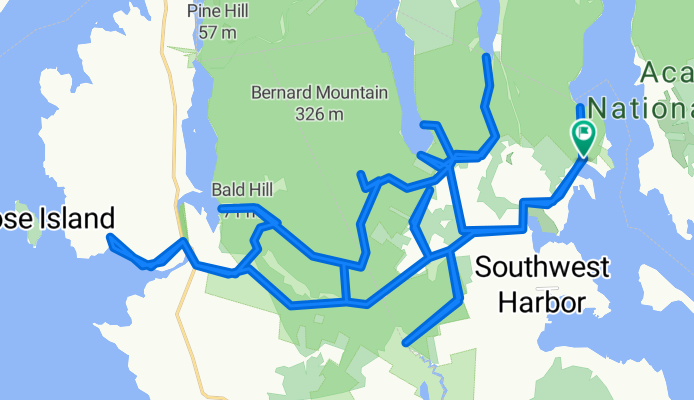
Western side of Acadia
Una ruta en bici que comienza en Tremont, State of Maine, United States of America.
Visión General
Sobre esta ruta
This route travels on about 65% dirt roads (with a short section of non-technical trail riding), and 35% pavement, and there is a short non-technical trail section. A number of these dirt roads are one lane and are out in a thick forest, with green moss making up the forest bed. It's really nice on a sunny day.
On Cape Road there are a few picnic tables near a small harbor and boat launch. There is a great view here while snacking on the Clif Bar. About 2/3rds way through is a fire road that takes you to the southernmost point. It ends at a small body of water that eventually becomes Bass Harbor. It's in the middle of nowhere. Parking it at the trail head for Flying Mtn.- -:--
- Duración
- 44,7 km
- Distancia
- 420 m
- Ascenso
- 420 m
- Descenso
- ---
- Velocidad Media
- ---
- Altitud máxima
Calidad de la ruta
Tipos de vía y superficies a lo largo de la ruta
Tipos de vía
Carretera tranquila
27,1 km
(61 %)
Carretera de acceso
5,9 km
(13 %)
Superficies
Pavimentado
4 km
(9 %)
Sin pavimentar
15,1 km
(34 %)
Sin asfaltar (sin definir)
15,1 km
(34 %)
Asfalto
4 km
(9 %)
Sin definir
25,5 km
(57 %)
Destacados de la ruta
Puntos de interés a lo largo de la ruta
Punto de interés después de 25,4 km
Picnic table with a great view while chewing on the Clif Bar.
Continuar con Bikemap
Usa, edita o descarga esta ruta en bici
¿Te gustaría recorrer Western side of Acadia o personalizarla para tu propio viaje? Esto es lo que puedes hacer con esta ruta de Bikemap:
Funciones gratuitas
- Guarda esta ruta como favorita o en una colección
- Copia y planifica tu propia versión de esta ruta
- Sincroniza tu ruta con Garmin o Wahoo
Funciones Premium
Prueba gratuita de 3 días o pago único. Más información sobre Bikemap Premium.
- Navega esta ruta en iOS y Android
- Exporta un archivo GPX / KML de esta ruta
- Crea tu impresión personalizada (pruébala gratis)
- Descarga esta ruta para la navegación sin conexión
Descubre más funciones Premium.
Consigue Bikemap PremiumDe nuestra comunidad
Tremont: Otras rutas populares que empiezan aquí
 round mini mound
- Distancia
- 6,6 km
- Ascenso
- 103 m
- Descenso
- 100 m
- Ubicación
- Tremont, State of Maine, United States of America
 Around Mountain & 7 Bridges
- Distancia
- 24,1 km
- Ascenso
- 26 m
- Descenso
- 22 m
- Ubicación
- Tremont, State of Maine, United States of America
 Around Mountain 7 Bridges
- Distancia
- 24,2 km
- Ascenso
- 0 m
- Descenso
- 3 m
- Ubicación
- Tremont, State of Maine, United States of America
 Route from 26 Harborside Rd, Mount Desert
- Distancia
- 4 km
- Ascenso
- 153 m
- Descenso
- 90 m
- Ubicación
- Tremont, State of Maine, United States of America
 USBR1 via 1A Southwest Harbor to Portland
- Distancia
- 304,2 km
- Ascenso
- 620 m
- Descenso
- 631 m
- Ubicación
- Tremont, State of Maine, United States of America
 southwest harbor to cadillac mt and back
- Distancia
- 47,2 km
- Ascenso
- 593 m
- Descenso
- 602 m
- Ubicación
- Tremont, State of Maine, United States of America
 249–251 Sound Dr, Mount Desert to 253–263 Sound Dr, Mount Desert
- Distancia
- 18,5 km
- Ascenso
- 294 m
- Descenso
- 282 m
- Ubicación
- Tremont, State of Maine, United States of America
 Western side of Acadia
- Distancia
- 44,7 km
- Ascenso
- 420 m
- Descenso
- 420 m
- Ubicación
- Tremont, State of Maine, United States of America
Ábrela en la app