
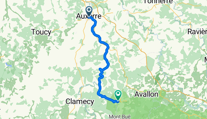
Camino 2015 10 Auxerre nach Vezelay
Una ruta en bici que comienza en Auxerre, Borgoña-Franco Condado, Francia.
Visión General
Sobre esta ruta
desde km 42 hasta km 51, pendiente cada vez más pronunciada (130 hm)desde km 53 hasta km 55, 40 hm de ascensoluego bajada pronunciadaantes de Vezelay, otra subidaHotel Le Compostelle1 Place du Champ de Foire,89450 Vezelay,Tel:+33 3 86 33 28 63
- -:--
- Duración
- 58,3 km
- Distancia
- 299 m
- Ascenso
- 168 m
- Descenso
- ---
- Velocidad Media
- ---
- Altitud máxima

Calidad de la ruta
Tipos de vía y superficies a lo largo de la ruta
Tipos de vía
Carril bici
19,8 km
(34 %)
Carretera tranquila
7,6 km
(13 %)
Superficies
Pavimentado
42,6 km
(73 %)
Sin pavimentar
0,6 km
(1 %)
Asfalto
41,4 km
(71 %)
Pavimentado (sin definir)
1,2 km
(2 %)
Continuar con Bikemap
Usa, edita o descarga esta ruta en bici
¿Te gustaría recorrer Camino 2015 10 Auxerre nach Vezelay o personalizarla para tu propio viaje? Esto es lo que puedes hacer con esta ruta de Bikemap:
Funciones gratuitas
- Guarda esta ruta como favorita o en una colección
- Copia y planifica tu propia versión de esta ruta
- Sincroniza tu ruta con Garmin o Wahoo
Funciones Premium
Prueba gratuita de 3 días o pago único. Más información sobre Bikemap Premium.
- Navega esta ruta en iOS y Android
- Exporta un archivo GPX / KML de esta ruta
- Crea tu impresión personalizada (pruébala gratis)
- Descarga esta ruta para la navegación sin conexión
Descubre más funciones Premium.
Consigue Bikemap PremiumDe nuestra comunidad
Auxerre: Otras rutas populares que empiezan aquí
 Parcours Casse-pattes dans le Chablisien
- Distancia
- 76 km
- Ascenso
- 861 m
- Descenso
- 859 m
- Ubicación
- Auxerre, Borgoña-Franco Condado, Francia
 Auxerre - Nevers
- Distancia
- 213,5 km
- Ascenso
- 678 m
- Descenso
- 600 m
- Ubicación
- Auxerre, Borgoña-Franco Condado, Francia
 auxerre-clamecy
- Distancia
- 64,2 km
- Ascenso
- 120 m
- Descenso
- 95 m
- Ubicación
- Auxerre, Borgoña-Franco Condado, Francia
 Canal du Nivernais with POI
- Distancia
- 183,2 km
- Ascenso
- 331 m
- Descenso
- 237 m
- Ubicación
- Auxerre, Borgoña-Franco Condado, Francia
 Camino 2015 10 Auxerre nach Vezelay
- Distancia
- 58,3 km
- Ascenso
- 299 m
- Descenso
- 168 m
- Ubicación
- Auxerre, Borgoña-Franco Condado, Francia
 From Sens to Samoreau
- Distancia
- 129,4 km
- Ascenso
- 250 m
- Descenso
- 307 m
- Ubicación
- Auxerre, Borgoña-Franco Condado, Francia
 Route to Commelle-Vernay
- Distancia
- 404 km
- Ascenso
- 1446 m
- Descenso
- 1445 m
- Ubicación
- Auxerre, Borgoña-Franco Condado, Francia
 Parcours n° 1
- Distancia
- 54,7 km
- Ascenso
- 381 m
- Descenso
- 380 m
- Ubicación
- Auxerre, Borgoña-Franco Condado, Francia
Ábrela en la app