

Sun City Bike Club Hard Ride 2 Out and Back Through Scenic Arizona
Una ruta en bici que comienza en Mesquite, Nevada, Estados Unidos.
Visión General
Sobre esta ruta
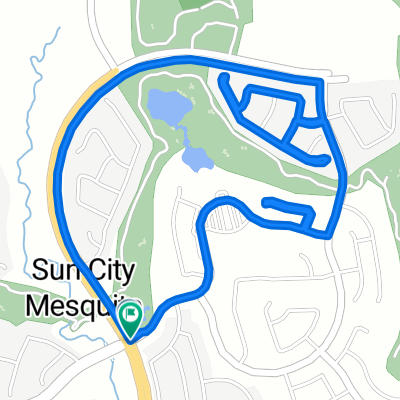
This rides starts at the corner of Flat Top Mesa Drive and Falcon Ridge Parkway; continues generally South through the two roundabouts, then jogs right off the second roundabout onto West Mesquite Boulevard; the ride continues East on West Mesquite Boulevard to a left (North) turn onto South Sandhill Boulevard; riders continue on South Sandhill Boulevard a short distance to a right (North) turn onto East Old Mill Road; almost immediately, riders take a left turn into the shopping center parking lot and continue riding around the back of the Smith's grocery store to Hillside Drive; turning right onto Hillside Drive (old Highway 91), riders now ride up a steep hill into Arizona and continue to follow Highway 91 to Scenic Drive; turning right onto Scenic drive, riders cross the Virgin River and begin a steep (but short climb, then a gentle to climb all the way to Elbow Canyon Road; turning right riders follow Elbow Canyon Road until the asphalt pavement ends; there the riders turn around and head back into Mesquite following the same route, this time enjoying very nice down hills and flats to just short of the Arizona border; then a short steep climb into Nevada and continuing to the Smith's parking lot, where the riders again ride behind the store to East Old Mill Road; the ride continues by turning right onto East Old Mill Road and riding to the intersection of West Mesquite Boulevard, where the riders turn right; West Mesquite Boulevard is ridden West, then jogging right through both roundabouts onto Falcon Ridge Parkway; the ride ends by following Falcon Ridge Parkway up hill back to the intersection of Flat Top Mesa Drive and Falcon Ridge Parkway. Total Ride Distance: 29.8 Miles.
Notes: 1. If you open the route in Google Roadmap or Google Hybrid (pulled down from the "Relief Map" tab) you will get a more up-to-date view of the roads and paths. Some of the other maps are dated. 2. This mapping program tends to under-compute the total ride mileage by roughly 10%, based on mileage for this ride when it has been actually ridden.- -:--
- Duración
- 47,9 km
- Distancia
- 269 m
- Ascenso
- 273 m
- Descenso
- ---
- Velocidad Media
- ---
- Altitud máxima
Calidad de la ruta
Tipos de vía y superficies a lo largo de la ruta
Tipos de vía
Carretera
30,6 km
(64 %)
Carretera concurrida
10,9 km
(23 %)
Superficies
Pavimentado
16,4 km
(34 %)
Asfalto
16,4 km
(34 %)
Sin definir
31,5 km
(66 %)
Continuar con Bikemap
Usa, edita o descarga esta ruta en bici
¿Te gustaría recorrer Sun City Bike Club Hard Ride 2 Out and Back Through Scenic Arizona o personalizarla para tu propio viaje? Esto es lo que puedes hacer con esta ruta de Bikemap:
Funciones gratuitas
- Guarda esta ruta como favorita o en una colección
- Copia y planifica tu propia versión de esta ruta
- Sincroniza tu ruta con Garmin o Wahoo
Funciones Premium
Prueba gratuita de 3 días o pago único. Más información sobre Bikemap Premium.
- Navega esta ruta en iOS y Android
- Exporta un archivo GPX / KML de esta ruta
- Crea tu impresión personalizada (pruébala gratis)
- Descarga esta ruta para la navegación sin conexión
Descubre más funciones Premium.
Consigue Bikemap PremiumDe nuestra comunidad
Mesquite: Otras rutas populares que empiezan aquí
 Sun City Bike Club Easy Ride 3 (Tannery Cove)
- Distancia
- 4,5 km
- Ascenso
- 114 m
- Descenso
- 114 m
- Ubicación
- Mesquite, Nevada, Estados Unidos
 Mesquite, NV - Mount Charleston, NV
- Distancia
- 182,8 km
- Ascenso
- 2261 m
- Descenso
- 464 m
- Ubicación
- Mesquite, Nevada, Estados Unidos
 Mesquite half loop.
- Distancia
- 17,6 km
- Ascenso
- 253 m
- Descenso
- 256 m
- Ubicación
- Mesquite, Nevada, Estados Unidos
 Crescent Moon Crossing 830, Mesquite to Crescent Moon Bend 829, Mesquite
- Distancia
- 3,4 km
- Ascenso
- 44 m
- Descenso
- 45 m
- Ubicación
- Mesquite, Nevada, Estados Unidos
 Sun City Bike Club Easy Ride 2 Out and Back Around Mesquite (With Some Climbs)
- Distancia
- 20,1 km
- Ascenso
- 81 m
- Descenso
- 82 m
- Ubicación
- Mesquite, Nevada, Estados Unidos
 Mesquite, NV - Dolan Springs, NV
- Distancia
- 238,4 km
- Ascenso
- 1600 m
- Descenso
- 1046 m
- Ubicación
- Mesquite, Nevada, Estados Unidos
 Cycle-a-thon for Cancer
- Distancia
- 16,3 km
- Ascenso
- 132 m
- Descenso
- 162 m
- Ubicación
- Mesquite, Nevada, Estados Unidos
 Sun City Bike Club Easy Ride 4 (Wagon Wheel, Overland Trail and Frontier Pass Neighborhoods)
- Distancia
- 5 km
- Ascenso
- 91 m
- Descenso
- 89 m
- Ubicación
- Mesquite, Nevada, Estados Unidos
Ábrela en la app