

Kingussie, Glen Tromie and Gaick
Una ruta en bici que comienza en Kingussie, Escocia, Reino Unido.
Visión General
Sobre esta ruta
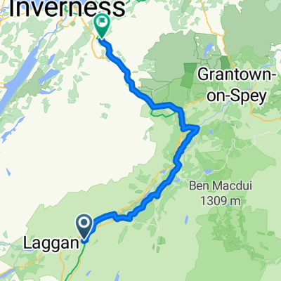
Esta es una ruta seria de 53 km / 33 millas que lleva a un remoto valle. Adecuado para bicicletas de montaña. Algunas secciones son de asfalto, pero largas secciones están en caminos ásperos de Land Rover y en un punto se requiere cruzar un río. Permita 5 horas. Hojas del Servicio de Ordenación 35 - Kingussie y las Montañas Monadliath, 42 - Glen Garry y Loch Rannoch. Refrigerios: Cafés y bares en Kingussie. Comience en el centro de la ciudad de Kingussie y tome la tranquila carretera menor B970 que pasa por los Ruthven Barracks. Después de una milla y media, toma el camino de césped que se bifurca a la derecha a través de una puerta. Siga este camino a través de la tierra y los árboles a lo largo del lado oeste del río Tromie hasta que llegue a la casa del guardabosques de Glen Tromie Lodge. Cruce el río por el puente aquí y gire a la derecha en el camino de Land Rover que conduce por el lado este del Tromie. Luego, el camino pasa por un tramo de árboles, pasa por Lynaberack Lodge, donde la superficie se vuelve asfaltada y luego cruza el río por un puente. Siempre siga el camino principal, ignorando cualquier camino lateral a la izquierda o derecha. Cuando la ruta alcanza Tromie Dam, la carretera asfaltada termina y el camino se convierte en un camino bien mantenido de Land Rover. Pase Loch an t-Seilach y la Gaick Lodge, donde el camino se vuelve más áspero. Justo después de la cabaña, en una bifurcación en el camino, gire a la derecha para cruzar el río nuevamente en una vado. Se debe tener cuidado aquí y si el nivel del río es demasiado alto, la ruta termina aquí. Si el agua es pasable, es mejor atravesar a pie que intentar andar en bicicleta. Después de pasar Loch Bhrodainn a la derecha, el camino se vuelve más empinado y alcanza Loch an Duin, aunque esta ruta termina donde termina el camino de Land Rover, antes de llegar al lago. Después de un merecido descanso, dé la vuelta y disfrute del regreso mucho más fácil por Glen Tromie por la ruta de ida. También es posible extender la ruta si no ha habido demasiada lluvia reciente a través de un camino en el lado este de Loch Duin. Esto se une a otro camino de Land Rover que lleva eventualmente a la Dalnacardoch Lodge. Desde aquí es posible unirse a la Ruta 7 de Sustrans que va hacia el norte volviendo a Newtonmore y Kingussie.
- -:--
- Duración
- 26,5 km
- Distancia
- 313 m
- Ascenso
- 57 m
- Descenso
- ---
- Velocidad Media
- ---
- Altitud máxima

Calidad de la ruta
Tipos de vía y superficies a lo largo de la ruta
Tipos de vía
Camino forestal
10,3 km
(39 %)
Carretera tranquila
10,1 km
(38 %)
Superficies
Pavimentado
10,9 km
(41 %)
Sin pavimentar
12,7 km
(48 %)
Asfalto
10,6 km
(40 %)
Sin asfaltar (sin definir)
6,4 km
(24 %)
Destacados de la ruta
Puntos de interés a lo largo de la ruta

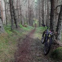
Foto después de 4,6 km
Bridge at Tromie Lodge

Foto después de 14,3 km
Bridge over Tromie

Foto después de 20,4 km
Gaick Lodge
Continuar con Bikemap
Usa, edita o descarga esta ruta en bici
¿Te gustaría recorrer Kingussie, Glen Tromie and Gaick o personalizarla para tu propio viaje? Esto es lo que puedes hacer con esta ruta de Bikemap:
Funciones gratuitas
- Guarda esta ruta como favorita o en una colección
- Copia y planifica tu propia versión de esta ruta
- Sincroniza tu ruta con Garmin o Wahoo
Funciones Premium
Prueba gratuita de 3 días o pago único. Más información sobre Bikemap Premium.
- Navega esta ruta en iOS y Android
- Exporta un archivo GPX / KML de esta ruta
- Crea tu impresión personalizada (pruébala gratis)
- Descarga esta ruta para la navegación sin conexión
Descubre más funciones Premium.
Consigue Bikemap PremiumDe nuestra comunidad
Kingussie: Otras rutas populares que empiezan aquí
 Kingussie/Inverness via Corrieyairack
- Distancia
- 104,2 km
- Ascenso
- 960 m
- Descenso
- 1177 m
- Ubicación
- Kingussie, Escocia, Reino Unido
 Newtonmore to Auchnahillin CS nr Moy
- Distancia
- 76,5 km
- Ascenso
- 344 m
- Descenso
- 348 m
- Ubicación
- Kingussie, Escocia, Reino Unido
 Kingussie, Newtonmore Wild Cat trail and Loch Gynack
- Distancia
- 16 km
- Ascenso
- 219 m
- Descenso
- 219 m
- Ubicación
- Kingussie, Escocia, Reino Unido
 Kingussie, Glen Tromie and Gaick
- Distancia
- 26,5 km
- Ascenso
- 313 m
- Descenso
- 57 m
- Ubicación
- Kingussie, Escocia, Reino Unido
 Kingussie to FeshieBridge 2
- Distancia
- 27,6 km
- Ascenso
- 235 m
- Descenso
- 235 m
- Ubicación
- Kingussie, Escocia, Reino Unido
 Inshriachs Best 3 Descents
- Distancia
- 19,6 km
- Ascenso
- 419 m
- Descenso
- 421 m
- Ubicación
- Kingussie, Escocia, Reino Unido
 From Crubenberg to Carrbridge
- Distancia
- 57,2 km
- Ascenso
- 394 m
- Descenso
- 436 m
- Ubicación
- Kingussie, Escocia, Reino Unido
 Day 5-East Daviot
- Distancia
- 77,7 km
- Ascenso
- 390 m
- Descenso
- 419 m
- Ubicación
- Kingussie, Escocia, Reino Unido
Ábrela en la app