Colle Vert Enduro (Verres Aosta)
- 21,8 km
- 1024 m
- 1025 m
- Verres, Región del Valle de Aosta, Italia
Sección después de Champurney incierta
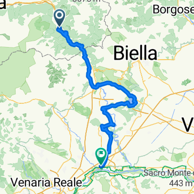
Itinerario: (Verrès –) Omens – Champore – Colle Vert – Fornelle – Barmelongue – Avieil – Champurney – Prouve Ville – Arnad – Verrès
Descripción del recorrido:
El recorrido comienza en Omens, a donde se puede llegar en coche. Luego se dirige hacia arriba en la empinada subida, inicialmente unos metros en asfalto, luego muchas curvas cerradas en tierra, 630 metros verticales cuesta arriba. Se llega al Colle Vert cuando se gira a la derecha en el camino de grava hacia Fornelle. Por cierto, siempre es posible disfrutar de una bonita vista del Matterhorn en la ascensión. El descenso comienza sin peligro en el camino de grava hacia Fornelle. Justo después de la última curva a la derecha antes de las primeras casas a la izquierda comienza el 2-Trail. El sendero estrecho serpentea a través del bosque empinado, alternando curvas cerradas con tramos rápidos y pasos para scooters, todo muy fluido pero con la concentración necesaria. Se cruza una pequeña carretera, luego el sendero es un poco más accidentado hasta llegar al caserío Avieil. Aquí se gira a la izquierda y se rueda por la pequeña carretera hacia Champurney. El descenso directo desde aquí a Arnad es un poco aburrido. Más emocionante es el 3-Trail, que se bifurca pronto a la derecha y serpentea de forma complicada y fluida hacia las casas de Prouve Ville. Va paralelo a la carretera principal y luego regresa a Verrès.
Prueba gratuita de 3 días o pago único. Más información sobre Bikemap Premium.
Descubre más funciones Premium.
Consigue Bikemap PremiumÁbrela en la app