

Heart of Switzerland
Una ruta en bici que comienza en Altdorf, Uri, Suiza.
Visión General
Sobre esta ruta
Featuring almost 50 kilometres of climbing, this loop calls for fitness and a love of adventure.
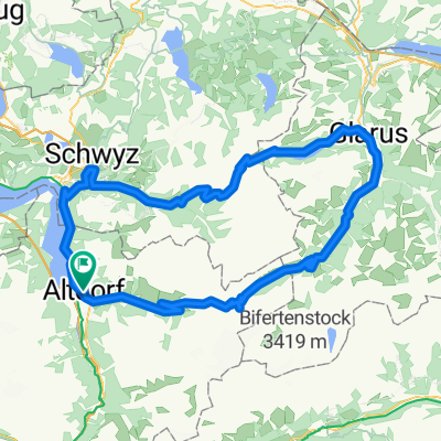
The road starts climbing the moment you leave Altdorf – moderately as far as Bürglen, birthplace of William Tell. That is where the ascent proper to the Klausen pass starts, one of the classic passes of the Tour de Suisse.
You soon find yourself entering the Schächen valley, which boasts a spectacular waterfall on the far flank.
The road just before Unterschächen features a slight descent for 1.5km – welcome respite before the final 12 kilometres of climbing, where the gradient is never less than 7%. The summit at alt. 1948m is finally reached after 24km of climbing.
The descent amid the cliffs is spectacular. The route flattens out for a few kilometres through the Urnerboden, a high-level valley dotted with farms where time seems to have stopped still.
A few more hairpins and you arrive in Linthal then Glarus. The next challenge is the Pragel pass up a narrow, tranquil road. The first part of the climb is steep, reaching Lake Klöntal ringed by awe-inspiring cliffs after 5km. This level section helps you gather your strength in readiness for the last 10 kilometres of pass road, culminating at alt. 1548m. It is closed to traffic at weekends.
The downhill to Schwyz is steep – thankfully the loop is not in the other direction! The return leg to Altdorf follows the craggy shoreline of Lake Lucerne.
- -:--
- Duración
- 133,7 km
- Distancia
- 2611 m
- Ascenso
- 2611 m
- Descenso
- ---
- Velocidad Media
- ---
- Altitud máxima

Calidad de la ruta
Tipos de vía y superficies a lo largo de la ruta
Tipos de vía
Carretera concurrida
50,7 km
(38 %)
Carretera
36,1 km
(27 %)
Superficies
Pavimentado
105,3 km
(79 %)
Sin pavimentar
11,5 km
(9 %)
Asfalto
101,9 km
(76 %)
Grava
6 km
(5 %)
Continuar con Bikemap
Usa, edita o descarga esta ruta en bici
¿Te gustaría recorrer Heart of Switzerland o personalizarla para tu propio viaje? Esto es lo que puedes hacer con esta ruta de Bikemap:
Funciones gratuitas
- Guarda esta ruta como favorita o en una colección
- Copia y planifica tu propia versión de esta ruta
- Divídelo en etapas para crear una excursión de varios días
- Sincroniza tu ruta con Garmin o Wahoo
Funciones Premium
Prueba gratuita de 3 días o pago único. Más información sobre Bikemap Premium.
- Navega esta ruta en iOS y Android
- Exporta un archivo GPX / KML de esta ruta
- Crea tu impresión personalizada (pruébala gratis)
- Descarga esta ruta para la navegación sin conexión
Descubre más funciones Premium.
Consigue Bikemap PremiumDe nuestra comunidad
Altdorf: Otras rutas populares que empiezan aquí
 Altdorf-Klausenpass (1948m)
- Distancia
- 25,1 km
- Ascenso
- 1579 m
- Descenso
- 122 m
- Ubicación
- Altdorf, Uri, Suiza
 Klausenpass + Pragelpass (Altdorf)
- Distancia
- 129,8 km
- Ascenso
- 2653 m
- Descenso
- 2656 m
- Ubicación
- Altdorf, Uri, Suiza
 Route«1291» Etappe 2: Altdorf – Andermatt
- Distancia
- 37 km
- Ascenso
- 1082 m
- Descenso
- 109 m
- Ubicación
- Altdorf, Uri, Suiza
 008 Altdorf - Willerzell, SA 01.08.20
- Distancia
- 47,7 km
- Ascenso
- 905 m
- Descenso
- 473 m
- Ubicación
- Altdorf, Uri, Suiza
 Isenthal Bike - 403 SchweizMobil
- Distancia
- 34,2 km
- Ascenso
- 1582 m
- Descenso
- 1396 m
- Ubicación
- Altdorf, Uri, Suiza
 klausen pass Pragel pass
- Distancia
- 130,4 km
- Ascenso
- 2809 m
- Descenso
- 2809 m
- Ubicación
- Altdorf, Uri, Suiza
 519. "Klausenpass und Ober Nas" (Teil 2 von 3)
- Distancia
- 65,2 km
- Ascenso
- 1555 m
- Descenso
- 1532 m
- Ubicación
- Altdorf, Uri, Suiza
 Klausenpass_Pragelpass
- Distancia
- 130,9 km
- Ascenso
- 2641 m
- Descenso
- 2641 m
- Ubicación
- Altdorf, Uri, Suiza
Ábrela en la app