- 81,6 km
- 674 m
- 680 m
- Murwillumbah, Nueva Gales del Sur, Australia
GCBW - Around Mount Warning
Una ruta en bici que comienza en Murwillumbah, Nueva Gales del Sur, Australia.
Visión General
Sobre esta ruta
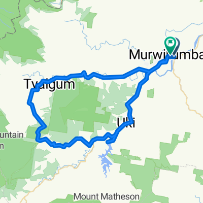
We start off at UKi and travel East and then North along the Kyogle Road following the Tweed River. At around 10k we trun left onto the Tyalgum Road which follows the Oxley River. We stop at Tyalgum for morning tea. We then head South on Brays Creek Road. At 33k veer left onto Byrrill Creek road. We steadily climb though bushland on an unsealed road. At the 38k mark we start to descend with glimpses of the Byrrill creek on the right and Mount Warning on our left. At 49.8k we turn left into the Kyogle Road which we follow to Uki. Lunch at Uki in the park or at the coffee shop or pub.
- -:--
- Duración
- 56,7 km
- Distancia
- 399 m
- Ascenso
- 400 m
- Descenso
- ---
- Velocidad Media
- ---
- Altitud máxima
creado hace 8 años
Continuar con Bikemap
Usa, edita o descarga esta ruta en bici
¿Te gustaría recorrer GCBW - Around Mount Warning o personalizarla para tu propio viaje? Esto es lo que puedes hacer con esta ruta de Bikemap:
Funciones gratuitas
- Guarda esta ruta como favorita o en una colección
- Copia y planifica tu propia versión de esta ruta
- Sincroniza tu ruta con Garmin o Wahoo
Funciones Premium
Prueba gratuita de 3 días o pago único. Más información sobre Bikemap Premium.
- Navega esta ruta en iOS y Android
- Exporta un archivo GPX / KML de esta ruta
- Crea tu impresión personalizada (pruébala gratis)
- Descarga esta ruta para la navegación sin conexión
Descubre más funciones Premium.
Consigue Bikemap PremiumDe nuestra comunidad
Murwillumbah: Otras rutas populares que empiezan aquí
- S2 Murwillumban - Mebbin State Forest - Murwillumban
- Recorded on 13 Oct 2023 at 16:31
- 25,4 km
- 236 m
- 228 m
- Murwillumbah, Nueva Gales del Sur, Australia
- MUST DO: Murwillumbah Loop. *early
- 79,5 km
- 1463 m
- 1464 m
- Murwillumbah, Nueva Gales del Sur, Australia
- Northern Rivers Rail Trail, South Murwillumbah to Northern Rivers Rail Trail, South Murwillumbah
- 13,2 km
- 117 m
- 118 m
- Murwillumbah, Nueva Gales del Sur, Australia
- northern river rail trail part 1
- 10,1 km
- 60 m
- 95 m
- Murwillumbah, Nueva Gales del Sur, Australia
- Northern Rivers Rail Trail (N>S)
- 24,2 km
- 206 m
- 179 m
- Murwillumbah, Nueva Gales del Sur, Australia
- 18 around the Mount Warning
- 69,2 km
- 402 m
- 405 m
- Murwillumbah, Nueva Gales del Sur, Australia
- Stokers Road 288, Stokers Siding to Tweed Valley Way 284, South Murwillumbah
- 7,5 km
- 7 m
- 58 m
- Murwillumbah, Nueva Gales del Sur, Australia
Ábrela en la app


