

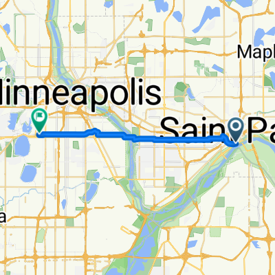
B2B00192 55102>55404viaShepherdRd/MissBlvd/WRiverPkwy/MidtwnGrnway
Una ruta en bici que comienza en Saint Paul, Minnesota, Estados Unidos.
Visión General
Sobre esta ruta
Esta ruta es decididamente más larga, pero es mucho más interesante y rápida. Hay muy pocas paradas en comparación con una ruta cruzada por la ciudad. Toma Shepherd Road West a lo largo del río Mississippi. Puedes andar en el sendero para bicicletas o en la carretera. Sigue Shepherd Rd. hasta 35E hasta que se convierta en East Mississippi River Blvd. Continúa por East Mississippi más allá de la planta de Ford. Pasa por debajo del puente de Ford Pkwy. y haz un giro en U inmediato a Ford Pkwy. y cruza el Mississippi en el puente de Ford. Inmediatamente al final del puente hay un camino a la derecha que te llevará hasta West River Pkwy. Sigue West River Pkwy. en la carretera o en el sendero para bicicletas. Pasa por debajo de Lake Street y continúa. En E.27th Street hay un sendero que sube hacia el Midtown Greenway Bike Trail. Toma el sendero para bicicletas hacia el oeste. En Hiawatha Avenue puedes continuar recto y cruzar con el tráfico de semáforos o seguir por el sendero para bicicletas sobre el nuevo puente Martin Sabo. (Muy genial por la noche con luces azules). Continúa por la Greenway hasta llegar a Chicago Avenue. Sal por las escaleras hacia la calle y dirígete hacia el norte en Chicago hasta 26th Street y tu destino.
- -:--
- Duración
- 21,8 km
- Distancia
- 131 m
- Ascenso
- 86 m
- Descenso
- ---
- Velocidad Media
- 258 m
- Altitud máxima
Calidad de la ruta
Tipos de vía y superficies a lo largo de la ruta
Tipos de vía
Carril bici
16,8 km
(77 %)
Carretera
3,9 km
(18 %)
Superficies
Pavimentado
12,9 km
(59 %)
Asfalto
11,6 km
(53 %)
Hormigón
0,9 km
(4 %)
Destacados de la ruta
Puntos de interés a lo largo de la ruta
Punto de interés después de 18,9 km
At this point you can continue across Hiawatha to E. 28th Street with the traffic signals or continue on the bike path to the north and over the Martin Sabo bridge.
Continuar con Bikemap
Usa, edita o descarga esta ruta en bici
¿Te gustaría recorrer B2B00192 55102>55404viaShepherdRd/MissBlvd/WRiverPkwy/MidtwnGrnway o personalizarla para tu propio viaje? Esto es lo que puedes hacer con esta ruta de Bikemap:
Funciones gratuitas
- Guarda esta ruta como favorita o en una colección
- Copia y planifica tu propia versión de esta ruta
- Sincroniza tu ruta con Garmin o Wahoo
Funciones Premium
Prueba gratuita de 3 días o pago único. Más información sobre Bikemap Premium.
- Navega esta ruta en iOS y Android
- Exporta un archivo GPX / KML de esta ruta
- Crea tu impresión personalizada (pruébala gratis)
- Descarga esta ruta para la navegación sin conexión
Descubre más funciones Premium.
Consigue Bikemap PremiumDe nuestra comunidad
Saint Paul: Otras rutas populares que empiezan aquí
 To the River Center
- Distancia
- 17,1 km
- Ascenso
- 117 m
- Descenso
- 90 m
- Ubicación
- Saint Paul, Minnesota, Estados Unidos
 St Paul Gateway to: Brown’s creek to Stillwater and back .
- Distancia
- 64,2 km
- Ascenso
- 408 m
- Descenso
- 409 m
- Ubicación
- Saint Paul, Minnesota, Estados Unidos
 B2B00024 55104 > 55121 via Big Rivers Trail
- Distancia
- 16,8 km
- Ascenso
- 174 m
- Descenso
- 174 m
- Ubicación
- Saint Paul, Minnesota, Estados Unidos
 Gateway State Trail
- Distancia
- 30 km
- Ascenso
- 115 m
- Descenso
- 69 m
- Ubicación
- Saint Paul, Minnesota, Estados Unidos
 B2B00192 55102>55404viaShepherdRd/MissBlvd/WRiverPkwy/MidtwnGrnway
- Distancia
- 21,8 km
- Ascenso
- 131 m
- Descenso
- 86 m
- Ubicación
- Saint Paul, Minnesota, Estados Unidos
 B2B00062 55106 - 55075 via Concord, NURT
- Distancia
- 9,5 km
- Ascenso
- 80 m
- Descenso
- 110 m
- Ubicación
- Saint Paul, Minnesota, Estados Unidos
 B2B00368 55102 > 55417 via Shepard Rd, Godfrey, Minnehaha, River Pkwy
- Distancia
- 17,8 km
- Ascenso
- 96 m
- Descenso
- 119 m
- Ubicación
- Saint Paul, Minnesota, Estados Unidos
 Jackson Street to East 7th Street
- Distancia
- 1,6 km
- Ascenso
- 36 m
- Descenso
- 0 m
- Ubicación
- Saint Paul, Minnesota, Estados Unidos
Ábrela en la app