

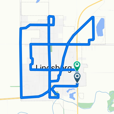
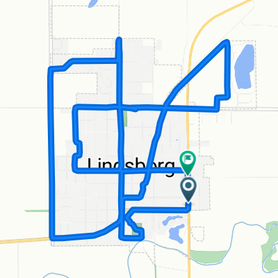
Lindsborg to Coronado Heights
Una ruta en bici que comienza en Lindsborg, Kansas, Estados Unidos.
Visión General
Sobre esta ruta
Este corto paseo de Lindsborg a Coronado Heights es una hermosa forma de comenzar o terminar tu día.
Uno de los hitos más reconocibles en el Valle del Río Smoky Hill en el centro de Kansas es el Parque Coronado Heights, que figura en los Registros Nacionales y de Kansas de Lugares Históricos y fue votado como una de las 8 Maravillas de la Geografía de Kansas por los miembros de la Kansas Sampler Foundation.
Los primeros pioneros suecos se asentaron originalmente en la base del acantilado, pero eventualmente trasladaron la comunidad al piso del valle. Anna Olsson, hija de uno de los fundadores de Lindsborg, el Rev. Olaf Olsson, escribió en su memoria Hija de la Pradera que al mirar desde la cima de las Heights, cuando estaba nostálgica, imaginaba ver hasta Suecia.
Dominando a 300 pies sobre el Valle del Río Smoky Hill, Coronado Heights, ubicado a unas 3 millas al noroeste de Lindsborg, se encuentra en el borde sur de una sucesión de siete colinas conocidas como los Buttes Españoles (o a veces los Buttes de Smoky Hill). La Formación Dakota se depositó hace unos 100 millones de años. El Coronado Heights sigue siendo un hábitat natural de flores silvestres y pastos. Yucca, grosellas, lagartijas Prairie Racerunner, zumaque, salvia y spiderwort prosperan. Debido a su belleza natural, es un lugar popular para bodas y reuniones familiares.
El desarrollo del Parque Coronado Heights comenzó en 1919 con la formación de la Sociedad Histórica de Lindsborg, antecesora de la Asociación Histórica de Smoky Valley. Se construyó una casa de refugio alrededor del área de picnic y cocina en medio de la cima de la colina. La carretera original, para permitir el acceso de automóviles a la cima, se construyó en 1920 y se llamó Swensson Drive en memoria de Carl Aaron Swensson, fundador del Bethany College. Un sendero, ahora la escalera ubicada a medio camino de la colina, se llama Olsson Trail, en honor a Olaf Olsson, líder de uno de los primeros grupos de suecos que se asentaron en el valle. A principios de la historia del Smoky Valley, era evidente que el Parque Coronado Heights sería valorado y accesible para que todos lo disfrutaran. Como dice la escultura de 1988 de John Whitfield, situada a medio camino de la carretera, "Un lugar para compartir."
El Parque Coronado Heights es donde los residentes del Smoky Valley van a observar el clima cambiante de Kansas. Los artistas y fotógrafos han convergido durante años en Coronado Heights por el excepcional panorama. La suave arenisca nativa de Dakota está cubierta de nombres y fechas de hace años. Senderos para caminar y andar en bicicleta serpentean alrededor del acantilado. Aunque algunos tienen la idea errónea de que el mismo Coronado construyó el castillo de estilo español, en realidad fue construido en 1936 por trabajadores de la Works Progress Administration. Es el lugar para ver un amanecer o un atardecer. Es el lugar perfecto para volar una cometa o un avión de control remoto, hacer un picnic, reunirse con amigos y llevar a visitantes para mostrarles el paisaje del Smoky Valley.
- -:--
- Duración
- 14,7 km
- Distancia
- 106 m
- Ascenso
- 106 m
- Descenso
- ---
- Velocidad Media
- ---
- Altitud máxima

Fotos de la ruta


Calidad de la ruta
Tipos de vía y superficies a lo largo de la ruta
Tipos de vía
Carretera tranquila
7,6 km
(52 %)
Carretera
7 km
(48 %)
Superficies
Sin pavimentar
1,6 km
(11 %)
Grava
1,6 km
(11 %)
Sin definir
13,1 km
(89 %)
Continuar con Bikemap
Usa, edita o descarga esta ruta en bici
¿Te gustaría recorrer Lindsborg to Coronado Heights o personalizarla para tu propio viaje? Esto es lo que puedes hacer con esta ruta de Bikemap:
Funciones gratuitas
- Guarda esta ruta como favorita o en una colección
- Copia y planifica tu propia versión de esta ruta
- Sincroniza tu ruta con Garmin o Wahoo
Funciones Premium
Prueba gratuita de 3 días o pago único. Más información sobre Bikemap Premium.
- Navega esta ruta en iOS y Android
- Exporta un archivo GPX / KML de esta ruta
- Crea tu impresión personalizada (pruébala gratis)
- Descarga esta ruta para la navegación sin conexión
Descubre más funciones Premium.
Consigue Bikemap PremiumDe nuestra comunidad
Lindsborg: Otras rutas populares que empiezan aquí
 Välkommen Trail - Lindsborg
- Distancia
- 5 km
- Ascenso
- 11 m
- Descenso
- 9 m
- Ubicación
- Lindsborg, Kansas, Estados Unidos
 Lindsborg to Coronado Heights
- Distancia
- 14,7 km
- Ascenso
- 106 m
- Descenso
- 106 m
- Ubicación
- Lindsborg, Kansas, Estados Unidos
 South Cole Street to South Cole Street
- Distancia
- 16 km
- Ascenso
- 81 m
- Descenso
- 56 m
- Ubicación
- Lindsborg, Kansas, Estados Unidos
 Lindsborg/Roxbury/Gypsum Loop
- Distancia
- 76,2 km
- Ascenso
- 198 m
- Descenso
- 200 m
- Ubicación
- Lindsborg, Kansas, Estados Unidos
 Cole1
Cole1- Distancia
- 16,1 km
- Ascenso
- 83 m
- Descenso
- 62 m
- Ubicación
- Lindsborg, Kansas, Estados Unidos
 Lindsborg to Maxwell Wildlife Refuge
- Distancia
- 70,8 km
- Ascenso
- 298 m
- Descenso
- 300 m
- Ubicación
- Lindsborg, Kansas, Estados Unidos
 708 Emerald Dr, Lindsborg to Bethany Dr, Lindsborg
- Distancia
- 22,6 km
- Ascenso
- 154 m
- Descenso
- 152 m
- Ubicación
- Lindsborg, Kansas, Estados Unidos
 Lindsborg via the Meadowlark Trail to Marquette
- Distancia
- 49 km
- Ascenso
- 86 m
- Descenso
- 89 m
- Ubicación
- Lindsborg, Kansas, Estados Unidos
Ábrela en la app