

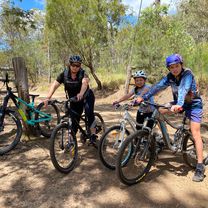
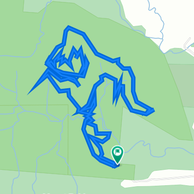
Day 2: Lake Tinaroo Circuit
Una ruta en bici que comienza en Atherton, State of Queensland, Australia.
Visión General
Sobre esta ruta
The Tinaroo loop is a mixture of sealed and dirt rd and circumnavigates the tropical paradise of lake Tinaroo. If you would like to do some extra kms and experience some elevated views you can spend an hours or so ascending up Lamb’s range. There is a turn off to the Lambs Range at the start of the lake circuit. Cathedral Figtree is also worth a look. It is located at the start of the circuit as well and it is well signposted. Stop at the Tinaroo village for food and the strawberry farm for ice cream. The road back to Yungaburra on the last part of the circuit has only a small cycling shoulder. You will need to ride this road for about 10km to get back to Yungaburra.
- -:--
- Duración
- 71,8 km
- Distancia
- 650 m
- Ascenso
- 649 m
- Descenso
- ---
- Velocidad Media
- ---
- Altitud máxima
Continuar con Bikemap
Usa, edita o descarga esta ruta en bici
¿Te gustaría recorrer Day 2: Lake Tinaroo Circuit o personalizarla para tu propio viaje? Esto es lo que puedes hacer con esta ruta de Bikemap:
Funciones gratuitas
- Guarda esta ruta como favorita o en una colección
- Copia y planifica tu propia versión de esta ruta
- Sincroniza tu ruta con Garmin o Wahoo
Funciones Premium
Prueba gratuita de 3 días o pago único. Más información sobre Bikemap Premium.
- Navega esta ruta en iOS y Android
- Exporta un archivo GPX / KML de esta ruta
- Crea tu impresión personalizada (pruébala gratis)
- Descarga esta ruta para la navegación sin conexión
Descubre más funciones Premium.
Consigue Bikemap PremiumDe nuestra comunidad
Atherton: Otras rutas populares que empiezan aquí
 Atherton Herberton
- Distancia
- 20,1 km
- Ascenso
- 340 m
- Descenso
- 245 m
- Ubicación
- Atherton, State of Queensland, Australia
 22-01-25 Ath mtb, 1,6,1,ft, rd
- Distancia
- 8,7 km
- Ascenso
- 224 m
- Descenso
- 205 m
- Ubicación
- Atherton, State of Queensland, Australia
 Atherton Tablelands Rail Trail, Atherton to 24 Albrecht Street, Atherton
- Distancia
- 7,6 km
- Ascenso
- 112 m
- Descenso
- 114 m
- Ubicación
- Atherton, State of Queensland, Australia
 22-02-22 Malanda loop
- Distancia
- 19,7 km
- Ascenso
- 231 m
- Descenso
- 233 m
- Ubicación
- Atherton, State of Queensland, Australia
 Day 4: Yungaburra to Millaa Millaa (The Falls Tea House)
- Distancia
- 73,8 km
- Ascenso
- 782 m
- Descenso
- 638 m
- Ubicación
- Atherton, State of Queensland, Australia
 Rifle Range Road, Atherton to Rifle Range Road, Atherton
- Distancia
- 7,8 km
- Ascenso
- 221 m
- Descenso
- 223 m
- Ubicación
- Atherton, State of Queensland, Australia
 Atherton - Herberton
- Distancia
- 19,6 km
- Ascenso
- 342 m
- Descenso
- 200 m
- Ubicación
- Atherton, State of Queensland, Australia
 21-12-17 Ath mtb 1,6,7,6,1,rd
- Distancia
- 11 km
- Ascenso
- 191 m
- Descenso
- 172 m
- Ubicación
- Atherton, State of Queensland, Australia
Ábrela en la app