

Tour de Winooski
Una ruta en bici que comienza en Winooski, Vermont, Estados Unidos.
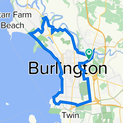
Visión General
Sobre esta ruta
La Tour de Winooski es un recorrido ciclista autoguiado propuesto que comienza en el Intervale Center. Este centro de agricultura comunitaria es un recurso para la producción de alimentos cultivados y operados localmente en el área de Burlington, y está cerca de signos de historia geológica en la próxima parada del recorrido, Salmon Hole. Esta área natural en el río Winooski es un hábitat importante para especies de peces ribereños y muestra su historia geológica a través de los afloramientos de dolomita que alberga. La siguiente ubicación en el recorrido en bicicleta es la fábrica de Ben & Jerry’s en Waterbury, VT. Esta es una fábrica de producción de alimentos locales que es amada por muchos vermonteses y personas de todo el mundo. Antes de que los ciclistas lleguen a Waterbury, pasarán en bicicleta por Mt. Mansfield, que es el pico montañoso más alto de Vermont. La siguiente parada en el recorrido es el Hubbard Tower en Montpelier. Los ciclistas pueden subir a la torre de observación y observar la geología de la cuenca del Winooski a través de las vistas de los Green Mountains que los rodean. Si están cansados, los ciclistas pueden pasar la noche en uno de los múltiples bed and breakfasts de propiedad local en Montpelier. Por la mañana, los ciclistas seguirán el recorrido hacia Barre. Pueden recoger algunos víveres y pensar en geología en Granite City Grocery, la cooperativa de comestibles en Barre. En este punto de la ruta en bicicleta, es hora de dar la vuelta. Los ciclistas seguirán por el recorrido en un largo trayecto de regreso a Burlington, donde podrán disfrutar de comida local de una variedad de restaurantes y descansar en el Burlington Hostel.
- -:--
- Duración
- 165,6 km
- Distancia
- 549 m
- Ascenso
- 525 m
- Descenso
- ---
- Velocidad Media
- ---
- Altitud máxima

Calidad de la ruta
Tipos de vía y superficies a lo largo de la ruta
Tipos de vía
Carretera
69,5 km
(42 %)
Carretera tranquila
28,2 km
(17 %)
Superficies
Pavimentado
124,2 km
(75 %)
Sin pavimentar
36,4 km
(22 %)
Asfalto
120,9 km
(73 %)
Grava
31,5 km
(19 %)
Continuar con Bikemap
Usa, edita o descarga esta ruta en bici
¿Te gustaría recorrer Tour de Winooski o personalizarla para tu propio viaje? Esto es lo que puedes hacer con esta ruta de Bikemap:
Funciones gratuitas
- Guarda esta ruta como favorita o en una colección
- Copia y planifica tu propia versión de esta ruta
- Divídelo en etapas para crear una excursión de varios días
- Sincroniza tu ruta con Garmin o Wahoo
Funciones Premium
Prueba gratuita de 3 días o pago único. Más información sobre Bikemap Premium.
- Navega esta ruta en iOS y Android
- Exporta un archivo GPX / KML de esta ruta
- Crea tu impresión personalizada (pruébala gratis)
- Descarga esta ruta para la navegación sin conexión
Descubre más funciones Premium.
Consigue Bikemap PremiumDe nuestra comunidad
Winooski: Otras rutas populares que empiezan aquí
 commute home
- Distancia
- 16,7 km
- Ascenso
- 210 m
- Descenso
- 160 m
- Ubicación
- Winooski, Vermont, Estados Unidos
 54 Russell St, Winooski to Island Line Trail, Burlington
- Distancia
- 7,3 km
- Ascenso
- 59 m
- Descenso
- 97 m
- Ubicación
- Winooski, Vermont, Estados Unidos
 BTV to Montreal
- Distancia
- 187,9 km
- Ascenso
- 253 m
- Descenso
- 264 m
- Ubicación
- Winooski, Vermont, Estados Unidos
 flat loop around colchester
- Distancia
- 21,3 km
- Ascenso
- 158 m
- Descenso
- 152 m
- Ubicación
- Winooski, Vermont, Estados Unidos
 Burlington city route
- Distancia
- 26,2 km
- Ascenso
- 229 m
- Descenso
- 229 m
- Ubicación
- Winooski, Vermont, Estados Unidos
 Ride to work :)
- Distancia
- 15,8 km
- Ascenso
- 125 m
- Descenso
- 178 m
- Ubicación
- Winooski, Vermont, Estados Unidos
 Tour de Winooski
- Distancia
- 165,6 km
- Ascenso
- 549 m
- Descenso
- 525 m
- Ubicación
- Winooski, Vermont, Estados Unidos
 Sporty route in Essex Junction
- Distancia
- 13,9 km
- Ascenso
- 147 m
- Descenso
- 103 m
- Ubicación
- Winooski, Vermont, Estados Unidos
Ábrela en la app