

Route to Headflyer Brewing
- 9,1 km
- 100 m
- 69 m
- Richfield, Minnesota, Estados Unidos
Una ruta en bici que comienza en Richfield, Minnesota, Estados Unidos.
Visión General
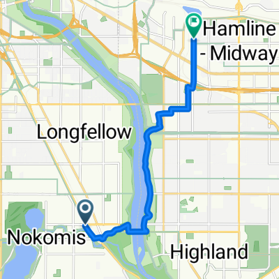
Take Logan north to 49th St.
Right onto 49th St and continue on to Minnehaha Pkwy.
Left onto Minnehaha Pkwy and continue to Lake Harriet.
Bike to the right and continue counter clockwise around the lake about 2 blocks until you reach 46th St.
Take a right onto 46th Street and take a left onto Bryant.
Take Bryant (a bike-friendly street) north to Franklin. Take a right onto Franklin and take a left on Lyndale.
On the east side of Lyndale JUST north of Franklin (where 94 entrance ramp is) you will see that a bike/pedestrian path begins. Take that to Loring Park.
Follow the bike path in Loring Park to the northeastern corner of the park (forward and to the right).
Continue heading east and get onto Harmon Place. (you should walk your bike through a brief brick sidewalk area to get to the street part).
Take a right onto 10th which has a bike lane. Take a left onto Marquette into the bike lane. Take Marquette to 6th, and turn right.
creado hace 17 años
Calidad de la ruta
Carril bici
4,3 km
(43 %)
Carretera tranquila
2,8 km
(28 %)
Pavimentado
8 km
(81 %)
Hormigón
4,6 km
(46 %)
Asfalto
3,4 km
(34 %)
Continuar con Bikemap
¿Te gustaría recorrer B2B00371 55419 > 55415 via Bryant o personalizarla para tu propio viaje? Esto es lo que puedes hacer con esta ruta de Bikemap:
Prueba gratuita de 3 días o pago único. Más información sobre Bikemap Premium.
Descubre más funciones Premium.
Consigue Bikemap PremiumDe nuestra comunidad
Ábrela en la app


