

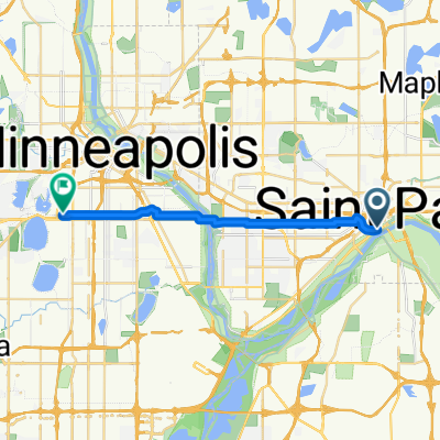
B2B00368 55102 > 55417 via Shepard Rd, Godfrey, Minnehaha, River Pkwy
Una ruta en bici que comienza en Saint Paul, Minnesota, Estados Unidos.
Visión General
Sobre esta ruta
Take Kellog past 7th St, and veer right onto Eagle Pkwy.
Follow Eagle Pkwy down the hill to Shepard Rd (at the bottom of the hill).
On the river side of Shepard Rd is a bike path.
Take the Shepard Rd bike path all the way to Ford Pkwy. (Note: when you have to cross under 35E, you must follow the trail as it dips out of the way south for a little bit, but it will curve back north, don't worry!)
At Ford Pkwy, take a left and cross the bridge. When you get over the bridge, traffic is iffy for about the equivelant of 1 block. You can walk your bike on the sidewalk for this patch if you dont feel comfortable in the street.
Take a left onto 46th Ave (the first turn you can take once you're over the bridge).
Take 46th Ave down the hill to the stopsign (note: there are bumpy cobblestones for a patch)
Take a rigth onto Godfrey Rd and follow that in the bike path until just before you reach the roundabout, and take a left to head south east on Minnehaha Avenue in the bike path.
Continue on Minnehaha Avenue until your reach 54th St E (note: along the way Minnehaha turns into River pkwy)
Take a right on 54th St. to cross Hiawatha.
Continue on 54th about 2 blocks and take a left onto Minnehaha Avenue.
Continue on Minnehaha to your desination.
- -:--
- Duración
- 17,8 km
- Distancia
- 96 m
- Ascenso
- 119 m
- Descenso
- ---
- Velocidad Media
- 264 m
- Altitud máxima
Calidad de la ruta
Tipos de vía y superficies a lo largo de la ruta
Tipos de vía
Carril bici
10,7 km
(60 %)
Carretera tranquila
2 km
(11 %)
Superficies
Pavimentado
14,4 km
(81 %)
Sin pavimentar
2 km
(11 %)
Asfalto
12,8 km
(72 %)
Grava
1,2 km
(7 %)
Continuar con Bikemap
Usa, edita o descarga esta ruta en bici
¿Te gustaría recorrer B2B00368 55102 > 55417 via Shepard Rd, Godfrey, Minnehaha, River Pkwy o personalizarla para tu propio viaje? Esto es lo que puedes hacer con esta ruta de Bikemap:
Funciones gratuitas
- Guarda esta ruta como favorita o en una colección
- Copia y planifica tu propia versión de esta ruta
- Sincroniza tu ruta con Garmin o Wahoo
Funciones Premium
Prueba gratuita de 3 días o pago único. Más información sobre Bikemap Premium.
- Navega esta ruta en iOS y Android
- Exporta un archivo GPX / KML de esta ruta
- Crea tu impresión personalizada (pruébala gratis)
- Descarga esta ruta para la navegación sin conexión
Descubre más funciones Premium.
Consigue Bikemap PremiumDe nuestra comunidad
Saint Paul: Otras rutas populares que empiezan aquí
 Way to Church
- Distancia
- 13,2 km
- Ascenso
- 54 m
- Descenso
- 37 m
- Ubicación
- Saint Paul, Minnesota, Estados Unidos
 River Ramble 20
- Distancia
- 29,6 km
- Ascenso
- 196 m
- Descenso
- 197 m
- Ubicación
- Saint Paul, Minnesota, Estados Unidos
 B2B00629 55102 < 55402 via Summit, River Road, West bank, Downtown
- Distancia
- 15,5 km
- Ascenso
- 82 m
- Descenso
- 94 m
- Ubicación
- Saint Paul, Minnesota, Estados Unidos
 B2B00368 55102 > 55417 via Shepard Rd, Godfrey, Minnehaha, River Pkwy
- Distancia
- 17,8 km
- Ascenso
- 96 m
- Descenso
- 119 m
- Ubicación
- Saint Paul, Minnesota, Estados Unidos
 B2B00192 55102>55404viaShepherdRd/MissBlvd/WRiverPkwy/MidtwnGrnway
- Distancia
- 21,8 km
- Ascenso
- 131 m
- Descenso
- 86 m
- Ubicación
- Saint Paul, Minnesota, Estados Unidos
 B2B00418 55117>55123 via Cedar, Wabasha, Lexington, Pilot Knob Rd
- Distancia
- 20,8 km
- Ascenso
- 161 m
- Descenso
- 156 m
- Ubicación
- Saint Paul, Minnesota, Estados Unidos
 Jackson Street to East 7th Street
- Distancia
- 1,6 km
- Ascenso
- 36 m
- Descenso
- 0 m
- Ubicación
- Saint Paul, Minnesota, Estados Unidos
 To the River Center
- Distancia
- 17,1 km
- Ascenso
- 117 m
- Descenso
- 90 m
- Ubicación
- Saint Paul, Minnesota, Estados Unidos
Ábrela en la app