B2B00331 55417 > 55404 via Minnehaha
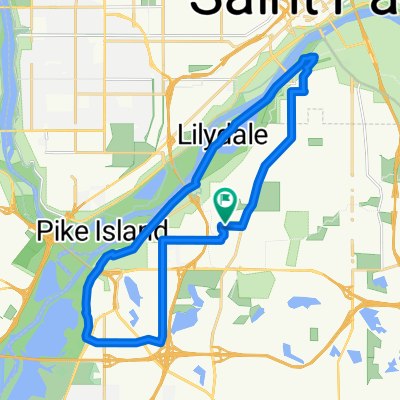
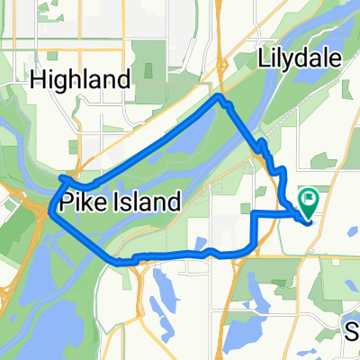
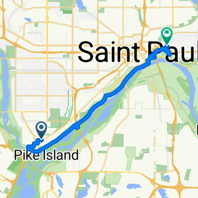
Una ruta en bici que comienza en Mendota Heights, Minnesota, United States of America.
Visión General
Sobre esta ruta
1. Take 54th St east to Minnehaha.
-
Take Minnehaha Ave bike path northwest all the way to Lake Street.
-
Cross Lake Street as Minnehaha Ave changes to 26th Ave S and continue north to 26th Street.
At this point you can either continue on 26th all the way through to Riverside and 26th. 26th is safe, but there is no bike lane. The route that is mapped is on more bike paths, as follows
-
Take a left onto 26th St. and look for the light rail trail bike path (which appears right before Hiawatha Ave).
-
Take a right onto the trail, and follow the path until it ends at 11th Avenue.
6. Take a left onto 11th, and follow the bike lane to 5th St.
7. Take a right onto 5th street. (note: 5th St is without a bike lane but traffic should be manageable. Also, veer to the left of the LRT once given the option to choose a side of the tracks).
8. Take 5th up to Portland and take a left into the bike lane.
9. Take Portland to 15th St, and take a right.
- Take 15th over the bridge and to the stoplight, where you can only turn left (because it ends in a pkg lot).
11. Turn left (onto 16th St) and follow the curve to the right. You will see your first right turn is 3rd Ave S.
12. Take a right onto 3rd Ave S which takes you to your destination. Note: Once you turn off of Portland, there are no more bike lanes on this route, but there aren't any other options unforunately. The traffic is usually manageble in this area, though, and there are wide shoulders.
Another option for step 12 is:
Continue on 16th Street to Nicollet, take a right. Take Nicollet Ave to 12th st, and turn into the bike lane there.
- -:--
- Duración
- 12,5 km
- Distancia
- 15 m
- Ascenso
- 12 m
- Descenso
- ---
- Velocidad Media
- 257 m
- Altitud máxima
Calidad de la ruta
Tipos de vía y superficies a lo largo de la ruta
Tipos de vía
Carretera
4 km
(32 %)
Carril bici
2,5 km
(20 %)
Superficies
Pavimentado
7,1 km
(57 %)
Asfalto
5,6 km
(45 %)
Hormigón
1,2 km
(10 %)
Continuar con Bikemap
Usa, edita o descarga esta ruta en bici
¿Te gustaría recorrer B2B00331 55417 > 55404 via Minnehaha o personalizarla para tu propio viaje? Esto es lo que puedes hacer con esta ruta de Bikemap:
Funciones gratuitas
- Guarda esta ruta como favorita o en una colección
- Copia y planifica tu propia versión de esta ruta
- Sincroniza tu ruta con Garmin o Wahoo
Funciones Premium
Prueba gratuita de 3 días o pago único. Más información sobre Bikemap Premium.
- Navega esta ruta en iOS y Android
- Exporta un archivo GPX / KML de esta ruta
- Crea tu impresión personalizada (pruébala gratis)
- Descarga esta ruta para la navegación sin conexión
Descubre más funciones Premium.
Consigue Bikemap PremiumDe nuestra comunidad
Mendota Heights: Otras rutas populares que empiezan aquí
- Snail-like route in Mendota Heights
- Distancia
- 14 km
- Ascenso
- 325 m
- Descenso
- 325 m
- Ubicación
- Mendota Heights, Minnesota, United States of America
- B2B 55116 > 55106 via Summit Ave, Kellogg Blvd E
- Distancia
- 14,3 km
- Ascenso
- 40 m
- Descenso
- 63 m
- Ubicación
- Mendota Heights, Minnesota, United States of America
- Big Rivers, Pilot Knob, Acadia, Valley Park, ...
- Distancia
- 13,3 km
- Ascenso
- 206 m
- Descenso
- 206 m
- Ubicación
- Mendota Heights, Minnesota, United States of America
- B2B00870 55116>55343 via MississippiRvBlvd/LakeStBridge/W.RiverRd/Greenway/Blake/Excel
- Distancia
- 21,2 km
- Ascenso
- 114 m
- Descenso
- 96 m
- Ubicación
- Mendota Heights, Minnesota, United States of America
- Mendota Heights-South St.Paul
- Distancia
- 35,7 km
- Ascenso
- 218 m
- Descenso
- 218 m
- Ubicación
- Mendota Heights, Minnesota, United States of America
- B2B00191 55115>55401viaRandolph/MissBlvd/LkStBridge/WRiverPkwy/WashAv
- Distancia
- 11,6 km
- Ascenso
- 97 m
- Descenso
- 109 m
- Ubicación
- Mendota Heights, Minnesota, United States of America
- Mendota to Calhoun
- Distancia
- 22 km
- Ascenso
- 171 m
- Descenso
- 132 m
- Ubicación
- Mendota Heights, Minnesota, United States of America
- The Origin
- Distancia
- 28 km
- Ascenso
- 173 m
- Descenso
- 174 m
- Ubicación
- Mendota Heights, Minnesota, United States of America
Ábrela en la app