

B2B00248 55125>55112 viaRadio/Inwood/Ideal/OlsonLk/Demontr/WarnerRd/Lake/BaldEag/H2/Centv/CtyJ
Una ruta en bici que comienza en Woodbury, Minnesota, Estados Unidos.
Visión General
Sobre esta ruta
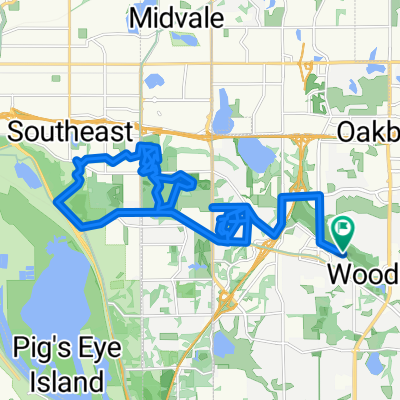
Hacia el norte por Radio Dr. Se convierte en Inwood Av. Siga Inwood hasta Stillwater Rd. Gire a la izquierda y vaya a Ideal. Gire a la derecha y siga Ideal hacia el norte. Se convierte en Olson Lake Rd. En 50th St. gire a la derecha hacia Demontreville Trail. Siga Demontreville a la izquierda alrededor del lago hasta Highlands Trail N hacia arriba de la colina. En la cima de la colina gire a la izquierda en Hytrail Av. N. A su izquierda estará la entrada al Gateway Trail. Tome el camino hacia abajo por la colina y a través de un pequeño bosque. Se curva y de repente está en la entrada del Gateway. Gire a la derecha y pase por el túnel bajo la carretera 36. Justo más allá del final del túnel hay una curva cerrada a la izquierda hasta un estacionamiento y hacia 60th St. N. Al final de esta carretera está Hilton Trail. Gire a la derecha y vaya a la siguiente esquina y gire a la izquierda en 62nd St. N. Vaya a Warner Rd. y gire a la derecha. Siga Warner Av. hacia el norte pasando Stillwater Rd. hasta que llegue a Locust St. Gire a la izquierda hacia Mahtomedi Av./244. Gire a la derecha en Mahtomedi y siga alrededor de White Bear Lake pasando el Yacht Club hasta que llegue a Highway 96/LakeAv. Gire a la izquierda y siga alrededor hasta que llegue a Northwest Av. Doble a la derecha en Northwest Av. hasta que llegue a Buffalo St. Gire a la izquierda y cruce la carretera 61. Justo cruzando las vías del tren gire a la izquierda en Hugo Rd. Siga la Hugo Rd. hasta que se curve a la derecha y se convierta en Park Av. Siga Park Av. hasta Bald Eagle Lake. Gire a la izquierda en Bald Eagle Blvd y rodee el lago hasta que llegue a Cty. Rd. H2. Gire a la izquierda en H2 y vaya hacia el oeste hasta que llegue a Centerville Rd. Gire a la derecha en Centerville Rd. y vaya hacia el norte hasta que llegue a Cty Rd. J. a la izquierda. Gire a la izquierda en Cty J y continúe en J hacia el oeste pasando Hodgson Rd./Lexington Av. y 35W. Siga hasta que llegue a Coral Sea St. Gire a la izquierda hacia su destino.
- -:--
- Duración
- 43,7 km
- Distancia
- 134 m
- Ascenso
- 164 m
- Descenso
- ---
- Velocidad Media
- 319 m
- Altitud máxima
Calidad de la ruta
Tipos de vía y superficies a lo largo de la ruta
Tipos de vía
Carretera
22,3 km
(51 %)
Carril bici
8,3 km
(19 %)
Superficies
Pavimentado
33,2 km
(76 %)
Asfalto
32,8 km
(75 %)
Pavimentado (sin definir)
0,4 km
(1 %)
Sin definir
10,5 km
(24 %)
Continuar con Bikemap
Usa, edita o descarga esta ruta en bici
¿Te gustaría recorrer B2B00248 55125>55112 viaRadio/Inwood/Ideal/OlsonLk/Demontr/WarnerRd/Lake/BaldEag/H2/Centv/CtyJ o personalizarla para tu propio viaje? Esto es lo que puedes hacer con esta ruta de Bikemap:
Funciones gratuitas
- Guarda esta ruta como favorita o en una colección
- Copia y planifica tu propia versión de esta ruta
- Sincroniza tu ruta con Garmin o Wahoo
Funciones Premium
Prueba gratuita de 3 días o pago único. Más información sobre Bikemap Premium.
- Navega esta ruta en iOS y Android
- Exporta un archivo GPX / KML de esta ruta
- Crea tu impresión personalizada (pruébala gratis)
- Descarga esta ruta para la navegación sin conexión
Descubre más funciones Premium.
Consigue Bikemap PremiumDe nuestra comunidad
Woodbury: Otras rutas populares que empiezan aquí
 B2B00288 55125>55344 via Mndt Hght Rd, 494, 86th St
- Distancia
- 46,8 km
- Ascenso
- 248 m
- Descenso
- 283 m
- Ubicación
- Woodbury, Minnesota, Estados Unidos
 IronMAN Relay Route
- Distancia
- 36,2 km
- Ascenso
- 190 m
- Descenso
- 190 m
- Ubicación
- Woodbury, Minnesota, Estados Unidos
 10870 Ashley Ln, Woodbury to 10869 Ashley Ln, Woodbury
- Distancia
- 28,9 km
- Ascenso
- 178 m
- Descenso
- 177 m
- Ubicación
- Woodbury, Minnesota, Estados Unidos
 Neighborhood loop
- Distancia
- 19,5 km
- Ascenso
- 114 m
- Descenso
- 113 m
- Ubicación
- Woodbury, Minnesota, Estados Unidos
 West to Battle Creek Park Ravine and back
- Distancia
- 34,2 km
- Ascenso
- 265 m
- Descenso
- 265 m
- Ubicación
- Woodbury, Minnesota, Estados Unidos
 North to Lake Elmo Park Reserve
- Distancia
- 33,2 km
- Ascenso
- 221 m
- Descenso
- 221 m
- Ubicación
- Woodbury, Minnesota, Estados Unidos
 Slow ride in Woodbury
- Distancia
- 7,8 km
- Ascenso
- 101 m
- Descenso
- 106 m
- Ubicación
- Woodbury, Minnesota, Estados Unidos
 South to Bailey Lake, Fairhaven, and beyond
- Distancia
- 36,5 km
- Ascenso
- 241 m
- Descenso
- 239 m
- Ubicación
- Woodbury, Minnesota, Estados Unidos
Ábrela en la app