

Stage 1
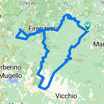
Una ruta en bici que comienza en Palazzuolo sul Senio, Región de Toscana, Italia.
Visión General
Sobre esta ruta
Una etapa entre el valle del Senio y el de Sintria, con tramos cortos y empinados en carreteras estrechas, descensos técnicos y caminos ásperos, frecuentemente recorridos durante el Giro d'Italia. Pasaremos por Brisighella, un pueblo de fortalezas y castillos, considerado uno de los lugares más bonitos de Italia. La tercera subida del día será la infame la Valletta, una carretera muy estrecha que sube por el lateral de la montaña en medio del cultivo de olivos y viñas, solo 2,7 kilómetros, pero ciertamente muy intensa. La pendiente media de casi el 10% con picos del 18-20% hace que este ascenso sea uno de los más exigentes de la zona, también debido a los largos tramos sin falsopiani intermedios. Ten cuidado, la carretera estrecha y las pendientes pronunciadas del 15-18% hacen que estos tres kilómetros sean desafiantes incluso en bajada. Una vez en Zattaglia, después de unos metros en una leve pendiente, empieza inmediatamente el ascenso al Monte Albano. (4.7 km con una pendiente media del 6% - bastante constante con tramos largos al 7% y dos picos ligeramente por encima del 8%.) Ahora hay 5 km de rápido descenso para llegar al puente sobre el río Senio en Casola Valsenio. Desde allí, tras unos cientos de metros, giramos a la izquierda en la carretera Lavanda, un ascenso de 5.6 km bastante constante, con pendientes que siempre son asequibles y prácticamente nunca superiores al 8%. Vía suficientemente ancha con curvas amplias, grandes vistas y una buena vista de la vena de yeso. Una vez en Prugno, una carretera estrecha de subidas y bajadas nos llevará de regreso a la carretera principal que nos conducirá de vuelta a Palazzuolo.
- -:--
- Duración
- 92,4 km
- Distancia
- 1568 m
- Ascenso
- 1568 m
- Descenso
- ---
- Velocidad Media
- ---
- Altitud máxima

Calidad de la ruta
Tipos de vía y superficies a lo largo de la ruta
Tipos de vía
Carretera tranquila
28,6 km
(31 %)
Carretera
26,8 km
(29 %)
Superficies
Pavimentado
74,8 km
(81 %)
Sin pavimentar
3,7 km
(4 %)
Asfalto
73,9 km
(80 %)
Grava
2,8 km
(3 %)
Continuar con Bikemap
Usa, edita o descarga esta ruta en bici
¿Te gustaría recorrer Stage 1 o personalizarla para tu propio viaje? Esto es lo que puedes hacer con esta ruta de Bikemap:
Funciones gratuitas
- Guarda esta ruta como favorita o en una colección
- Copia y planifica tu propia versión de esta ruta
- Divídelo en etapas para crear una excursión de varios días
- Sincroniza tu ruta con Garmin o Wahoo
Funciones Premium
Prueba gratuita de 3 días o pago único. Más información sobre Bikemap Premium.
- Navega esta ruta en iOS y Android
- Exporta un archivo GPX / KML de esta ruta
- Crea tu impresión personalizada (pruébala gratis)
- Descarga esta ruta para la navegación sin conexión
Descubre más funciones Premium.
Consigue Bikemap PremiumDe nuestra comunidad
Palazzuolo sul Senio: Otras rutas populares que empiezan aquí
 Palazzuolo-Marradi-Colla-Sambuca19/set/2015
- Distancia
- 46 km
- Ascenso
- 1123 m
- Descenso
- 1107 m
- Ubicación
- Palazzuolo sul Senio, Región de Toscana, Italia
 Palazzuolo-Marradi-Colla-Sambuca11/ago/2015
- Distancia
- 47 km
- Ascenso
- 1097 m
- Descenso
- 1102 m
- Ubicación
- Palazzuolo sul Senio, Región de Toscana, Italia
 Palazzuolo - Passo Futa
- Distancia
- 42,4 km
- Ascenso
- 1070 m
- Descenso
- 642 m
- Ubicación
- Palazzuolo sul Senio, Región de Toscana, Italia
 Palazzuolo-Marradi-Colla-Sambuca04/ago/2015
- Distancia
- 47 km
- Ascenso
- 1117 m
- Descenso
- 1111 m
- Ubicación
- Palazzuolo sul Senio, Región de Toscana, Italia
 Palazzuolo-Marradi-Colla-Sambuca08/ago/2015
- Distancia
- 46,7 km
- Ascenso
- 1101 m
- Descenso
- 1105 m
- Ubicación
- Palazzuolo sul Senio, Región de Toscana, Italia
 Quattro passi del mugello
- Distancia
- 118,4 km
- Ascenso
- 2338 m
- Descenso
- 2337 m
- Ubicación
- Palazzuolo sul Senio, Región de Toscana, Italia
 Palazzuolo-Marradi-Sambuca-Palazzuolo
- Distancia
- 46,7 km
- Ascenso
- 1112 m
- Descenso
- 1123 m
- Ubicación
- Palazzuolo sul Senio, Región de Toscana, Italia
 Stage 3
- Distancia
- 115,9 km
- Ascenso
- 1915 m
- Descenso
- 1933 m
- Ubicación
- Palazzuolo sul Senio, Región de Toscana, Italia
Ábrela en la app