

Circumnavigate Edmonds Bay/Stoney Creek
Una ruta en bici que comienza en Fennell Bay, Nueva Gales del Sur, Australia.
Visión General
Sobre esta ruta
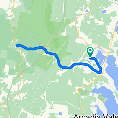
Sal de la Escuela Pública Blackalls Park por su entrada en la esquina de las calles Rupert y Todd y viaja al noreste por Rupert.
En la esquina de la calle Rupert y South Parade, cruza con cuidado en diagonal hacia Rose Street (Este) y recorre 100 metros hasta el Greenway-Cycleway.
Sigue el Greenway-Cycleway hacia el norte hasta el pueblo de Fassifern. En la intersección para la estación de tren de Fassifern, viaja unos metros hacia el este y entra en Awaba Street.
En Awaba Street, viaja hacia el norte y cruza el puente hacia Bridge Street, Fassifern, y continúa hacia el noroeste hasta la intersección con Macquarie Road.
Gira a la derecha en Macquarie Road y viaja aproximadamente 1.5 km hasta Brougham Ave (generalmente hacia el sureste la mayor parte del trayecto).
Gira a la derecha por Brougham Ave (sur) y luego a la izquierda en Edwards Street... cruzando cuidadosamente CINCO calles hasta unirte a la carretera principal sobre el puente de Fennell Bay y luego 1200 metros hasta Day Street.
Gira a la izquierda en Day Street y avanza 50 m, desviándote suavemente hacia Renwick Street. Son poco menos de 600 m hasta girar a la derecha en Bay Street pasando el McDonald's Toronto mientras vuelves a la carretera principal.
Cruza la carretera principal con seguridad en el semáforo y luego avanza 100 m hacia el SUR hasta el punto de entrada del Greenway-Cycleway frente a la intersección con Victory Parade.
Permanece en el Greenway unos 1750 metros (viajando generalmente hacia el NOROESTE) hasta que veas la salida para Todd Street.
Cruza con cuidado la carretera principal y viaja hacia el oeste por Todd Street unos 400 metros hasta donde comenzaste esta ruta.
- -:--
- Duración
- 9,2 km
- Distancia
- 54 m
- Ascenso
- 63 m
- Descenso
- ---
- Velocidad Media
- ---
- Altitud máxima

Continuar con Bikemap
Usa, edita o descarga esta ruta en bici
¿Te gustaría recorrer Circumnavigate Edmonds Bay/Stoney Creek o personalizarla para tu propio viaje? Esto es lo que puedes hacer con esta ruta de Bikemap:
Funciones gratuitas
- Guarda esta ruta como favorita o en una colección
- Copia y planifica tu propia versión de esta ruta
- Sincroniza tu ruta con Garmin o Wahoo
Funciones Premium
Prueba gratuita de 3 días o pago único. Más información sobre Bikemap Premium.
- Navega esta ruta en iOS y Android
- Exporta un archivo GPX / KML de esta ruta
- Crea tu impresión personalizada (pruébala gratis)
- Descarga esta ruta para la navegación sin conexión
Descubre más funciones Premium.
Consigue Bikemap PremiumDe nuestra comunidad
Fennell Bay: Otras rutas populares que empiezan aquí
 Random Ride South of Fennell Bay Bridge
- Distancia
- 16,4 km
- Ascenso
- 103 m
- Descenso
- 135 m
- Ubicación
- Fennell Bay, Nueva Gales del Sur, Australia
 Macca's coffee run - 7.5+ km round-trip
- Distancia
- 8 km
- Ascenso
- 65 m
- Descenso
- 70 m
- Ubicación
- Fennell Bay, Nueva Gales del Sur, Australia
 Toronto Pool (short) + Back Home (long)
- Distancia
- 12,1 km
- Ascenso
- 109 m
- Descenso
- 106 m
- Ubicación
- Fennell Bay, Nueva Gales del Sur, Australia
 Toronto High School, Coles, home
- Distancia
- 16,7 km
- Ascenso
- 84 m
- Descenso
- 88 m
- Ubicación
- Fennell Bay, Nueva Gales del Sur, Australia
 Lapped Fennell Bay & Edmunds Bay + Toronto Shops
- Distancia
- 11,2 km
- Ascenso
- 87 m
- Descenso
- 85 m
- Ubicación
- Fennell Bay, Nueva Gales del Sur, Australia
 Blackalls Park Public School to Toronto Pool +
- Distancia
- 10,5 km
- Ascenso
- 67 m
- Descenso
- 66 m
- Ubicación
- Fennell Bay, Nueva Gales del Sur, Australia
 BPPS to Freemans Waterhole Subway
- Distancia
- 28,6 km
- Ascenso
- 197 m
- Descenso
- 197 m
- Ubicación
- Fennell Bay, Nueva Gales del Sur, Australia
 Blackalls Park - THS - Toronto - home - 10.5km
- Distancia
- 10,7 km
- Ascenso
- 81 m
- Descenso
- 80 m
- Ubicación
- Fennell Bay, Nueva Gales del Sur, Australia
Ábrela en la app