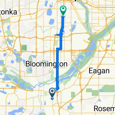
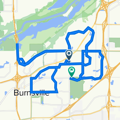
B2B00357 55337>55403 via High Line Trl, Pilot Knob Rd, Mendota Bridge, Hiawatha Trl
Una ruta en bici que comienza en Burnsville, Minnesota, United States of America.
Visión General
Sobre esta ruta
This route gives plenty of options since the distance is so long. The route mapped relies mostly on bike paths and trails. Pilot Knob has paths on both sides of the road but caution should be taken as the path crosses busy intersections and driveways.
The path continues through Ft Snelling and up onto the Hiawatha Trail, where you will ride next to the light rail practically to downtown.
If traffic is not a concern, it would be possible to take Sibley Hwy (13) to the Mendota bridge, but you would have to rely on a shoulder.
Another option is to take the light rail from the 494 bridge crossing. The crossing ends in a cul-de-sac where you can get on the road (E 80th/American Blvd) and follow the road to a stop light. If you take a left onto 34th Ave/Old Shakopee there will be a path to get to a light rail station.
- -:--
- Duración
- 35,3 km
- Distancia
- 212 m
- Ascenso
- 230 m
- Descenso
- ---
- Velocidad Media
- ---
- Altitud máxima
Destacados de la ruta
Puntos de interés a lo largo de la ruta
Punto de interés después de 16 km
494 path to light rail station
Punto de interés después de 16,9 km
Continue on path to light rail station
Punto de interés después de 16,9 km
Light Rail station
Continuar con Bikemap
Usa, edita o descarga esta ruta en bici
¿Te gustaría recorrer B2B00357 55337>55403 via High Line Trl, Pilot Knob Rd, Mendota Bridge, Hiawatha Trl o personalizarla para tu propio viaje? Esto es lo que puedes hacer con esta ruta de Bikemap:
Funciones gratuitas
- Guarda esta ruta como favorita o en una colección
- Copia y planifica tu propia versión de esta ruta
- Sincroniza tu ruta con Garmin o Wahoo
Funciones Premium
Prueba gratuita de 3 días o pago único. Más información sobre Bikemap Premium.
- Navega esta ruta en iOS y Android
- Exporta un archivo GPX / KML de esta ruta
- Crea tu impresión personalizada (pruébala gratis)
- Descarga esta ruta para la navegación sin conexión
Descubre más funciones Premium.
Consigue Bikemap PremiumDe nuestra comunidad
Burnsville: Otras rutas populares que empiezan aquí
- B2B00357 55337>55403 via High Line Trl, Pilot Knob Rd, Mendota Bridge, Hiawatha Trl
- Distancia
- 35,3 km
- Ascenso
- 212 m
- Descenso
- 230 m
- Ubicación
- Burnsville, Minnesota, United States of America
- Cleary Lake Campground - Prior Lake, Mn
- Distancia
- 15,7 km
- Ascenso
- 78 m
- Descenso
- 76 m
- Ubicación
- Burnsville, Minnesota, United States of America
- Cannon Falls Lake Billsbey
- Distancia
- 48,6 km
- Ascenso
- 102 m
- Descenso
- 130 m
- Ubicación
- Burnsville, Minnesota, United States of America
- B2B00098 55337>55424 via Ferry Brg, McCauley
- Distancia
- 33,8 km
- Ascenso
- 156 m
- Descenso
- 132 m
- Ubicación
- Burnsville, Minnesota, United States of America
- Awesome training ride
- Distancia
- 32,9 km
- Ascenso
- 177 m
- Descenso
- 174 m
- Ubicación
- Burnsville, Minnesota, United States of America
- B2B00477 55337>55144 via High Line Trl, Deerwood Dr, Wescott Rd, Delaware Rd, Charlton St
- Distancia
- 42,2 km
- Ascenso
- 276 m
- Descenso
- 256 m
- Ubicación
- Burnsville, Minnesota, United States of America
- B2B00753 55337>55102 via Rvrs Hills Dr, Bg Rvrs Trl
- Distancia
- 32,6 km
- Ascenso
- 188 m
- Descenso
- 205 m
- Ubicación
- Burnsville, Minnesota, United States of America
- B2B00769 55337>55102 via High Line Trl, Pilot Knob, Victoria Rd, Shepard Rd
- Distancia
- 25,2 km
- Ascenso
- 100 m
- Descenso
- 170 m
- Ubicación
- Burnsville, Minnesota, United States of America
Ábrela en la app