

Road cycling. Val d'Aran - Pyrenees: Tour Vielha with Superbagneres
Una ruta en bici que comienza en Les, Comunidad Autónoma de Cataluña, España.
Visión General
Sobre esta ruta
Esta ruta comienza en Bossòst, pero también podría servir fácilmente para ciclistas que se alojen en Vielha, quienes podrían llegar a Bossòst por los amplios arcénes de la N-230.
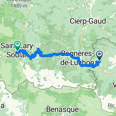
Comenzamos en Bossòst, saliendo del pueblo por el sur, a lo largo del río Garona, y subiendo cuesta arriba, justo en la rotonda, por la N-141. Este es el comienzo del Portilhon, el puerto que marca la frontera entre España y Francia. Empieza con una serie de revueltas que ofrecen grandes vistas de Bossòst, pasa por el Parque de Arán y, después de cruzar la frontera en la cima, baja rápidamente hacia Francia.
En Saint-Mamet, si tienes buenas piernas, sigue la ruta GPS hacia la izquierda después de cruzar el río Pique, para dirigirte hacia la subida a Superbagnères. Esta subida es un camino sin salida, lo que significa que subirás hasta la cima y volverás a este punto. Por lo tanto, si prefieres no hacerla, gira a la derecha después de cruzar el río Pique y continúa a través de Bagnères de Luchon.
Si decides subir a Superbagnères, la pendiente aumenta bastante pronto después de salir de Saint-Mamet, incluyendo rampas del 12% en los primeros dos kilómetros. La subida total es de 18,5 kilómetros y está destinada a ciclistas expertos. El ascenso total es de 1170 m, llegando a más de 1800 m de altitud, con una pendiente media del 6,3%. Finalmente dejarás la línea de árboles atrás, y el paisaje se abre a amplias praderas de alta montaña, con vistas a muchos de los picos nevados de 3000 m de la región. Una vez llegues a la estación de esquí en la cima, solo te queda regresar y disfrutar del descenso hasta Bagnères-de-Luchon.
La ruta ahora atraviesa Bagnères-de-Luchon de sur a norte, luego sigue el río Pique por la D125 hasta Gaud, donde giramos a la derecha en la rotonda y nos unimos a la D44 en dirección a Marignac. La D44 es una carretera lo suficientemente fácil, subiendo muy suavemente después de Marignac. Llegamos al valle del río Garona y giramos a la derecha en la N125, que continúa subiendo suavemente, a lo largo del valle del río, hacia la frontera española.
Puntos de interés: La subida a Superbagnères es una ruta de peregrinación para los fanáticos del Tour de Francia, que han presenciado muchas batallas famosas entre los mejores ciclistas del mundo en sus rampas. Es una zona muy salvaje, y hay bonitas vistas (y sonidos) del río Lys que cae junto a la carretera, a lo largo de la ruta.
- -:--
- Duración
- 90,2 km
- Distancia
- 2386 m
- Ascenso
- 2386 m
- Descenso
- ---
- Velocidad Media
- ---
- Altitud máxima

Calidad de la ruta
Tipos de vía y superficies a lo largo de la ruta
Tipos de vía
Carretera
33,4 km
(37 %)
Carretera tranquila
1,8 km
(2 %)
Superficies
Pavimentado
46,9 km
(52 %)
Asfalto
46,9 km
(52 %)
Sin definir
43,3 km
(48 %)
Continuar con Bikemap
Usa, edita o descarga esta ruta en bici
¿Te gustaría recorrer Road cycling. Val d'Aran - Pyrenees: Tour Vielha with Superbagneres o personalizarla para tu propio viaje? Esto es lo que puedes hacer con esta ruta de Bikemap:
Funciones gratuitas
- Guarda esta ruta como favorita o en una colección
- Copia y planifica tu propia versión de esta ruta
- Divídelo en etapas para crear una excursión de varios días
- Sincroniza tu ruta con Garmin o Wahoo
Funciones Premium
Prueba gratuita de 3 días o pago único. Más información sobre Bikemap Premium.
- Navega esta ruta en iOS y Android
- Exporta un archivo GPX / KML de esta ruta
- Crea tu impresión personalizada (pruébala gratis)
- Descarga esta ruta para la navegación sin conexión
Descubre más funciones Premium.
Consigue Bikemap PremiumDe nuestra comunidad
Les: Otras rutas populares que empiezan aquí
 Bossot-Portillon-Peyragudes-Val Louron-Saint Lary Soulan
- Distancia
- 62,4 km
- Ascenso
- 2168 m
- Descenso
- 2057 m
- Ubicación
- Les, Comunidad Autónoma de Cataluña, España
 PIRINEOS MÍTICOS 2020
- Distancia
- 386,7 km
- Ascenso
- 14.434 m
- Descenso
- 14.347 m
- Ubicación
- Les, Comunidad Autónoma de Cataluña, España
 Bossost 2
- Distancia
- 115 km
- Ascenso
- 2516 m
- Descenso
- 2512 m
- Ubicación
- Les, Comunidad Autónoma de Cataluña, España
 Road Cycling: Aran - Haute Garonne Loop
- Distancia
- 136,4 km
- Ascenso
- 4122 m
- Descenso
- 4121 m
- Ubicación
- Les, Comunidad Autónoma de Cataluña, España
 Gravel Bike /MTB. Val d'Aran - Pyrenees: Vall de Toran: Les | Pista Portet | Honeria | Canejan | Les
- Distancia
- 36,8 km
- Ascenso
- 1211 m
- Descenso
- 1214 m
- Ubicación
- Les, Comunidad Autónoma de Cataluña, España
 bossost
- Distancia
- 117,8 km
- Ascenso
- 2223 m
- Descenso
- 2223 m
- Ubicación
- Les, Comunidad Autónoma de Cataluña, España
 Pombair Tour 2012, 6. Tag
- Distancia
- 96,8 km
- Ascenso
- 1617 m
- Descenso
- 1641 m
- Ubicación
- Les, Comunidad Autónoma de Cataluña, España
 Road cycling. Val d'Aran - Pyrenees: Tour Vielha with Superbagneres
- Distancia
- 90,2 km
- Ascenso
- 2386 m
- Descenso
- 2386 m
- Ubicación
- Les, Comunidad Autónoma de Cataluña, España
Ábrela en la app