

Brainerd loop for Sue's group of 12
Una ruta en bici que comienza en Brainerd, Minnesota, Estados Unidos.
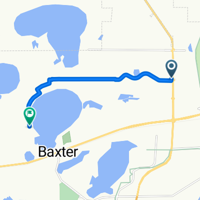
Visión General
Sobre esta ruta
Reúnanse en el inicio del sendero y en el aparcamiento ubicados en el Northland Arboretum.
Salgan hacia el oeste por el conector del sendero Paul Bunyan.
Tomen a la izquierda en el sendero Paul Bunyan y vayan hacia el sur, sobre el puente cruzando Excelsior Dr y pasando por un paso bajo la autopista estatal 210.
Giren a la derecha en la intersección en 'T' del sendero y vayan hacia el oeste. A poca distancia llegará a la intersección con Cypress Drive. Sigan el sendero tomando a la derecha (sur). Están paralelos a la recién construida Cypress Dr en un sendero recién pavimentado.
Manténganse en el sendero pavimentado, girando a la izquierda. Ahora van paralelos a South College Rd. El sendero pasa fácilmente por varias rotondas en este largo tramo. Este tramo termina al cruzar el río Mississippi.
Una vez cruzado el río, el sendero continúa hacia el este, a lo largo de East College Dr. hasta la siguiente rotonda. Evitarán la rotonda permaneciendo en el sendero y subiendo una colina pasando por la escuela secundaria Brainerd en construcción. Van hacia el norte por South 5th St.
Tomen a la derecha en el sendero pavimentado del lado sur de Oak Street.
Manténganse en el sendero pavimentado de Oak Street hasta cruzar 8th St. Luego sigan el sendero hacia el norte a lo largo de 8th durante 3 cuadras.
Giren a la izquierda (oeste) en Laurel Street aproximadamente por 2 cuadras hasta llegar a Sage on Laurel (lado izquierdo/sur de Laurel), donde almorzarán. Dejen las bicicletas en el aparcamiento o alrededor del área de asientos al aire libre.
Después del almuerzo, regresen hacia el este por Laurel hasta el sendero en South 8th.
Tomen a la izquierda en el sendero de South 8th y vayan hacia el norte por aproximadamente 2 cuadras.
Crucen Washington St/Hwy 210 en el cruce.
Una vez cruzado Washington St./Hwy 210, giren inmediatamente a la izquierda por dos cuadras hasta llegar a un sendero en la intersección con North 10th (un pequeño triángulo tipo parque con un sendero que lleva a un gran estacionamiento del Franklin Arts Center).
Continúen a través del estacionamiento del Franklin Arts Center, cruzando Kingwood Street donde el sendero retoma claramente.
Continúen hacia el oeste hasta la destilería 5Rocks, ubicada en la esquina de 1st Ave. NE y Washington/Hwy 210.
¡Tomen una bebida!
Regresen por el mismo camino de vuelta al inicio del sendero en el Arboretum.
- -:--
- Duración
- 13,6 km
- Distancia
- 67 m
- Ascenso
- 67 m
- Descenso
- ---
- Velocidad Media
- ---
- Altitud máxima

Destacados de la ruta
Puntos de interés a lo largo de la ruta
Punto de interés después de 0 km
Northland Arboretum Parking and Trail-head. Starting Point

Punto de interés después de 6,1 km
Sage on Laurel - Lunch

Punto de interés después de 7,3 km
5Rocks Distilling
Continuar con Bikemap
Usa, edita o descarga esta ruta en bici
¿Te gustaría recorrer Brainerd loop for Sue's group of 12 o personalizarla para tu propio viaje? Esto es lo que puedes hacer con esta ruta de Bikemap:
Funciones gratuitas
- Guarda esta ruta como favorita o en una colección
- Copia y planifica tu propia versión de esta ruta
- Sincroniza tu ruta con Garmin o Wahoo
Funciones Premium
Prueba gratuita de 3 días o pago único. Más información sobre Bikemap Premium.
- Navega esta ruta en iOS y Android
- Exporta un archivo GPX / KML de esta ruta
- Crea tu impresión personalizada (pruébala gratis)
- Descarga esta ruta para la navegación sin conexión
Descubre más funciones Premium.
Consigue Bikemap PremiumDe nuestra comunidad
Brainerd: Otras rutas populares que empiezan aquí
 Recovered Route
- Distancia
- 21,6 km
- Ascenso
- 108 m
- Descenso
- 101 m
- Ubicación
- Brainerd, Minnesota, Estados Unidos
 Spred Out Morning Ride In Brainerd
- Distancia
- 33,9 km
- Ascenso
- 331 m
- Descenso
- 327 m
- Ubicación
- Brainerd, Minnesota, Estados Unidos
 Kirkwood Ln, Baxter to Travine Dr, Baxter
- Distancia
- 5,8 km
- Ascenso
- 7 m
- Descenso
- 4 m
- Ubicación
- Brainerd, Minnesota, Estados Unidos
 GULL-QEQUOT-BREEZY-HOME
- Distancia
- 95,2 km
- Ascenso
- 190 m
- Descenso
- 198 m
- Ubicación
- Brainerd, Minnesota, Estados Unidos
 Brainerd loop for Sue's group of 12
- Distancia
- 13,6 km
- Ascenso
- 67 m
- Descenso
- 67 m
- Ubicación
- Brainerd, Minnesota, Estados Unidos
 Lake Tour
- Distancia
- 68,7 km
- Ascenso
- 196 m
- Descenso
- 195 m
- Ubicación
- Brainerd, Minnesota, Estados Unidos
 Paul Bunyan Trail
- Distancia
- 152,5 km
- Ascenso
- 186 m
- Descenso
- 138 m
- Ubicación
- Brainerd, Minnesota, Estados Unidos
 510 Laurel St, Brainerd to 301 Minnesota Ave W, Walker
- Distancia
- 101,6 km
- Ascenso
- 159 m
- Descenso
- 122 m
- Ubicación
- Brainerd, Minnesota, Estados Unidos
Ábrela en la app