

Cleish Hill twice > Gleneagles loop 59
Una ruta en bici que comienza en Kelty, Escocia, Reino Unido.
Visión General
Sobre esta ruta
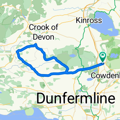
Un agradable recorrido con buenas subidas y bajadas explorando los límites de Kinross y Perthshire.
- Comienza en el borde de Kelty, con tiendas y cafés cerca. Dirígete hacia el oeste.
- Gira para ascender y descender Cleish Hill, gran vista sobre Kinross y Loch Leven hasta las Lomond Hills al este.
- Toma carreteras planas hacia Kinross, Milnathort y luego al este hacia el desvío de Glenfarg (Beinn Inn).
- Sigue un estrecho desfiladero entre colinas pasando Glenfarg y luego bajando entre árboles (escénico y fácil de pedalear) pasando el Beinn Inn hacia el valle plano que rodea Bridge of Earn (hay tiendas aquí).
- Continúa por caminos secundarios pasando Strathallan, Forteviot y Dunning. Todos pintorescos, con opciones de comida en Dunning. Los caminos secundarios continúan hacia Gleneagles, evitando Auchterarder.
- Sube sobre Glen Eagles, se siente más difícil de lo que indica el mapa. Avanza rápidamente por las colinas hacia Glendevon y las puertas de Muckhart.
- En la intersección gira a la izquierda y sigue por carreteras relativamente planas hacia Drum, luego Cleish y regresa sobre Cleish Hill en dirección opuesta (bastante duro).
- Es posible una ruta alternativa de regreso a Kelty sin colinas a través de Blairadam.
- -:--
- Duración
- 95,8 km
- Distancia
- 649 m
- Ascenso
- 649 m
- Descenso
- ---
- Velocidad Media
- ---
- Altitud máxima
Calidad de la ruta
Tipos de vía y superficies a lo largo de la ruta
Tipos de vía
Carretera tranquila
24 km
(25 %)
Carretera
6,7 km
(7 %)
Superficies
Pavimentado
51,8 km
(54 %)
Asfalto
50,8 km
(53 %)
Pavimentado (sin definir)
1 km
(1 %)
Sin definir
44,1 km
(46 %)
Continuar con Bikemap
Usa, edita o descarga esta ruta en bici
¿Te gustaría recorrer Cleish Hill twice > Gleneagles loop 59 o personalizarla para tu propio viaje? Esto es lo que puedes hacer con esta ruta de Bikemap:
Funciones gratuitas
- Guarda esta ruta como favorita o en una colección
- Copia y planifica tu propia versión de esta ruta
- Divídelo en etapas para crear una excursión de varios días
- Sincroniza tu ruta con Garmin o Wahoo
Funciones Premium
Prueba gratuita de 3 días o pago único. Más información sobre Bikemap Premium.
- Navega esta ruta en iOS y Android
- Exporta un archivo GPX / KML de esta ruta
- Crea tu impresión personalizada (pruébala gratis)
- Descarga esta ruta para la navegación sin conexión
Descubre más funciones Premium.
Consigue Bikemap PremiumDe nuestra comunidad
Kelty: Otras rutas populares que empiezan aquí
 KCC GP Cleish 10m 2023
- Distancia
- 16 km
- Ascenso
- 40 m
- Descenso
- 46 m
- Ubicación
- Kelty, Escocia, Reino Unido
 Kelty Saline Powmill Knockhill Kelty
- Distancia
- 39,3 km
- Ascenso
- 408 m
- Descenso
- 408 m
- Ubicación
- Kelty, Escocia, Reino Unido
 GVAP Rawhide Charity Cycle #2
- Distancia
- 50,5 km
- Ascenso
- 292 m
- Descenso
- 333 m
- Ubicación
- Kelty, Escocia, Reino Unido
 Round The Lochs
- Distancia
- 33,7 km
- Ascenso
- 179 m
- Descenso
- 179 m
- Ubicación
- Kelty, Escocia, Reino Unido
 Cleish Hill twice > Gleneagles loop 59
- Distancia
- 95,8 km
- Ascenso
- 649 m
- Descenso
- 649 m
- Ubicación
- Kelty, Escocia, Reino Unido
 Kelty Saline Powmill Cleish Kelty
- Distancia
- 42,4 km
- Ascenso
- 440 m
- Descenso
- 440 m
- Ubicación
- Kelty, Escocia, Reino Unido
 Hilly loop
- Distancia
- 64,8 km
- Ascenso
- 688 m
- Descenso
- 688 m
- Ubicación
- Kelty, Escocia, Reino Unido
 Route from B914, Kelty
- Distancia
- 4,8 km
- Ascenso
- 132 m
- Descenso
- 148 m
- Ubicación
- Kelty, Escocia, Reino Unido
Ábrela en la app