

Wollomombi circuit
Una ruta en bici que comienza en Armidale, Nueva Gales del Sur, Australia.
Visión General
Sobre esta ruta
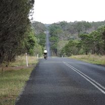
This circuit from Armidale to Wollomombi falls and back via Hillgrove and Bakers creek falls could be undertaken in one longish day. Instead, we chose to take our tent and a barbecue tea and camped out in the National Park. This meant that we not only had a leisurely ride in both directions, but we were able to experience much more of the park. We saw a squirrel glider and a couple of squabbling possums as we cooked our barbecue at Edgars lookout while the sun set colours lit up the sky in one direction and the full moon rose in the other direction. Later we rode our bikes around to the main lookout to photograph the gorge by moonlight, seeing a bonus brush tailed rock wallaby as well as an owl. While eating breakfast we watched and listened to the resident lyrebird displaying. The route is a hilly one, the seal runs out about 7 km along Chandler rd and the road is gravel until Kilcoy rd meets Fassifern rd nearly at Wollomombi village. We returned via Waterfall Way. This is a highway with a fairly low volume of fast traffic. It has a shoulder much of the way, but this is usually very narrow. So, it’s OK to ride but not that pleasant. We took a detour off the main road to visit the old mining village of Hillgrove, as well as Baker’s creek falls. This was mostly a pleasant ride though old Hillgrove rd was pretty corrugated and rough. It also misses one of the narrower sections of the highway.
- -:--
- Duración
- 110,6 km
- Distancia
- 1722 m
- Ascenso
- 1721 m
- Descenso
- ---
- Velocidad Media
- 1113 m
- Altitud máxima

Fotos de la ruta


Calidad de la ruta
Tipos de vía y superficies a lo largo de la ruta
Tipos de vía
Carretera
54,4 km
(49 %)
Carretera concurrida
28,3 km
(26 %)
Superficies
Pavimentado
75,1 km
(68 %)
Sin pavimentar
34,2 km
(31 %)
Asfalto
72,2 km
(65 %)
Sin asfaltar (sin definir)
32,3 km
(29 %)
Continuar con Bikemap
Usa, edita o descarga esta ruta en bici
¿Te gustaría recorrer Wollomombi circuit o personalizarla para tu propio viaje? Esto es lo que puedes hacer con esta ruta de Bikemap:
Funciones gratuitas
- Guarda esta ruta como favorita o en una colección
- Copia y planifica tu propia versión de esta ruta
- Divídelo en etapas para crear una excursión de varios días
- Sincroniza tu ruta con Garmin o Wahoo
Funciones Premium
Prueba gratuita de 3 días o pago único. Más información sobre Bikemap Premium.
- Navega esta ruta en iOS y Android
- Exporta un archivo GPX / KML de esta ruta
- Crea tu impresión personalizada (pruébala gratis)
- Descarga esta ruta para la navegación sin conexión
Descubre más funciones Premium.
Consigue Bikemap PremiumDe nuestra comunidad
Armidale: Otras rutas populares que empiezan aquí
 Flat White
- Distancia
- 19,5 km
- Ascenso
- 203 m
- Descenso
- 201 m
- Ubicación
- Armidale, Nueva Gales del Sur, Australia
 Kelly's plains circuit
- Distancia
- 19,5 km
- Ascenso
- 179 m
- Descenso
- 179 m
- Ubicación
- Armidale, Nueva Gales del Sur, Australia
 Apple tree drive loop for kids
- Distancia
- 7,8 km
- Ascenso
- 92 m
- Descenso
- 93 m
- Ubicación
- Armidale, Nueva Gales del Sur, Australia
 Avoiding the Waterfall Way from Armidale
- Distancia
- 92,5 km
- Ascenso
- 708 m
- Descenso
- 708 m
- Ubicación
- Armidale, Nueva Gales del Sur, Australia
 Armidale to Point Lookout loop
- Distancia
- 226,3 km
- Ascenso
- 4225 m
- Descenso
- 4225 m
- Ubicación
- Armidale, Nueva Gales del Sur, Australia
 Armidale to Uralla via Arding
- Distancia
- 54,5 km
- Ascenso
- 405 m
- Descenso
- 396 m
- Ubicación
- Armidale, Nueva Gales del Sur, Australia
 Armidale to Gara river crossing along Herbert Park Rd
- Distancia
- 48,3 km
- Ascenso
- 516 m
- Descenso
- 515 m
- Ubicación
- Armidale, Nueva Gales del Sur, Australia
 Armidale to Uralla via Hawthorne Dr
- Distancia
- 72,4 km
- Ascenso
- 463 m
- Descenso
- 464 m
- Ubicación
- Armidale, Nueva Gales del Sur, Australia
Ábrela en la app