

Bury St Edmunds Hilly Loop
Una ruta en bici que comienza en Bury St Edmunds, Inglaterra, Reino Unido.
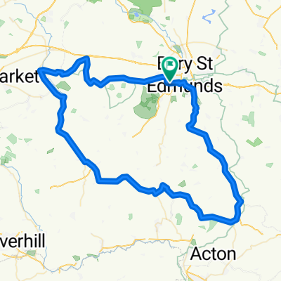
Visión General
Sobre esta ruta
The first part of the route is one of the hilliest in Suffolk. Hartest Hill is the steepest. The route takes you down country roads through Lavenham and Bildeston before heading north through Ringshall to Stowmarket.
Go straight through the centre of Stowmarket and once out of Stowmarket follow the cycle path alongside the A14 to Haughley New Street. Although this cycle path is unpleasant and contains broken glass and some waste it would be suicidal going on the A14. Then follow the villages back into Stowmarket. There is a cycle path to the left just before you get into Bury. This cycle path is a lot nicer and gets you off the busy main road entering Bury.
If you do have problems then there are plenty of regular trains in the villages between Stowmarket and Bury.
- -:--
- Duración
- 109,2 km
- Distancia
- 397 m
- Ascenso
- 401 m
- Descenso
- ---
- Velocidad Media
- ---
- Altitud máxima
Calidad de la ruta
Tipos de vía y superficies a lo largo de la ruta
Tipos de vía
Carretera
47,8 km
(44 %)
Carretera concurrida
34,8 km
(32 %)
Superficies
Pavimentado
10,8 km
(10 %)
Sin pavimentar
0,2 km
(<1 %)
Asfalto
9,9 km
(9 %)
Pavimentado (sin definir)
0,7 km
(<1 %)
Continuar con Bikemap
Usa, edita o descarga esta ruta en bici
¿Te gustaría recorrer Bury St Edmunds Hilly Loop o personalizarla para tu propio viaje? Esto es lo que puedes hacer con esta ruta de Bikemap:
Funciones gratuitas
- Guarda esta ruta como favorita o en una colección
- Copia y planifica tu propia versión de esta ruta
- Divídelo en etapas para crear una excursión de varios días
- Sincroniza tu ruta con Garmin o Wahoo
Funciones Premium
Prueba gratuita de 3 días o pago único. Más información sobre Bikemap Premium.
- Navega esta ruta en iOS y Android
- Exporta un archivo GPX / KML de esta ruta
- Crea tu impresión personalizada (pruébala gratis)
- Descarga esta ruta para la navegación sin conexión
Descubre más funciones Premium.
Consigue Bikemap PremiumDe nuestra comunidad
Bury St Edmunds: Otras rutas populares que empiezan aquí
 Wherstead circuit
- Distancia
- 17,6 km
- Ascenso
- 130 m
- Descenso
- 130 m
- Ubicación
- Bury St Edmunds, Inglaterra, Reino Unido
 Kentford Circular
- Distancia
- 48,8 km
- Ascenso
- 240 m
- Descenso
- 239 m
- Ubicación
- Bury St Edmunds, Inglaterra, Reino Unido
 BURY-LAVENHAM-WICKHAMBROOK-MOULTON-BURY
- Distancia
- 75 km
- Ascenso
- 354 m
- Descenso
- 354 m
- Ubicación
- Bury St Edmunds, Inglaterra, Reino Unido
 10km ride
- Distancia
- 9,6 km
- Ascenso
- 54 m
- Descenso
- 49 m
- Ubicación
- Bury St Edmunds, Inglaterra, Reino Unido
 5k for nhs
- Distancia
- 50,5 km
- Ascenso
- 162 m
- Descenso
- 159 m
- Ubicación
- Bury St Edmunds, Inglaterra, Reino Unido
 BURY-LAVENHAM-WICKHAMBROOK-MOULTON-BURY
- Distancia
- 75 km
- Ascenso
- 358 m
- Descenso
- 358 m
- Ubicación
- Bury St Edmunds, Inglaterra, Reino Unido
 tour de bury smol
- Distancia
- 37 km
- Ascenso
- 145 m
- Descenso
- 144 m
- Ubicación
- Bury St Edmunds, Inglaterra, Reino Unido
 Suffolk Cycle One
- Distancia
- 48,4 km
- Ascenso
- 0 m
- Descenso
- 0 m
- Ubicación
- Bury St Edmunds, Inglaterra, Reino Unido
Ábrela en la app