
Rochester à vélo
Découvre une carte de 46 itinéraires et pistes cyclables près de Rochester, créés par notre communauté.
Portrait de région
Fais connaissance avec Rochester
Trouve l’itinéraire à vélo qui te convient à Rochester, où nous avons 46 pistes cyclables à explorer.
2 360 km
Distance enregistrée
46
Itinéraires cyclables
Communauté
Utilisateurs les plus actifs à Rochester


De notre communauté
Les meilleurs itinéraires à vélo dans et autour de Rochester

Periple 11 / 28
Itinéraire à vélo à Rochester, Angleterre, Royaume-Uni
- 167,7 km
- Distance
- 1 250 m
- Montée
- 1 182 m
- Descente

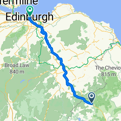
BfCiC recce
Itinéraire à vélo à Rochester, Angleterre, Royaume-Uni
- 214,8 km
- Distance
- 940 m
- Montée
- 1 119 m
- Descente

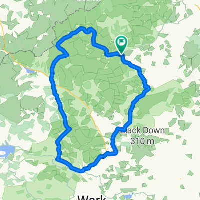
Kielder észak
Itinéraire à vélo à Rochester, Angleterre, Royaume-Uni
- 17,1 km
- Distance
- 178 m
- Montée
- 185 m
- Descente

Kielder Water
Itinéraire à vélo à Rochester, Angleterre, Royaume-Uni
- 48,4 km
- Distance
- 444 m
- Montée
- 444 m
- Descente
Découvrez plus d'itinéraires
 8 Otterburn Green, Newcastle Upon Tyne to Foundry Farm, Hexham
- Distance
- 30,6 km
- Montée
- 363 m
- Descente
- 465 m
- Emplacement
- Rochester, Angleterre, Royaume-Uni

Edge810®
Rochester Radfahren- Distance
- 39,8 km
- Montée
- 514 m
- Descente
- 512 m
- Emplacement
- Rochester, Angleterre, Royaume-Uni
 LEJOG - Day 10
- Distance
- 112,6 km
- Montée
- 921 m
- Descente
- 1 112 m
- Emplacement
- Rochester, Angleterre, Royaume-Uni

Edge810®
Rochester Cycling- Distance
- 9,7 km
- Montée
- 161 m
- Descente
- 155 m
- Emplacement
- Rochester, Angleterre, Royaume-Uni

Edge810®
Rochester Cycling- Distance
- 40,1 km
- Montée
- 519 m
- Descente
- 522 m
- Emplacement
- Rochester, Angleterre, Royaume-Uni
 Lew and Cal round Kielder
- Distance
- 41,6 km
- Montée
- 253 m
- Descente
- 253 m
- Emplacement
- Rochester, Angleterre, Royaume-Uni
 Pt9 THE FINAL DAY
- Distance
- 93,5 km
- Montée
- 509 m
- Descente
- 675 m
- Emplacement
- Rochester, Angleterre, Royaume-Uni
 wild camping weekend
- Distance
- 89,9 km
- Montée
- 872 m
- Descente
- 872 m
- Emplacement
- Rochester, Angleterre, Royaume-Uni