Argalastí à vélo
Découvre une carte de 61 itinéraires et pistes cyclables près de Argalastí, créés par notre communauté.
Portrait de région
Fais connaissance avec Argalastí
Trouve l’itinéraire à vélo qui te convient à Argalastí, où nous avons 61 pistes cyclables à explorer. La plupart des gens enfourchent leur vélo pour rouler ici aux mois de juin et août.
2 461 km
Distance enregistrée
61
Itinéraires cyclables
1 285
Population
Communauté
Utilisateurs les plus actifs à Argalastí
Itinéraires soigneusement sélectionnés
Découvre Argalastí à travers ces collections
De notre communauté
Les meilleurs itinéraires à vélo dans et autour de Argalastí
Metochi Mission
Itinéraire à vélo à Argalastí, Thessaly, Greece
Gentle climb followed by a sick descent.
(Note. Ascent can be done offroad by following the climb from the water outlet in Horto.)
Turn left out the hotel and start climbing.
Take the first junction to the right towards Metochi.
Follow the road until the big map next to a junction to a fireroad.
Follow the fireroad. Turn left at the fork then bear right following the yellow markers.
Enjoy a fun rocky descent until you join another fireroad.
Turn left and follow until you reach a doubletrack on your right.
Follow this, bearing right.
You will pop out at the bottom of a steep concrete climb which you will negotiate.
From here follow the trail and bear left to take you back to horto.
- 13,9 km
- Distance
- 298 m
- Montée
- 296 m
- Descente
Milina Loop
Itinéraire à vélo à Argalastí, Thessaly, Greece
Good for an introduction to mountain biking.
Head to Milina
Go through the town until you reach what looks like a dried river bed that leads into the sea passing under a footbridge
Go under the bridge and follow the riverbed until you reach a double track leading up to the right.
Head straight up the track past a few houses and follow the path all the way round back to where you started.
- 11,8 km
- Distance
- 252 m
- Montée
- 254 m
- Descente
Paou Singletrack Full
Itinéraire à vélo à Argalastí, Thessaly, Greece
Follow the road until you reach the turn off for Paou and Kalamos.
Follow this road until you reach a dirt road on your left with signposts for the monastry.
Follow this path until you see a yellow arrow indicating a walking path. Turn right here.
Follow this path using the arrows and red spraypaint as indicators.
You will come out alongside the road near a water spring
Follow the doubletrack running parallel to the road towards the monastry.
The trail continues down other side of the monastry indicated by yellow markers and red spray paint, follow it down.
Keep your eyes pealed for a right hander 20ish yards after popping out onto a fireroad.
This track ends with a short steep climb up onto the road.
Follow the road downhill until you reach the gate to a house.
Left of the gate you should see a small path indicated by yellow markers and red spraypaint. Follow this to the beach.
Climb out of the beach up the tarmac road until you reach a junction on your right.
Turn right at the junction but stop at the first hairpin and follow the trail until you reach another road.
Follow the road until you reach a hairpin turning to the left with a driveway meeting the hairpin on the outside. There will be a telegraph pole with a red cross spraypainted on it.
Follow the path down and take the first left.
Follow the red spraypaint and yellow markers until you get back to the hotel.
- 10,9 km
- Distance
- 353 m
- Montée
- 361 m
- Descente
Postcard
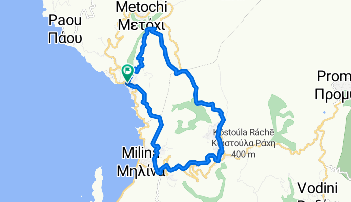
Itinéraire à vélo à Argalastí, Thessaly, Greece
Road ascent followed by a fireroad trail finishing with a fast and flowy descent.
Turn left out of the hotel and climb up the road towads Argalasti
At the first junction turn right to metochi
Once through Metochi look out for a mirror on a pole and take a right down a concrete driveway next to it which then hairpins left.
Follow this path then turn right at the t junction.
Follow this along and down some hairpins then back up the hill
You will see a yellow marker pointing up a very steep climb, dont go up here but take the next left.
Follow this path which has a rather overgrown section, but just plough through as it doesnt last long.
You will come across a steep climb that veers left and about 20 metres after the left hand corner there is a path to the right marked with yellow markers.
Stick to this path all the way to Milina
Take the road back to the hotel.
- 14,4 km
- Distance
- 322 m
- Montée
- 324 m
- Descente
Découvrez plus d'itinéraires
- Lafkos Cycling Round Trip
- Distance
- 20 km
- Montée
- 402 m
- Descente
- 404 m
- Emplacement
- Argalastí, Thessaly, Greece
- Road Circuit
- Distance
- 20,1 km
- Montée
- 418 m
- Descente
- 415 m
- Emplacement
- Argalastí, Thessaly, Greece
- Techy
- Distance
- 13,6 km
- Montée
- 493 m
- Descente
- 493 m
- Emplacement
- Argalastí, Thessaly, Greece
- 160821_Platanias_Argalasti_Platanias
- Distance
- 51,9 km
- Montée
- 1 010 m
- Descente
- 1 008 m
- Emplacement
- Argalastí, Thessaly, Greece
- 160827_Platanias_Katigiorgis_Platanias
- Distance
- 31,9 km
- Montée
- 703 m
- Descente
- 703 m
- Emplacement
- Argalastí, Thessaly, Greece
- 160825_Platanias_Chania_Platanias_3.250hm
- Distance
- 143,3 km
- Montée
- 2 288 m
- Descente
- 2 287 m
- Emplacement
- Argalastí, Thessaly, Greece
- 160823_Platanias_Milies_Platanias
- Distance
- 99,9 km
- Montée
- 1 481 m
- Descente
- 1 483 m
- Emplacement
- Argalastí, Thessaly, Greece
- 160829_Platanias_Siki_Platanias
- Distance
- 73,9 km
- Montée
- 1 195 m
- Descente
- 1 193 m
- Emplacement
- Argalastí, Thessaly, Greece