
Schwaderloch à vélo
Découvre une carte de 59 itinéraires et pistes cyclables près de Schwaderloch, créés par notre communauté.
Portrait de région
Fais connaissance avec Schwaderloch
Trouve l’itinéraire à vélo qui te convient à Schwaderloch, où nous avons 59 pistes cyclables à explorer.
2 546 km
Distance enregistrée
59
Itinéraires cyclables
726
Population
Communauté
Utilisateurs les plus actifs à Schwaderloch


De notre communauté
Les meilleurs itinéraires à vélo dans et autour de Schwaderloch


Route nach Mettauerberg 3287.1, Mettau
Itinéraire à vélo à Schwaderloch, Canton d’Argovie, Suisse
- 3,3 km
- Distance
- 129 m
- Montée
- 64 m
- Descente

Albtal komplett (Albbr. - St.Blasien)
Itinéraire à vélo à Schwaderloch, Canton d’Argovie, Suisse
- 24,7 km
- Distance
- 570 m
- Montée
- 144 m
- Descente

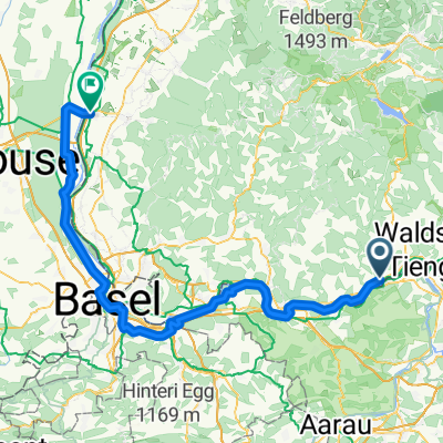
Albert - Rheinfall Fußbrücke 66km
Itinéraire à vélo à Schwaderloch, Canton d’Argovie, Suisse
- 65,6 km
- Distance
- 660 m
- Montée
- 576 m
- Descente

Lange Ausfahrt durch Albbruck
Itinéraire à vélo à Schwaderloch, Canton d’Argovie, Suisse
- 31,8 km
- Distance
- 104 m
- Montée
- 103 m
- Descente
Découvrez plus d'itinéraires
 15_07_16 - Albtal/Wehratal + Dinkelberg
- Distance
- 93,1 km
- Montée
- 981 m
- Descente
- 1 029 m
- Emplacement
- Schwaderloch, Canton d’Argovie, Suisse
 Hauptstrasse 71, Schwaderloch nach Hauptstrasse 7 16, Laufenburg
- Distance
- 8,9 km
- Montée
- 135 m
- Descente
- 130 m
- Emplacement
- Schwaderloch, Canton d’Argovie, Suisse
 Von Süd nach Nord - Etappe 2
- Distance
- 105,7 km
- Montée
- 61 m
- Descente
- 163 m
- Emplacement
- Schwaderloch, Canton d’Argovie, Suisse
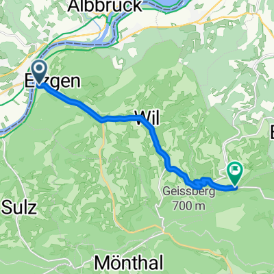
 4-Albbruck-Koblenz
- Distance
- 10,4 km
- Montée
- 35 m
- Descente
- 24 m
- Emplacement
- Schwaderloch, Canton d’Argovie, Suisse
 De Landstrasse 1362, Mettauertal à Kaltenbacherstrasse 4, Stein am Rhein
- Distance
- 76,9 km
- Montée
- 642 m
- Descente
- 532 m
- Emplacement
- Schwaderloch, Canton d’Argovie, Suisse
 messfahrt PW
- Distance
- 8,7 km
- Montée
- 314 m
- Descente
- 21 m
- Emplacement
- Schwaderloch, Canton d’Argovie, Suisse
 Hauptstrasse 73, Schwaderloch to Giessenstraße 26, Bad Säckingen
- Distance
- 19,2 km
- Montée
- 95 m
- Descente
- 115 m
- Emplacement
- Schwaderloch, Canton d’Argovie, Suisse
 Albrucht onwards
- Distance
- 52,8 km
- Montée
- 395 m
- Descente
- 345 m
- Emplacement
- Schwaderloch, Canton d’Argovie, Suisse