
Hägendorf à vélo
Découvre une carte de 100 itinéraires et pistes cyclables près de Hägendorf, créés par notre communauté.
Portrait de région
Fais connaissance avec Hägendorf
Trouve l’itinéraire à vélo qui te convient à Hägendorf, où nous avons 100 pistes cyclables à explorer. La plupart des gens enfourchent leur vélo pour rouler ici aux mois de avril et juin.
5 349 km
Distance enregistrée
100
Itinéraires cyclables
4 338
Population
Communauté
Utilisateurs les plus actifs à Hägendorf


De notre communauté
Les meilleurs itinéraires à vélo dans et autour de Hägendorf


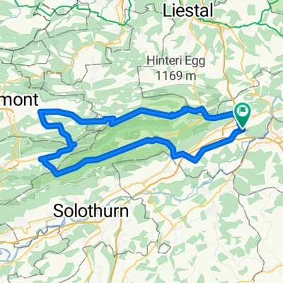
Nellenacker 45, Hägendorf nach Bühlweg 1, Hägendorf
Itinéraire à vélo à Hägendorf, Canton de Soleure, Suisse
- 30,6 km
- Distance
- 217 m
- Montée
- 201 m
- Descente

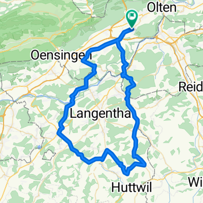
Letzte Etappe Bodensee Rundfahrt
Itinéraire à vélo à Hägendorf, Canton de Soleure, Suisse
- 45,6 km
- Distance
- 185 m
- Montée
- 110 m
- Descente

Moderate Route in Hägendorf
Itinéraire à vélo à Hägendorf, Canton de Soleure, Suisse
- 39,7 km
- Distance
- 133 m
- Montée
- 134 m
- Descente

BaselbietOst mit Passwang
Itinéraire à vélo à Hägendorf, Canton de Soleure, Suisse
- 99,2 km
- Distance
- 1 808 m
- Montée
- 1 808 m
- Descente
Découvrez plus d'itinéraires
 Juraderby im Uhrzeigersinn
- Distance
- 94 km
- Montée
- 1 295 m
- Descente
- 1 295 m
- Emplacement
- Hägendorf, Canton de Soleure, Suisse
 Test Route E-Bike
- Distance
- 50,3 km
- Montée
- 930 m
- Descente
- 875 m
- Emplacement
- Hägendorf, Canton de Soleure, Suisse
 3. Etappe: Kappel - Barbareche
- Distance
- 102,1 km
- Montée
- 548 m
- Descente
- 349 m
- Emplacement
- Hägendorf, Canton de Soleure, Suisse
 Hägendorf Staffelegg Scherz Hägendorf
- Distance
- 91 km
- Montée
- 864 m
- Descente
- 864 m
- Emplacement
- Hägendorf, Canton de Soleure, Suisse
 Schwarzwald Anfahrt II
- Distance
- 63,8 km
- Montée
- 314 m
- Descente
- 401 m
- Emplacement
- Hägendorf, Canton de Soleure, Suisse
 Kappel - Grenchenberg
- Distance
- 115,1 km
- Montée
- 1 568 m
- Descente
- 1 568 m
- Emplacement
- Hägendorf, Canton de Soleure, Suisse
 Kappel, H.buchsee Madiswil, kl.Gotthard 70 km
- Distance
- 70,2 km
- Montée
- 626 m
- Descente
- 624 m
- Emplacement
- Hägendorf, Canton de Soleure, Suisse
 Oberaargau
- Distance
- 106,7 km
- Montée
- 997 m
- Descente
- 997 m
- Emplacement
- Hägendorf, Canton de Soleure, Suisse