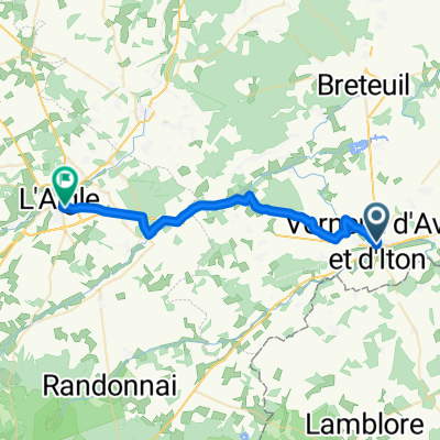
À quoi pourrait ressembler le cyclisme à Verneuil-sur-Avre.

Verneuil-sur-Avre à vélo

Découvre une carte de 30 itinéraires et pistes cyclables près de Verneuil-sur-Avre, créés par notre communauté.

Portrait de région

Fais connaissance avec Verneuil-sur-Avre

Trouve l’itinéraire à vélo qui te convient à Verneuil-sur-Avre, où nous avons 30 pistes cyclables à explorer.

1 405 km

Distance enregistrée

30

Itinéraires cyclables

7 229

Population

Communauté

Utilisateurs les plus actifs à Verneuil-sur-Avre

De notre communauté

Les meilleurs itinéraires à vélo dans et autour de Verneuil-sur-Avre

2009 Euro Tour -- Ride Day 20 — 15 July 2009 — 27130 Verneuil-sur-Avre to 14100 Lisieux CLONED FROM ROUTE 1682062
Vélo de routeRevêtu
Jeff Kadet
0

2009 Euro Tour -- Ride Day 20 — 15 July 2009 — 27130 Verneuil-sur-Avre to 14100 Lisieux CLONED FROM ROUTE 1682062

Itinéraire à vélo à Verneuil-sur-Avre, Normandie, France

<div class="MsoNormal" style="color: #000000; font-family: Helvetica; font-size: medium;"><span style="font-family: Arial;"> <div class="MsoNormal"> <div class="MsoNormal"><span style="font-family: Arial;">Nice ride today although we did have some strong headwinds.<span> </span>Happily in the latter half of the ride, we had some variety of terrain and excellent roads.</span></div> <div class="MsoNormal"><span style="font-family: Arial;"> </span></div> <div class="MsoNormal"><span style="font-family: Arial;">D137 had a terrible climb that warranted at least two arrows rather than the one arrow shown on the map.<span> </span>Right after the climb as we pedaled along D613 toward the Etap, it started to rain just as it had the previous day right before reaching our destination.</span></div> </div> <div class="MsoNormal"><br /></div> </span><span style="font-family: Arial;">During the day, we passed for a couple of short periods from Eure Department in the Haute-Normandie Region into the Orne Department in the Basse-Normandie Region.  Eventually, we exited the Eure Department and passed into the Calvados Department, which is in the Basse-Normandie Region.</span><span style="font-family: Arial;"> <div class="MsoNormal"><span style="font-family: Arial;"> </span></div> </span></div> <div class="MsoNormal" style="color: #000000; font-family: Helvetica; font-size: medium;"><span style="font-family: Arial;"> <div class="MsoNormal"> <div class="MsoNormal"> <div class="MsoNormal"></div> </div> </div> <div class="MsoNormal"><br /></div> </span></div> <div class="MsoNormal" style="color: #000000; font-family: Helvetica; font-size: medium;">Background:<span style="font-family: Arial;"> <div class="MsoNormal" style="font-size: 16px;"><span style="font-family: Arial;"> </span></div> </span></div> My wife and I have been doing self-supported tours in Western Europe (a majority in France) since 1993.  This series of rides covers our 2009 4.5 month route through parts of France, Germany, Austria, Switzerland, and then back to France.  Our beginning and ending point is near Chadurie (south of Angouleme) where our friends have a farm with Gites and Chambres d'Hotes. We rode our Dawes touring bicycles purchased in 1993 heavily loaded with 700Cx32 tires.  All of our riding was on paved roads, mostly with very little traffic.  Pretty much the only unpaved sections were some bicycle paths in Germany and Austria. Sadly, that wasn't so great as Helen fell a number of times on the unpaved paths.  Fortunately, though, no serious injury. If any questions, feel free to email me at jeffkadet@netdiving.com Jeff
80,4 km
Distance
250 m
Montée
281 m
Descente
Verneuil - Saint Sylvestre de Cormeilles
VTTRevêtu
0

Verneuil - Saint Sylvestre de Cormeilles

Itinéraire à vélo à Verneuil-sur-Avre, Normandie, France

Verneuil - Saint Sylvestre de Cormeilles
93,5 km
Distance
168 m
Montée
203 m
Descente
1

V2 Verneuil-s-Arve / Paris 140km

Itinéraire à vélo à Verneuil-sur-Avre, Normandie, France

140,7 km
Distance
361 m
Montée
475 m
Descente
Verneuil-Irai
Non revêtu
0

Verneuil-Irai

Itinéraire à vélo à Verneuil-sur-Avre, Normandie, France

24,9 km
Distance
101 m
Montée
43 m
Descente

Découvrez plus d'itinéraires