
Tignes à vélo
Découvre une carte de 91 itinéraires et pistes cyclables près de Tignes, créés par notre communauté.
Portrait de région
Fais connaissance avec Tignes
Trouve l’itinéraire à vélo qui te convient à Tignes, où nous avons 91 pistes cyclables à explorer. La plupart des gens enfourchent leur vélo pour rouler ici au mois de juillet.
7 484 km
Distance enregistrée
91
Itinéraires cyclables
2 385
Population
Communauté
Utilisateurs les plus actifs à Tignes


De notre communauté
Les meilleurs itinéraires à vélo dans et autour de Tignes
Col de l'Iseran and Mont Cenis
Itinéraire à vélo à Tignes, Auvergne-Rhône-Alpes, France
- 72 km
- Distance
- 1 711 m
- Montée
- 1 739 m
- Descente

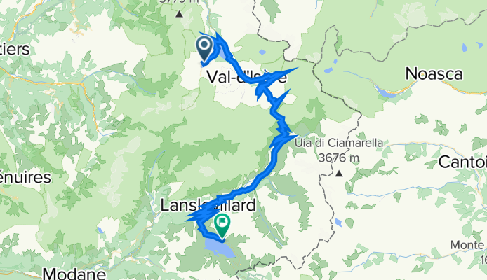
Guillestre - Tignes
Itinéraire à vélo à Tignes, Auvergne-Rhône-Alpes, France
- 231,2 km
- Distance
- 4 232 m
- Montée
- 5 325 m
- Descente

3.Route des Grandes Alpes - Day Three
Itinéraire à vélo à Tignes, Auvergne-Rhône-Alpes, France
<span style="margin: 0px; padding: 0px; border: 0px; outline: 0px; font-size: medium; vertical-align: baseline; background-color: transparent; color: rgb(0, 0, 0); font-family: Tahoma, Geneva, Kalimati, sans-serif; background-position: initial initial; background-repeat: initial initial;">105km 1950m gain, 2 cat. 1 cols</span>
<span style="margin: 0px; padding: 0px; border: 0px; outline: 0px; font-size: small; vertical-align: baseline; background-color: transparent; color: rgb(0, 0, 0); font-family: Tahoma, Geneva, Kalimati, sans-serif; background-position: initial initial; background-repeat: initial initial;">From Val d’Isere it is straight up to the Iseran, an exposed and tough start to the morning but well worth it for the view from the top. The descent seems endless at 73km but well deserved and very beautiful, it brings us down to St Michel-de-Maurienne where with rested legs we tackle the Col du Telegraphe which at 830m height gain is a tough but good end to the day as it winds up through the trees which offer good shade on a hot day. A short descent takes us to Valloire and the hotel.</span>
<span style="margin: 0px; padding: 0px; border: 0px; outline: 0px; font-size: small; vertical-align: baseline; background-color: transparent; color: rgb(0, 0, 0); font-family: Tahoma, Geneva, Kalimati, sans-serif; background-position: initial initial; background-repeat: initial initial;">Accommodation: </span><span style="color: rgb(34, 34, 34); font-family: Arial, Verdana, sans-serif;">Hôtel Patchwork, </span><span style="color: rgb(34, 34, 34); font-family: Arial, Verdana, sans-serif;">Route des Grandes Alpes, </span><span style="color: rgb(34, 34, 34); font-family: Arial, Verdana, sans-serif;">73450 Valloire, </span><span style="color: rgb(34, 34, 34); font-family: Arial, Verdana, sans-serif;">04.79.59.00.99</span>
- 109,8 km
- Distance
- 1 851 m
- Montée
- 2 250 m
- Descente

to furnicular
Itinéraire à vélo à Tignes, Auvergne-Rhône-Alpes, France
- 0,6 km
- Distance
- 12 m
- Montée
- 32 m
- Descente
Découvrez plus d'itinéraires
 Tignes Cormet De Roselend Val Thorens 151km
- Distance
- 151,4 km
- Montée
- 3 147 m
- Descente
- 2 928 m
- Emplacement
- Tignes, Auvergne-Rhône-Alpes, France
 TDLA etp 5B Tignes - colle di somelier
- Distance
- 148,9 km
- Montée
- 3 989 m
- Descente
- 3 109 m
- Emplacement
- Tignes, Auvergne-Rhône-Alpes, France
 Tignes-Val Thorens-Cormet d´Acheres-Col du Pre-Cormet de Roseland-Tignes
- Distance
- 231,2 km
- Montée
- 5 026 m
- Descente
- 5 059 m
- Emplacement
- Tignes, Auvergne-Rhône-Alpes, France
 Tour de France 2019 3. Etappe
- Distance
- 216,3 km
- Montée
- 1 040 m
- Descente
- 2 435 m
- Emplacement
- Tignes, Auvergne-Rhône-Alpes, France
 TIGNES - COL DE L'ISERAN
- Distance
- 28,6 km
- Montée
- 1 267 m
- Descente
- 595 m
- Emplacement
- Tignes, Auvergne-Rhône-Alpes, France
 Tignes - Col D´Iseran
- Distance
- 30,6 km
- Montée
- 1 209 m
- Descente
- 583 m
- Emplacement
- Tignes, Auvergne-Rhône-Alpes, France
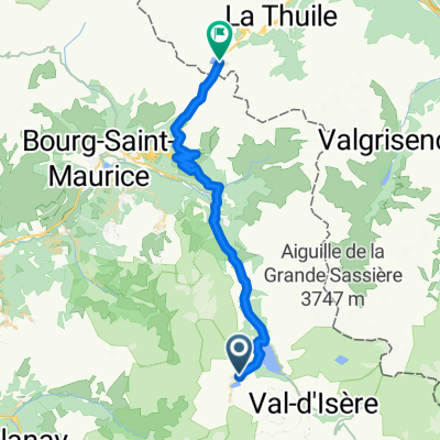 Tignes - Col de Petit st. Bernard
- Distance
- 39,8 km
- Montée
- 1 121 m
- Descente
- 1 057 m
- Emplacement
- Tignes, Auvergne-Rhône-Alpes, France
 Tignes to D902, Val-d'Isère
- Distance
- 29,4 km
- Montée
- 1 007 m
- Descente
- 330 m
- Emplacement
- Tignes, Auvergne-Rhône-Alpes, France