
Parsons à vélo
Découvre une carte de 26 itinéraires et pistes cyclables près de Parsons, créés par notre communauté.
Portrait de région
Fais connaissance avec Parsons
Trouve l’itinéraire à vélo qui te convient à Parsons, où nous avons 26 pistes cyclables à explorer.
1 358 km
Distance enregistrée
26
Itinéraires cyclables
1 485
Population
Communauté
Utilisateurs les plus actifs à Parsons


De notre communauté
Les meilleurs itinéraires à vélo dans et autour de Parsons
Allegheny Highlands Trail of Wv, Parsons to Main St, Parsons
Itinéraire à vélo à Parsons, Virginie-Occidentale, États Unis
- 42,2 km
- Distance
- 531 m
- Montée
- 527 m
- Descente

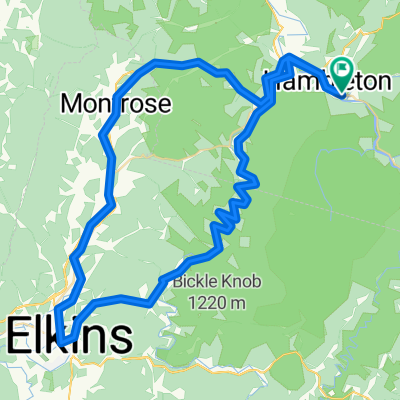
Limestone Mt. Loop
Itinéraire à vélo à Parsons, Virginie-Occidentale, États Unis
- 33,4 km
- Distance
- 587 m
- Montée
- 587 m
- Descente

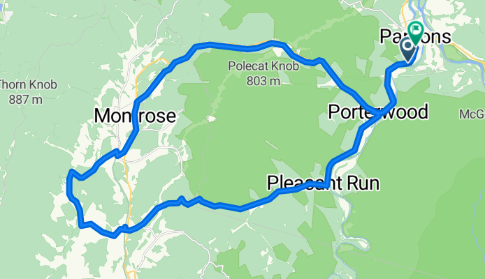
Parsons-Montrose Loop
Itinéraire à vélo à Parsons, Virginie-Occidentale, États Unis
- 61,5 km
- Distance
- 604 m
- Montée
- 602 m
- Descente

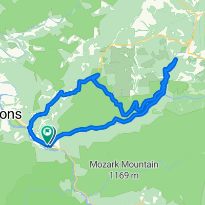
Horseshoe - Limestone Mt. Ride
Itinéraire à vélo à Parsons, Virginie-Occidentale, États Unis
- 55 km
- Distance
- 677 m
- Montée
- 677 m
- Descente
Découvrez plus d'itinéraires
 Texas Mountain
- Distance
- 34,7 km
- Montée
- 502 m
- Descente
- 502 m
- Emplacement
- Parsons, Virginie-Occidentale, États Unis
 Pifer Mountain Loop
- Distance
- 31,4 km
- Montée
- 557 m
- Descente
- 557 m
- Emplacement
- Parsons, Virginie-Occidentale, États Unis
 Backbone Mountain Climb
- Distance
- 8,7 km
- Montée
- 534 m
- Descente
- 26 m
- Emplacement
- Parsons, Virginie-Occidentale, États Unis
 Olson Fire Tower to Parsons
- Distance
- 35,8 km
- Montée
- 96 m
- Descente
- 710 m
- Emplacement
- Parsons, Virginie-Occidentale, États Unis
 BW falls to Parsons to Deck Creek to apt
- Distance
- 124,3 km
- Montée
- 959 m
- Descente
- 1 571 m
- Emplacement
- Parsons, Virginie-Occidentale, États Unis
 Route in Hendricks
- Distance
- 83,8 km
- Montée
- 1 531 m
- Descente
- 1 531 m
- Emplacement
- Parsons, Virginie-Occidentale, États Unis
 Bfalls to Moundsville
- Distance
- 201,5 km
- Montée
- 1 391 m
- Descente
- 2 151 m
- Emplacement
- Parsons, Virginie-Occidentale, États Unis
 Second St, Hendricks to Allegheny Highlands Trail of Wv, Hendricks
- Distance
- 39,5 km
- Montée
- 798 m
- Descente
- 794 m
- Emplacement
- Parsons, Virginie-Occidentale, États Unis