
Maplewood à vélo
Découvre une carte de 62 itinéraires et pistes cyclables près de Maplewood, créés par notre communauté.
Portrait de région
Fais connaissance avec Maplewood
Trouve l’itinéraire à vélo qui te convient à Maplewood, où nous avons 62 pistes cyclables à explorer. La plupart des gens enfourchent leur vélo pour rouler ici aux mois de juillet et août.
1 098 km
Distance enregistrée
62
Itinéraires cyclables
38 018
Population

De notre communauté
Les meilleurs itinéraires à vélo dans et autour de Maplewood

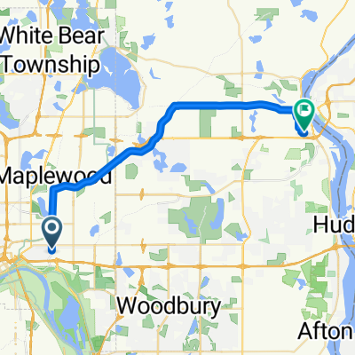
B2B00211 55119>55101 via Upper Afton, 7th Street
Itinéraire à vélo à Maplewood, Minnesota, États Unis
- 17,8 km
- Distance
- 189 m
- Montée
- 192 m
- Descente

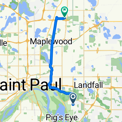
Mississippi River Trail: Maplewood to Columbia Heights
Itinéraire à vélo à Maplewood, Minnesota, États Unis
- 35,3 km
- Distance
- 256 m
- Montée
- 222 m
- Descente

Maplewood Cycling
Itinéraire à vélo à Maplewood, Minnesota, États Unis
- 14,1 km
- Distance
- 450 m
- Montée
- 299 m
- Descente

Handsome Cycles
Itinéraire à vélo à Maplewood, Minnesota, États Unis
- 38,6 km
- Distance
- 280 m
- Montée
- 300 m
- Descente
Découvrez plus d'itinéraires
 B2B00784 55125>55164 via Up.Afton/Ruth/Mhaha/JohnsonPkwy/Wheelock/Edgerton/VadLake/Rice/Gramsie/Lex
- Distance
- 27,1 km
- Montée
- 127 m
- Descente
- 137 m
- Emplacement
- Maplewood, Minnesota, États Unis
 B2B00182 55106 > 55101 vie Johnson Pkwy., Hudson, Kellogg
- Distance
- 6,5 km
- Montée
- 46 m
- Descente
- 80 m
- Emplacement
- Maplewood, Minnesota, États Unis
 B2B00497 55106>55082 via Bruce Vento Trl, Gateway Trl, Myrtle Av
- Distance
- 28,4 km
- Montée
- 92 m
- Descente
- 89 m
- Emplacement
- Maplewood, Minnesota, États Unis
 B2B00956 55119>55401 via Case Av, Como Av, 4th St SE
- Distance
- 24 km
- Montée
- 159 m
- Descente
- 192 m
- Emplacement
- Maplewood, Minnesota, États Unis
 B2B00758 55119>55128 viaUpperAfton/Century/HudsonRd./Hadley Hudson
- Distance
- 13,8 km
- Montée
- 91 m
- Descente
- 78 m
- Emplacement
- Maplewood, Minnesota, États Unis
 B2B00576 55119>55110 via Upper Afton Rd, Johnson Pkwy, Bruce Vento Trl
- Distance
- 17,1 km
- Montée
- 74 m
- Descente
- 100 m
- Emplacement
- Maplewood, Minnesota, États Unis
 B2B00401 55106>55454 via WheelockPkwy/Como/IntercampusTrail/27SE/Franklin/Riverside
- Distance
- 19,1 km
- Montée
- 69 m
- Descente
- 71 m
- Emplacement
- Maplewood, Minnesota, États Unis
 WB CTY PARK
- Distance
- 17,3 km
- Montée
- 59 m
- Descente
- 71 m
- Emplacement
- Maplewood, Minnesota, États Unis