
Saint Paul à vélo
Découvre une carte de 491 itinéraires et pistes cyclables près de Saint Paul, créés par notre communauté.
Portrait de région
Fais connaissance avec Saint Paul
Trouve l’itinéraire à vélo qui te convient à Saint Paul, où nous avons 491 pistes cyclables à explorer. La plupart des gens enfourchent leur vélo pour rouler ici aux mois de juin et août.
20 564 km
Distance enregistrée
491
Itinéraires cyclables
285 068
Population
Communauté
Utilisateurs les plus actifs à Saint Paul


De notre communauté
Les meilleurs itinéraires à vélo dans et autour de Saint Paul

River Ramble 20
Itinéraire à vélo à Saint Paul, Minnesota, États Unis
- 29,6 km
- Distance
- 196 m
- Montée
- 197 m
- Descente

B2B00368 55102 > 55417 via Shepard Rd, Godfrey, Minnehaha, River Pkwy
Itinéraire à vélo à Saint Paul, Minnesota, États Unis
- 17,8 km
- Distance
- 96 m
- Montée
- 119 m
- Descente

B2B00192 55102>55404viaShepherdRd/MissBlvd/WRiverPkwy/MidtwnGrnway
Itinéraire à vélo à Saint Paul, Minnesota, États Unis
- 21,8 km
- Distance
- 131 m
- Montée
- 86 m
- Descente

B2B00418 55117>55123 via Cedar, Wabasha, Lexington, Pilot Knob Rd
Itinéraire à vélo à Saint Paul, Minnesota, États Unis
- 20,8 km
- Distance
- 161 m
- Montée
- 156 m
- Descente
Découvrez plus d'itinéraires
 B2B00062 55106 - 55075 via Concord, NURT
- Distance
- 9,5 km
- Montée
- 80 m
- Descente
- 110 m
- Emplacement
- Saint Paul, Minnesota, États Unis
 St Paul Gateway to: Brown’s creek to Stillwater and back .
- Distance
- 64,2 km
- Montée
- 408 m
- Descente
- 409 m
- Emplacement
- Saint Paul, Minnesota, États Unis
 Gateway State Trail
- Distance
- 30 km
- Montée
- 115 m
- Descente
- 69 m
- Emplacement
- Saint Paul, Minnesota, États Unis
 To the River Center
- Distance
- 17,1 km
- Montée
- 117 m
- Descente
- 90 m
- Emplacement
- Saint Paul, Minnesota, États Unis
 B2B00024 55104 > 55121 via Big Rivers Trail
- Distance
- 16,8 km
- Montée
- 174 m
- Descente
- 174 m
- Emplacement
- Saint Paul, Minnesota, États Unis
 Jackson Street to East 7th Street
- Distance
- 1,6 km
- Montée
- 36 m
- Descente
- 0 m
- Emplacement
- Saint Paul, Minnesota, États Unis
 Way to Church
- Distance
- 13,2 km
- Montée
- 54 m
- Descente
- 37 m
- Emplacement
- Saint Paul, Minnesota, États Unis
 B2B00629 55102 < 55402 via Summit, River Road, West bank, Downtown
- Distance
- 15,5 km
- Montée
- 82 m
- Descente
- 94 m
- Emplacement
- Saint Paul, Minnesota, États Unis
Itinéraires vers Saint Paul
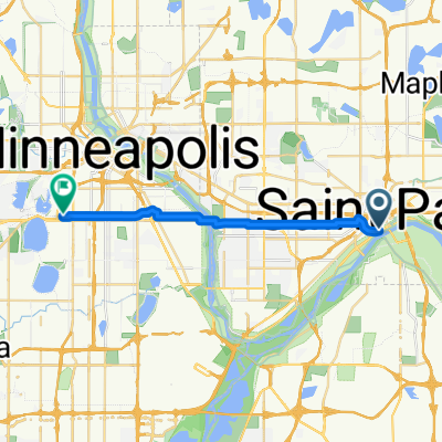
Excursion à vélo d’une journée de
Minneapolis à Saint Paul
Sortie rapide à vélo de
Falcon Heights à Saint Paul