
South San Gabriel à vélo
Découvre une carte de 17 itinéraires et pistes cyclables près de South San Gabriel, créés par notre communauté.
Portrait de région
Fais connaissance avec South San Gabriel
Trouve l’itinéraire à vélo qui te convient à South San Gabriel, où nous avons 17 pistes cyclables à explorer.
321 km
Distance enregistrée
17
Itinéraires cyclables
8 070
Population
Communauté
Utilisateurs les plus actifs à South San Gabriel


De notre communauté
Les meilleurs itinéraires à vélo dans et autour de South San Gabriel

#GOONSQUAD GAUNTLET
Itinéraire à vélo à South San Gabriel, Californie, États Unis
- 25,3 km
- Distance
- 209 m
- Montée
- 182 m
- Descente

Triathlon bike distance with 2 stops
Itinéraire à vélo à South San Gabriel, Californie, États Unis
- 70,1 km
- Distance
- 727 m
- Montée
- 718 m
- Descente

Moderate route in San Gabriel
Itinéraire à vélo à South San Gabriel, Californie, États Unis
- 12,6 km
- Distance
- 75 m
- Montée
- 45 m
- Descente

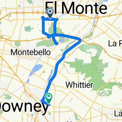
Upper Rio Hondo, Rosemead to 1701 Santa Anita Ave, South El Monte
Itinéraire à vélo à South San Gabriel, Californie, États Unis
- 10,2 km
- Distance
- 89 m
- Montée
- 82 m
- Descente
Découvrez plus d'itinéraires
 8682 Garvey Ave, Rosemead to 11782–11784 Telegraph Rd, Santa Fe Springs
- Distance
- 35 km
- Montée
- 101 m
- Descente
- 135 m
- Emplacement
- South San Gabriel, Californie, États Unis
 2727 Pellissier Pl City Of Industry, CA 90601 美国
- Distance
- 0,3 km
- Montée
- 16 m
- Descente
- 0 m
- Emplacement
- South San Gabriel, Californie, États Unis
 Route #1
- Distance
- 17,8 km
- Montée
- 224 m
- Descente
- 95 m
- Emplacement
- South San Gabriel, Californie, États Unis
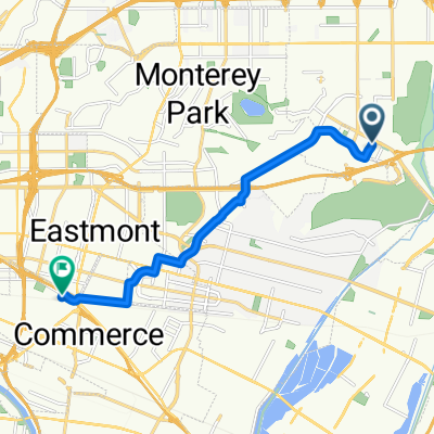 1151 San Gabriel Blvd, Rosemead to 5116 Triggs St, Commerce
- Distance
- 9,8 km
- Montée
- 75 m
- Descente
- 126 m
- Emplacement
- South San Gabriel, Californie, États Unis
 Recovered Route
- Distance
- 6,2 km
- Montée
- 42 m
- Descente
- 58 m
- Emplacement
- South San Gabriel, Californie, États Unis
 Steady ride in Alhambra
- Distance
- 9,5 km
- Montée
- 115 m
- Descente
- 32 m
- Emplacement
- South San Gabriel, Californie, États Unis
 pub crawl Rosemead /SGV
- Distance
- 16,4 km
- Montée
- 63 m
- Descente
- 22 m
- Emplacement
- South San Gabriel, Californie, États Unis
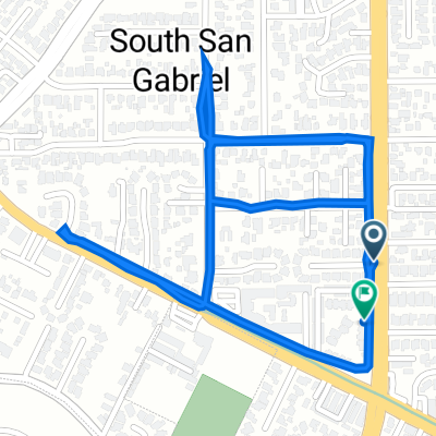 8135 Wagon Wheel Ct, Rosemead to 1445 San Gabriel Blvd, Rosemead
- Distance
- 3 km
- Montée
- 23 m
- Descente
- 25 m
- Emplacement
- South San Gabriel, Californie, États Unis