
Mukilteo à vélo
Découvre une carte de 93 itinéraires et pistes cyclables près de Mukilteo, créés par notre communauté.
Portrait de région
Fais connaissance avec Mukilteo
Trouve l’itinéraire à vélo qui te convient à Mukilteo, où nous avons 93 pistes cyclables à explorer. La plupart des gens enfourchent leur vélo pour rouler ici aux mois de juin et juillet.
3 274 km
Distance enregistrée
93
Itinéraires cyclables
20 254
Population
Communauté
Utilisateurs les plus actifs à Mukilteo


De notre communauté
Les meilleurs itinéraires à vélo dans et autour de Mukilteo
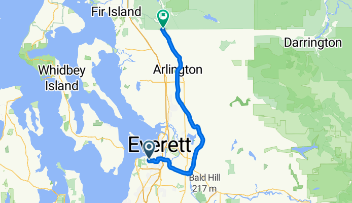
Everett to Skagit County Line via Centennial Trail
Itinéraire à vélo à Mukilteo, Washington, United States of America
Also utilizes a portion of the Interurban Trail in Everett. New connector between 204th and Downtown Arlington scheduled for completion 2013. Beware Centennial Trail congestion on weekends with nice weather. Only big hill is from Everett to Snohomish River Valley.
- 64,8 km
- Distance
- 248 m
- Montée
- 294 m
- Descente

Everett to LaConner
Itinéraire à vélo à Mukilteo, Washington, United States of America
Good trip if you don't mind a bit of traffic here and there. A real mixed bag as far as shoulders / no shoulders, also. Have some Fudge in LaConner and forget all that. Stop at the Snow Goose Produce stand on Fir Island Rd. for fresh fruits and veggies, fire-baked pizza and ice cream cones too! Dodge Valley Rd. is chip-seal :( all others are fine.
- 81,2 km
- Distance
- 200 m
- Montée
- 318 m
- Descente

Everett-Maple Valley 4 Trails
Itinéraire à vélo à Mukilteo, Washington, United States of America
Combines three bike trails: Interurban, Burke-Gilman, Cedar River and Sammamish River. There is a two mile stretch of gravel trail N. of Issaquah but it is packed and tolerable for this short stretch. Suggest using King County Bicycle Map for portion S. of UW or else follow the "Lk. Washington Loop" green signs.
- 174,4 km
- Distance
- 458 m
- Montée
- 458 m
- Descente

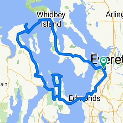
Everett-LaConner-Whidbey Loop
Itinéraire à vélo à Mukilteo, Washington, United States of America
The portion between Everett and LaConner is very flat, the rest is moderate hills. One could choose a more scenic backroad route thru Whidbey Island but it would add more miles and bigger hills. Don't miss the candy shop in LaConner. Get a good meal at the cafe in Silvana.
- 195,7 km
- Distance
- 727 m
- Montée
- 726 m
- Descente
Découvrez plus d'itinéraires
 Paine Field Area Hill Ride
- Distance
- 24,3 km
- Montée
- 352 m
- Descente
- 349 m
- Emplacement
- Mukilteo, Washington, United States of America
 EI to Marymoor
- Distance
- 40 km
- Montée
- 115 m
- Descente
- 272 m
- Emplacement
- Mukilteo, Washington, United States of America
 4 Lighthouse Century
- Distance
- 198,8 km
- Montée
- 945 m
- Descente
- 945 m
- Emplacement
- Mukilteo, Washington, United States of America
 Everett to Lk Washington Loop
- Distance
- 132,8 km
- Montée
- 643 m
- Descente
- 643 m
- Emplacement
- Mukilteo, Washington, United States of America
 Paine Field hill route.
- Distance
- 33,7 km
- Montée
- 432 m
- Descente
- 432 m
- Emplacement
- Mukilteo, Washington, United States of America
 Relaxed route in Mukilteo
- Distance
- 5,7 km
- Montée
- 218 m
- Descente
- 215 m
- Emplacement
- Mukilteo, Washington, United States of America
 try this
- Distance
- 38,3 km
- Montée
- 234 m
- Descente
- 284 m
- Emplacement
- Mukilteo, Washington, United States of America
 USA - Mukilteo: Pudget Sound Discovery Tour
- Distance
- 156,8 km
- Montée
- 735 m
- Descente
- 735 m
- Emplacement
- Mukilteo, Washington, United States of America