
Smokey Point à vélo
Découvre une carte de 19 itinéraires et pistes cyclables près de Smokey Point, créés par notre communauté.
Portrait de région
Fais connaissance avec Smokey Point
Trouve l’itinéraire à vélo qui te convient à Smokey Point, où nous avons 19 pistes cyclables à explorer. La plupart des gens enfourchent leur vélo pour rouler ici au mois de mai.
569 km
Distance enregistrée
19
Itinéraires cyclables
1 572
Population
Communauté
Utilisateurs les plus actifs à Smokey Point


De notre communauté
Les meilleurs itinéraires à vélo dans et autour de Smokey Point


Arlington to Seattle
Itinéraire à vélo à Smokey Point, Washington, États Unis
- 97,6 km
- Distance
- 1 514 m
- Montée
- 1 459 m
- Descente

Easy ride in Arlington
Itinéraire à vélo à Smokey Point, Washington, États Unis
- 40,9 km
- Distance
- 196 m
- Montée
- 195 m
- Descente
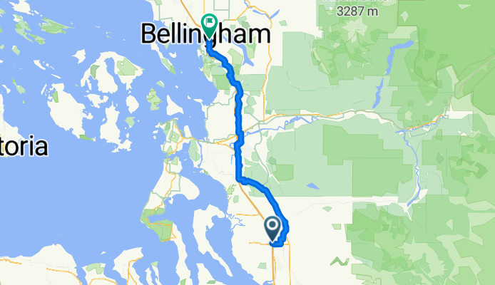
172nd St NE, Arlington to Lakeway Dr, Bellingham
Itinéraire à vélo à Smokey Point, Washington, États Unis
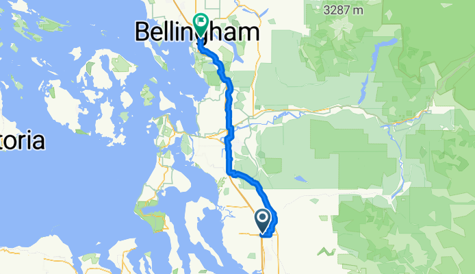
- 93,7 km
- Distance
- 604 m
- Montée
- 593 m
- Descente
Smokey Point Dr, Arlington to Lakeway Dr, Bellingham
Itinéraire à vélo à Smokey Point, Washington, États Unis
- 92,3 km
- Distance
- 964 m
- Montée
- 952 m
- Descente
Découvrez plus d'itinéraires
 15405 67th Ave NE, Arlington to 15405 67th Ave NE, Arlington
- Distance
- 10,9 km
- Montée
- 69 m
- Descente
- 70 m
- Emplacement
- Smokey Point, Washington, États Unis
 15405 67th Ave NE, Arlington to 15405 67th Ave NE, Arlington
- Distance
- 11,1 km
- Montée
- 74 m
- Descente
- 72 m
- Emplacement
- Smokey Point, Washington, États Unis
 18828 Smokey Point Blvd, Arlington to 14714–14798 Summers Dr, Mount Vernon
- Distance
- 42,1 km
- Montée
- 330 m
- Descente
- 348 m
- Emplacement
- Smokey Point, Washington, États Unis
 15291–15359 67th Ave NE, Arlington to 15405 67th Ave NE, Arlington
- Distance
- 5,2 km
- Montée
- 23 m
- Descente
- 23 m
- Emplacement
- Smokey Point, Washington, États Unis
 15405 67th Ave NE, Arlington to 15405 67th Ave NE, Arlington
- Distance
- 11,1 km
- Montée
- 65 m
- Descente
- 66 m
- Emplacement
- Smokey Point, Washington, États Unis
 15405 67th Ave NE, Arlington to 15405 67th Ave NE, Arlington
- Distance
- 13 km
- Montée
- 118 m
- Descente
- 116 m
- Emplacement
- Smokey Point, Washington, États Unis
 15405 67th Ave NE, Arlington to 15405 67th Ave NE, Arlington
- Distance
- 11,1 km
- Montée
- 86 m
- Descente
- 87 m
- Emplacement
- Smokey Point, Washington, États Unis
 hdjdj
hdjdj- Distance
- 29,1 km
- Montée
- 653 m
- Descente
- 634 m
- Emplacement
- Smokey Point, Washington, États Unis