
23 August à vélo
Découvre une carte de 49 itinéraires et pistes cyclables près de 23 August, créés par notre communauté.
Portrait de région
Fais connaissance avec 23 August
Trouve l’itinéraire à vélo qui te convient à 23 August, où nous avons 49 pistes cyclables à explorer. La plupart des gens enfourchent leur vélo pour rouler ici aux mois de juillet et août.
3 310 km
Distance enregistrée
49
Itinéraires cyclables
2 849
Population
Communauté
Utilisateurs les plus actifs à 23 August


De notre communauté
Les meilleurs itinéraires à vélo dans et autour de 23 August


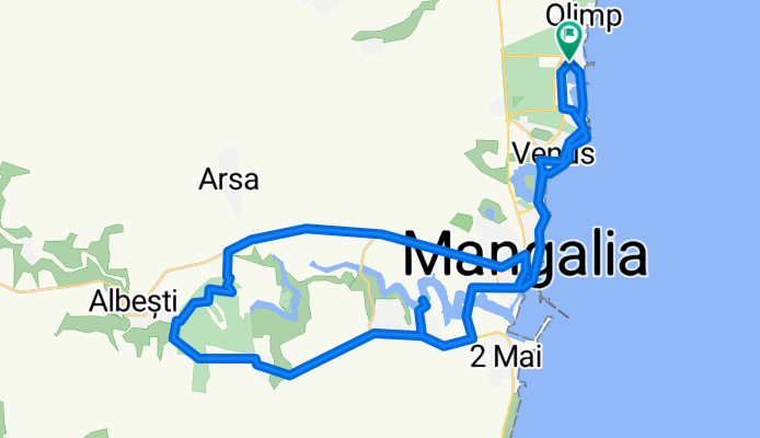
Strada Trandafirilor, Mangalia to Strada Trandafirilor, Mangalia
Itinéraire à vélo à 23 August, Constanța, Roumanie
- 52,5 km
- Distance
- 318 m
- Montée
- 318 m
- Descente

Strada Trandafirilor, Mangalia to Strada Trandafirilor, Mangalia
Itinéraire à vélo à 23 August, Constanța, Roumanie
- 55,3 km
- Distance
- 326 m
- Montée
- 326 m
- Descente


Hotel Amfiteatru-Mangalia-Limanu-Hagieni-Arsa-Pecineaga-23August-Hotel Amfiteatru
Itinéraire à vélo à 23 August, Constanța, Roumanie
- 55,7 km
- Distance
- 344 m
- Montée
- 344 m
- Descente


hotel Amfiteatru Olimp-Mangalia și retur
Itinéraire à vélo à 23 August, Constanța, Roumanie
- 26,6 km
- Distance
- 100 m
- Montée
- 101 m
- Descente
Découvrez plus d'itinéraires
 Camino Litoral Marea Neagră
- Distance
- 44,8 km
- Montée
- 168 m
- Descente
- 170 m
- Emplacement
- 23 August, Constanța, Roumanie
 Olimp - 23 August - Costinesti - Tuzla - Eforie Sud - Eforie Nord
- Distance
- 29,2 km
- Montée
- 132 m
- Descente
- 133 m
- Emplacement
- 23 August, Constanța, Roumanie
 olimp mangalia
- Distance
- 24,8 km
- Montée
- 94 m
- Descente
- 93 m
- Emplacement
- 23 August, Constanța, Roumanie
 Neptun - Mangalia
- Distance
- 23,5 km
- Montée
- 104 m
- Descente
- 107 m
- Emplacement
- 23 August, Constanța, Roumanie
 tura de vacanta 2019 Olimp
- Distance
- 127 km
- Montée
- 288 m
- Descente
- 288 m
- Emplacement
- 23 August, Constanța, Roumanie
 Strada Gării 1, Neptun to Strada Ion Creangă Nr 2, Vama Veche
- Distance
- 18,1 km
- Montée
- 128 m
- Descente
- 136 m
- Emplacement
- 23 August, Constanța, Roumanie
 Sea Aude Ride
- Distance
- 36,4 km
- Montée
- 137 m
- Descente
- 137 m
- Emplacement
- 23 August, Constanța, Roumanie
 DN39 78, 23 August to Strada Mihai Viteazu 18, Mangalia
- Distance
- 15,6 km
- Montée
- 49 m
- Descente
- 87 m
- Emplacement
- 23 August, Constanța, Roumanie