
Bexley North à vélo
Découvre une carte de 56 itinéraires et pistes cyclables près de Bexley North, créés par notre communauté.
Portrait de région
Fais connaissance avec Bexley North
Trouve l’itinéraire à vélo qui te convient à Bexley North, où nous avons 56 pistes cyclables à explorer.
1 673 km
Distance enregistrée
56
Itinéraires cyclables
3 999
Population
Communauté
Utilisateurs les plus actifs à Bexley North


De notre communauté
Les meilleurs itinéraires à vélo dans et autour de Bexley North

cooks River home loop
Itinéraire à vélo à Bexley North, Nouvelle-Galles du Sud, Australie
- 10,2 km
- Distance
- 146 m
- Montée
- 139 m
- Descente
![(Map 3) M5 Linear Park (Kingsgrove) to Bexley [via Bexley North]](https://media.bikemap.net/routes/15929589/staticmaps/in_a8a15940-1200-41d0-a1ed-7ff8b7b97ec0_694x400_bikemap-2021-3D-static.png)
(Map 3) M5 Linear Park (Kingsgrove) to Bexley [via Bexley North]
Itinéraire à vélo à Bexley North, Nouvelle-Galles du Sud, Australie
- 3,6 km
- Distance
- 31 m
- Montée
- 4 m
- Descente

(Map 3D) M5 Linear Park to Bexley Pool
Itinéraire à vélo à Bexley North, Nouvelle-Galles du Sud, Australie
- 2,7 km
- Distance
- 32 m
- Montée
- 16 m
- Descente
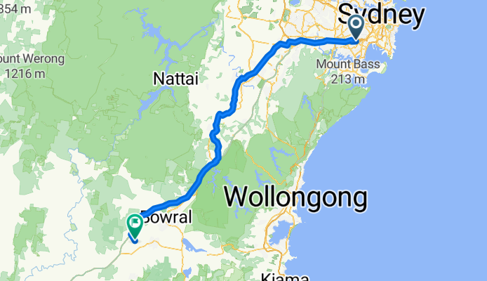
Miller Avenue 16, Bexley North to Golden Vale Road, Sutton Forest
Itinéraire à vélo à Bexley North, Nouvelle-Galles du Sud, Australie
- 132 km
- Distance
- 2 182 m
- Montée
- 1 566 m
- Descente
Découvrez plus d'itinéraires
 Bexley North to Cooks River
- Distance
- 3,7 km
- Montée
- 32 m
- Descente
- 45 m
- Emplacement
- Bexley North, Nouvelle-Galles du Sud, Australie
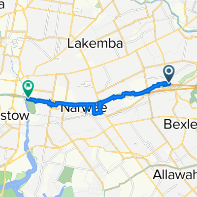
 9 Calbina Road, Earlwood to 13 Calbina Road, Earlwood
- Distance
- 22,6 km
- Montée
- 34 m
- Descente
- 57 m
- Emplacement
- Bexley North, Nouvelle-Galles du Sud, Australie
 Kingsland road to Struthers st
- Distance
- 19 km
- Montée
- 98 m
- Descente
- 129 m
- Emplacement
- Bexley North, Nouvelle-Galles du Sud, Australie
 Bexley North to Salt Pan Creek Reserve (M5 East Tunnel Cycleway)
- Distance
- 8,4 km
- Montée
- 54 m
- Descente
- 67 m
- Emplacement
- Bexley North, Nouvelle-Galles du Sud, Australie
 Bexley Rd, Kingsgrove to 3 The Crescent, Kingsgrove
- Distance
- 4,7 km
- Montée
- 30 m
- Descente
- 18 m
- Emplacement
- Bexley North, Nouvelle-Galles du Sud, Australie
 Clemton Park to Lakemba
- Distance
- 3,4 km
- Montée
- 44 m
- Descente
- 29 m
- Emplacement
- Bexley North, Nouvelle-Galles du Sud, Australie
 Bexley North - Home
- Distance
- 4,9 km
- Montée
- 57 m
- Descente
- 28 m
- Emplacement
- Bexley North, Nouvelle-Galles du Sud, Australie
 63 Shaw Street, Bexley North to 29 Fletcher Street, Campsie
- Distance
- 3,7 km
- Montée
- 42 m
- Descente
- 22 m
- Emplacement
- Bexley North, Nouvelle-Galles du Sud, Australie