
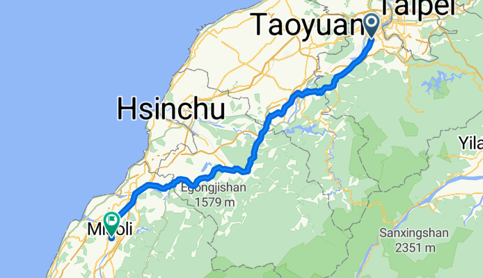
Modèle d’itinéraire
De Banqiao à Miaoli

- 8 h 20 min
- Durée
- 136,3 km
- Distance
- 1 015 m
- Montée
- 974 m
- Descente
- 16,4 km/h
- Vit. moyenne
- 394 m
- Altitude max.
Get ready for an awesome ride! You’ll start off in Banqiao, a bustling district in New Taipei City known for its lively night markets, beautiful parks, and easy connections to downtown Taipei. From there, you’ll make your way southwest for about 136 km all the way to Miaoli, a charming town famous for its Hakka culture, delicious strawberries, and scenic hilly landscapes.
The route is cyclist-friendly, with nearly half the distance on designated cycleways and plenty of quiet roads to soak up Taiwan’s countryside vibe. There’s some climbing involved—about 1,000 meters of ascent—and a maximum elevation just under 400 m, so expect some rolling hills, especially as you get closer to Miaoli. Most of the ride is on paved surfaces, but there are some sections where you might encounter unlisted or mixed terrain, so be prepared for the occasional bumpy patch.
As you roll into Miaoli, treat yourself to Hakka snacks or a local tea, and enjoy the laid-back pace that this part of Taiwan is known for. It’s a satisfying long ride, perfect for adventurous cyclists eager to see Taiwan beyond the city limits!
Communauté
Meilleurs utilisateurs dans cette région


De notre communauté
Les meilleurs itinéraires à vélo de Banqiao à Miaoli


An incidental start of rounding Formosa by parts
Itinéraire à vélo à Banqiao, Taipei, Taïwan
- 116,5 km
- Distance
- 191 m
- Montée
- 193 m
- Descente


1st Day_PlanB
Itinéraire à vélo à Banqiao, Taipei, Taïwan
- 107 km
- Distance
- 375 m
- Montée
- 377 m
- Descente

1st Day
Itinéraire à vélo à Banqiao, Taipei, Taïwan
- 107,8 km
- Distance
- 455 m
- Montée
- 442 m
- Descente


台三線羅馬公路明德水庫
Itinéraire à vélo à Banqiao, Taipei, Taïwan
- 147 km
- Distance
- 3 800 m
- Montée
- 3 739 m
- Descente


20110711_台北縣校長單車隊環島路線第一天
Itinéraire à vélo à Banqiao, Taipei, Taïwan
- 94,4 km
- Distance
- 304 m
- Montée
- 304 m
- Descente
樂活鐵馬-第一天
Itinéraire à vélo à Banqiao, Taipei, Taïwan
- 117 km
- Distance
- 351 m
- Montée
- 356 m
- Descente
Découvrez plus d'itinéraires
 1st Day_PlanB
- Distance
- 107 km
- Montée
- 375 m
- Descente
- 377 m
- Emplacement
- Banqiao, Taipei, Taïwan
 1st Day
- Distance
- 107,8 km
- Montée
- 455 m
- Descente
- 442 m
- Emplacement
- Banqiao, Taipei, Taïwan
 瘋200--001
- Distance
- 126,6 km
- Montée
- 212 m
- Descente
- 201 m
- Emplacement
- Banqiao, Taipei, Taïwan
 台三線羅馬公路明德水庫
- Distance
- 147 km
- Montée
- 3 800 m
- Descente
- 3 739 m
- Emplacement
- Banqiao, Taipei, Taïwan
 土城板橋到濱海
- Distance
- 88,9 km
- Montée
- 234 m
- Descente
- 260 m
- Emplacement
- Banqiao, Taipei, Taïwan
 20110711_台北縣校長單車隊環島路線第一天
- Distance
- 94,4 km
- Montée
- 304 m
- Descente
- 304 m
- Emplacement
- Banqiao, Taipei, Taïwan
 11.新北-苗栗
- Distance
- 102,7 km
- Montée
- 683 m
- Descente
- 653 m
- Emplacement
- Banqiao, Taipei, Taïwan
 樂活鐵馬-第一天
- Distance
- 117 km
- Montée
- 351 m
- Descente
- 356 m
- Emplacement
- Banqiao, Taipei, Taïwan
Itinéraires depuis Banqiao
Bikepacking de
Banqiao à Fengyuan
Bikepacking de
Banqiao à Taichung
Excursion à vélo d’une journée de
Banqiao à Daxi
Excursion à vélo d’une journée de
Banqiao à Yilan
Itinéraires vers Miaoli
Excursion à vélo d’une journée de
Taoyuan City à Miaoli
Excursion à vélo d’une journée de
Fengyuan à Miaoli