
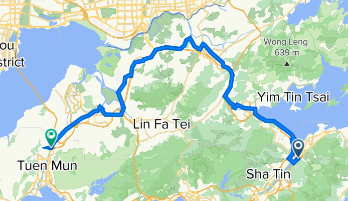
Modèle d’itinéraire
De Sha Tin à Tuen Mun

- 5 h 24 min
- Durée
- 61,3 km
- Distance
- 1 289 m
- Montée
- 1 376 m
- Descente
- 11,4 km/h
- Vit. moyenne
- 397 m
- Altitude max.
Set off from Shatin, a lively New Territories hub known for its shopping malls and riverside pathways, and pedal your way to Tuen Mun, a laid-back district with historic forts and beaches. This 61 km route takes you on a fun, varied adventure across Hong Kong’s northwestern New Territories, often following quiet roads and purpose-built cycle ways, with the bonus of only a few busy sections.
You'll gain and lose plenty of elevation en route (just over 1,200 meters climbing, and even more descending!), which means you’ll get some sweeping views—especially near the high point at almost 400 meters. About half the ride is on paved surfaces (grey tarmac or smooth asphalt), but don’t be surprised by a few rougher patches, so take a sturdy bike.
Expect plenty of greenery, village scenes, and perhaps a monkey sighting as you skirt past parks and outlying areas. Once you reach Tuen Mun, take a moment to relax along the waterfront or explore the fish market. This is a full-day ride, so bring snacks, water, and your sense of adventure!
Tours en bikepacking
Déjà découpé en étapes parfaites par notre communauté
Communauté
Meilleurs utilisateurs dans cette région


De notre communauté
Les meilleurs itinéraires à vélo de Sha Tin à Tuen Mun

From Fo Tan to Tuen Mun
Itinéraire à vélo à Sha Tin, Sha Tin, Hong Kong
- 60,9 km
- Distance
- 712 m
- Montée
- 711 m
- Descente

大圍-三聖大快活
Itinéraire à vélo à Sha Tin, Sha Tin, Hong Kong
- 33,4 km
- Distance
- 786 m
- Montée
- 786 m
- Descente


大圍-->霸尾-->上水-->河上鄉-->新田/牛潭尾軍營-->元朗-->屯門
Itinéraire à vélo à Sha Tin, Sha Tin, Hong Kong
- 69,2 km
- Distance
- 193 m
- Montée
- 177 m
- Descente

TaiWai - Taipo - Yuenlong - TuenMun
Itinéraire à vélo à Sha Tin, Sha Tin, Hong Kong
- 53,9 km
- Distance
- 114 m
- Montée
- 114 m
- Descente


Shatin to TuenMun
Itinéraire à vélo à Sha Tin, Sha Tin, Hong Kong
- 62,7 km
- Distance
- 508 m
- Montée
- 516 m
- Descente

Tuen Mun to CUHK
Itinéraire à vélo à Sha Tin, Sha Tin, Hong Kong
- 43,9 km
- Distance
- 471 m
- Montée
- 452 m
- Descente
Découvrez plus d'itinéraires
 屯馬road1.1
- Distance
- 45,9 km
- Montée
- 111 m
- Descente
- 106 m
- Emplacement
- Sha Tin, Sha Tin, Hong Kong
 20210129a
- Distance
- 58,9 km
- Montée
- 90 m
- Descente
- 116 m
- Emplacement
- Sha Tin, Sha Tin, Hong Kong
 沙田-屯門
沙田-屯門- Distance
- 56,6 km
- Montée
- 574 m
- Descente
- 583 m
- Emplacement
- Sha Tin, Sha Tin, Hong Kong
 大圍-->霸尾-->上水-->河上鄉-->新田/牛潭尾軍營-->元朗-->屯門
- Distance
- 69,2 km
- Montée
- 193 m
- Descente
- 177 m
- Emplacement
- Sha Tin, Sha Tin, Hong Kong
 TaiWai - Taipo - Yuenlong - TuenMun
- Distance
- 53,9 km
- Montée
- 114 m
- Descente
- 114 m
- Emplacement
- Sha Tin, Sha Tin, Hong Kong
 11111
11111- Distance
- 54,5 km
- Montée
- 595 m
- Descente
- 594 m
- Emplacement
- Sha Tin, Sha Tin, Hong Kong
 Shatin to TuenMun
- Distance
- 62,7 km
- Montée
- 508 m
- Descente
- 516 m
- Emplacement
- Sha Tin, Sha Tin, Hong Kong
 Tuen Mun to CUHK
- Distance
- 43,9 km
- Montée
- 471 m
- Descente
- 452 m
- Emplacement
- Sha Tin, Sha Tin, Hong Kong
Itinéraires depuis Sha Tin
Excursion à vélo d’une journée de
Sha Tin à Sai Kung
Excursion à vélo d’une journée de
Sha Tin à Yuen Long Kau Hui
À vélo de
Sha Tin à Tai Po
Itinéraires vers Tuen Mun
Excursion à vélo d’une journée de
Tsuen Wan à Tuen Mun
Excursion à vélo d’une journée de
Yuen Long Kau Hui à Tuen Mun