
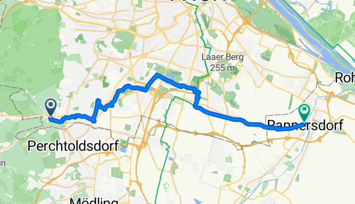
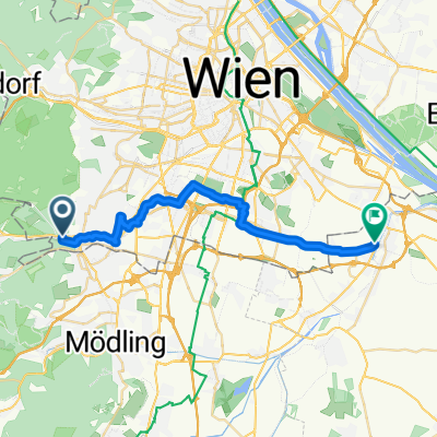
Excursion à vélo d’une journée de Perchtoldsdorf à Schwechat
Personnalise ton propre itinéraire à partir de notre modèle ou découvre comment notre communauté préfère rouler de Perchtoldsdorf à Schwechat.
Modèle d’itinéraire
De Perchtoldsdorf à Schwechat

- 1 h 30 min
- Durée
- 26,5 km
- Distance
- 121 m
- Montée
- 219 m
- Descente
- 17,7 km/h
- Vit. moyenne
- 281 m
- Altitude max.
Here’s a lovely route from Perchtoldsdorf to Schwechat that’s perfect if you want a relaxed ride through southern Vienna’s suburbs and some scenic stretches. You’ll start in Perchtoldsdorf, a historic wine town just south of Vienna, known for its charming main square and watchtower. The path runs mostly along paved surfaces (over 90% paved, with 84% asphalt), so your tires will be happy!
You’ll cover a little over 26 km with gentle rolling terrain—just enough ascent and descent (about 120 m up, nearly 220 m down) to keep things interesting without being too tough. Most of the ride follows dedicated cycleways or quiet roads, making it feel comfortable and safe. There are a few short gravel and unpaved sections, so if you ride a road bike, just take those easy.
You’ll end in Schwechat, famous for its river and Austria’s busiest airport. The town also has a brewery with a long history, so you’ve earned yourself a cold drink! Overall, it’s a scenic, accessible ride that links two interesting spots on the edge of Vienna.
Communauté
Meilleurs utilisateurs dans cette région


De notre communauté
Les meilleurs itinéraires à vélo de Perchtoldsdorf à Schwechat

Liesingbachrunde
Itinéraire à vélo à Perchtoldsdorf, Basse-Autriche, Autriche
- 14,7 km
- Distance
- 4 m
- Montée
- 56 m
- Descente

Liesing-Kaltenleutgeben-Gruberau-Trumau etc.
Itinéraire à vélo à Perchtoldsdorf, Basse-Autriche, Autriche
- 80,5 km
- Distance
- 665 m
- Montée
- 722 m
- Descente

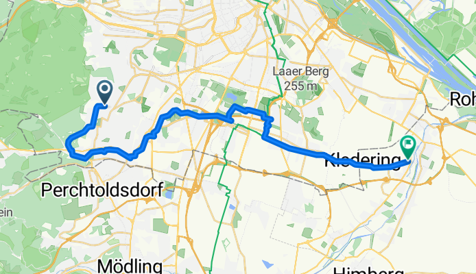
Parapluie - Liesingbach
Itinéraire à vélo à Perchtoldsdorf, Basse-Autriche, Autriche
- 56,3 km
- Distance
- 633 m
- Montée
- 695 m
- Descente

Liesing-Ölhafen Lobau und retour (50km)
Itinéraire à vélo à Perchtoldsdorf, Basse-Autriche, Autriche
- 24,2 km
- Distance
- 19 m
- Montée
- 98 m
- Descente

Breitenfurter Straße 7, Wien nach Klederinger Straße, Schwechat
Itinéraire à vélo à Perchtoldsdorf, Basse-Autriche, Autriche
- 21,1 km
- Distance
- 54 m
- Montée
- 122 m
- Descente
elg:// Liesingbachradweg (Breitenfurt-Schwechat)
Itinéraire à vélo à Perchtoldsdorf, Basse-Autriche, Autriche
- 23,4 km
- Distance
- 57 m
- Montée
- 146 m
- Descente

Schwechat
Itinéraire à vélo à Perchtoldsdorf, Basse-Autriche, Autriche
- 14,4 km
- Distance
- 166 m
- Montée
- 251 m
- Descente
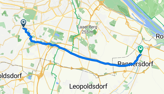
Leitengasse, Wien nach Brauhausstraße, Schwechat
Itinéraire à vélo à Perchtoldsdorf, Basse-Autriche, Autriche
- 26,5 km
- Distance
- 107 m
- Montée
- 198 m
- Descente

liesingbach
Itinéraire à vélo à Perchtoldsdorf, Basse-Autriche, Autriche
- 20,2 km
- Distance
- 5 m
- Montée
- 62 m
- Descente
Schwechat
Itinéraire à vélo à Perchtoldsdorf, Basse-Autriche, Autriche
- 15,5 km
- Distance
- 10 m
- Montée
- 74 m
- Descente

Erbsenflughafen
Itinéraire à vélo à Perchtoldsdorf, Basse-Autriche, Autriche
- 56,8 km
- Distance
- 246 m
- Montée
- 301 m
- Descente
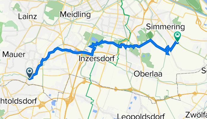
Rundumadum: Liesing - Zentralfriedhof
Itinéraire à vélo à Perchtoldsdorf, Basse-Autriche, Autriche
- 16,7 km
- Distance
- 103 m
- Montée
- 154 m
- Descente
Découvrez plus d'itinéraires
 Breitenfurter Straße 7, Wien nach Klederinger Straße, Schwechat
- Distance
- 21,1 km
- Montée
- 54 m
- Descente
- 122 m
- Emplacement
- Perchtoldsdorf, Basse-Autriche, Autriche
 elg:// Liesingbachradweg (Breitenfurt-Schwechat)
- Distance
- 23,4 km
- Montée
- 57 m
- Descente
- 146 m
- Emplacement
- Perchtoldsdorf, Basse-Autriche, Autriche
 Schwechat
- Distance
- 14,4 km
- Montée
- 166 m
- Descente
- 251 m
- Emplacement
- Perchtoldsdorf, Basse-Autriche, Autriche
 Leitengasse, Wien nach Brauhausstraße, Schwechat
- Distance
- 26,5 km
- Montée
- 107 m
- Descente
- 198 m
- Emplacement
- Perchtoldsdorf, Basse-Autriche, Autriche
 liesingbach
- Distance
- 20,2 km
- Montée
- 5 m
- Descente
- 62 m
- Emplacement
- Perchtoldsdorf, Basse-Autriche, Autriche
 Schwechat
- Distance
- 15,5 km
- Montée
- 10 m
- Descente
- 74 m
- Emplacement
- Perchtoldsdorf, Basse-Autriche, Autriche
 Erbsenflughafen
- Distance
- 56,8 km
- Montée
- 246 m
- Descente
- 301 m
- Emplacement
- Perchtoldsdorf, Basse-Autriche, Autriche
 Rundumadum: Liesing - Zentralfriedhof
- Distance
- 16,7 km
- Montée
- 103 m
- Descente
- 154 m
- Emplacement
- Perchtoldsdorf, Basse-Autriche, Autriche
Itinéraires depuis Perchtoldsdorf
Excursion à vélo d’une journée de
Perchtoldsdorf à Purkersdorf
Sortie rapide à vélo de
Perchtoldsdorf à Vienne
Sortie rapide à vélo de
Perchtoldsdorf à Kaltenleutgeben
Itinéraires vers Schwechat
Excursion à vélo d’une journée de
Gerasdorf bei Wien à Schwechat
Sortie rapide à vélo de
Vösendorf à Schwechat
Sortie rapide à vélo de
Vienne à Schwechat