
Modèle d’itinéraire
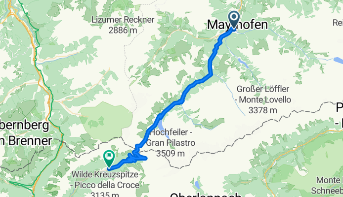
De Mayrhofen à Ried

- 10 h 11 min
- Durée
- 148,1 km
- Distance
- 3 216 m
- Montée
- 2 482 m
- Descente
- 14,5 km/h
- Vit. moyenne
- 1 408 m
- Altitude max.
This spectacular ride kicks off in Mayrhofen, a vibrant Tyrolean village famous for its alpine charm and as a ski and hiking hub. You'll be pedaling south through the stunning Zillertal valley, surrounded by jagged peaks – don’t forget to take in the scenery!
The route covers about 148 km and is pretty challenging, with over 3,200 meters of climbing, so be ready for those mountain passes. Thankfully, most of your journey rolls along paved roads, many of which are quiet and perfect for soaking up the views. Expect some sections on local tracks and designated cycleways too.
After some serious pedal pushing through alpine landscapes, you’ll make your way down towards Ried, a peaceful spot in the Oberinntal, perfect for a relaxing finish. This area is less touristy, giving you a nice contrast to busy Mayrhofen.
Keep in mind the elevation – the highest point is above 1,400 meters, so pack for changing weather and bring plenty of snacks. Mayrhofen’s energy at the start and Ried’s tranquility at the end make this a rewarding alpine adventure. Happy cycling!
Communauté
Meilleurs utilisateurs dans cette région


De notre communauté
Les meilleurs itinéraires à vélo de Mayrhofen à Ried

Alpencross Teil 3
Itinéraire à vélo à Mayrhofen, Tyrol, Autriche
- 27,9 km
- Distance
- 1 250 m
- Montée
- 804 m
- Descente

Transalp 2015 - Etappe 2
Itinéraire à vélo à Mayrhofen, Tyrol, Autriche
- 31,1 km
- Distance
- 1 891 m
- Montée
- 269 m
- Descente


3-Forstweg. Mü-Ve - Ginzling - St. Jakob (Fussendrass)
Itinéraire à vélo à Mayrhofen, Tyrol, Autriche
- 33,6 km
- Distance
- 1 262 m
- Montée
- 791 m
- Descente

3-Trail. Mü-Ve - Ginzling - St. Jakob (Fussendrass)
Itinéraire à vélo à Mayrhofen, Tyrol, Autriche
- 28,1 km
- Distance
- 1 277 m
- Montée
- 810 m
- Descente

Mayrhofen - St. Jakob - MüVe3
Itinéraire à vélo à Mayrhofen, Tyrol, Autriche
- 43,9 km
- Distance
- 1 607 m
- Montée
- 808 m
- Descente

18729 Mayhofen Sterzing
Itinéraire à vélo à Mayrhofen, Tyrol, Autriche
- 27,2 km
- Distance
- 1 261 m
- Montée
- 799 m
- Descente

Mayrhofen - Pfitscherjoch CLONED FROM ROUTE 53995
Itinéraire à vélo à Mayrhofen, Tyrol, Autriche
- 29 km
- Distance
- 1 597 m
- Montée
- 370 m
- Descente


2018_D-Ven_Tag2_Fussendrass
Itinéraire à vélo à Mayrhofen, Tyrol, Autriche
- 48 km
- Distance
- 1 633 m
- Montée
- 879 m
- Descente

3 VAR_Pfitscher Joch: Vorderlanersbach-Fußendrass 1600Hm 55km
Itinéraire à vélo à Mayrhofen, Tyrol, Autriche
- 54,9 km
- Distance
- 1 478 m
- Montée
- 1 342 m
- Descente
Découvrez plus d'itinéraires
 3-Trail. Mü-Ve - Ginzling - St. Jakob (Fussendrass)
- Distance
- 28,1 km
- Montée
- 1 277 m
- Descente
- 810 m
- Emplacement
- Mayrhofen, Tyrol, Autriche
 Pfitscherjoch
- Distance
- 33 km
- Montée
- 1 506 m
- Descente
- 974 m
- Emplacement
- Mayrhofen, Tyrol, Autriche
 Mayrhofen - St. Jakob - MüVe3
- Distance
- 43,9 km
- Montée
- 1 607 m
- Descente
- 808 m
- Emplacement
- Mayrhofen, Tyrol, Autriche
 18729 Mayhofen Sterzing
- Distance
- 27,2 km
- Montée
- 1 261 m
- Descente
- 799 m
- Emplacement
- Mayrhofen, Tyrol, Autriche
 Mayrhofen - Pfitscherjoch CLONED FROM ROUTE 53995
- Distance
- 29 km
- Montée
- 1 597 m
- Descente
- 370 m
- Emplacement
- Mayrhofen, Tyrol, Autriche
 Alt Teil 2
- Distance
- 42,1 km
- Montée
- 1 635 m
- Descente
- 848 m
- Emplacement
- Mayrhofen, Tyrol, Autriche
 2018_D-Ven_Tag2_Fussendrass
- Distance
- 48 km
- Montée
- 1 633 m
- Descente
- 879 m
- Emplacement
- Mayrhofen, Tyrol, Autriche
 3 VAR_Pfitscher Joch: Vorderlanersbach-Fußendrass 1600Hm 55km
- Distance
- 54,9 km
- Montée
- 1 478 m
- Descente
- 1 342 m
- Emplacement
- Mayrhofen, Tyrol, Autriche
Itinéraires depuis Mayrhofen
Excursion à vélo d’une journée de
Mayrhofen à Schmirn