
Excursion à vélo d’une journée de Heiligenblut à Bruck an der Grossglocknerstrasse
Personnalise ton propre itinéraire à partir de notre modèle ou découvre comment notre communauté préfère rouler de Heiligenblut à Bruck an der Grossglocknerstrasse.
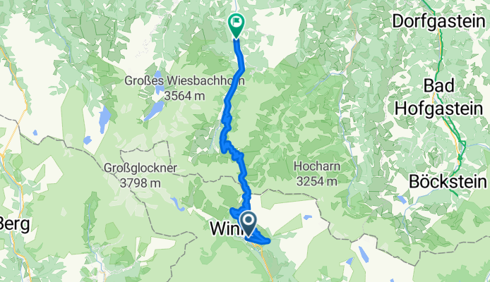
Modèle d’itinéraire
De Heiligenblut à Bruck an der Grossglocknerstrasse

- 3 h 45 min
- Durée
- 47,3 km
- Distance
- 1 972 m
- Montée
- 2 496 m
- Descente
- 12,6 km/h
- Vit. moyenne
- 2 531 m
- Altitude max.
This epic ride kicks off in Heiligenblut am Großglockner, a charming alpine village famous for its dramatic backdrop—the mighty Großglockner, Austria’s tallest peak. Right from the start, you’ll be climbing hard: expect nearly 2000 meters of ascent as you wind along some of the country's most scenic (and leg-burning) mountain roads.
The majority of this 47 km route has blissfully smooth asphalt, and you'll crest the famous Großglockner High Alpine Road, one of Europe’s top bucket-list climbs and a true paradise for cycling enthusiasts. Prepare for jaw-dropping views, snowy peaks (even in summer!), and perhaps a marmot or two cheering you on.
From the summit, soak in reaching a max elevation over 2500 meters before descending all the way to Bruck an der Großglocknerstraße. The ride down is a just reward—long, fast, and flanked by stunning valleys. In Bruck, the landscape softens; it’s a welcoming spot for a post-ride coffee and to relive your adventure.
Definitely bring layers—the weather can change fast! This route is legendary, so take your time and enjoy every switchback.
Communauté
Meilleurs utilisateurs dans cette région


De notre communauté
Les meilleurs itinéraires à vélo de Heiligenblut à Bruck an der Grossglocknerstrasse

TA18E#7neux
Itinéraire à vélo à Heiligenblut, Carinthie, Autriche
- 51,1 km
- Distance
- 1 727 m
- Montée
- 2 137 m
- Descente

TA18E#7oldx
Itinéraire à vélo à Heiligenblut, Carinthie, Autriche
- 52,4 km
- Distance
- 1 503 m
- Montée
- 2 189 m
- Descente

TA18E#7neuxx
Itinéraire à vélo à Heiligenblut, Carinthie, Autriche
- 52,3 km
- Distance
- 1 751 m
- Montée
- 2 161 m
- Descente

Grossglockner - Heiligenblut-Fusch
Itinéraire à vélo à Heiligenblut, Carinthie, Autriche
- 42,7 km
- Distance
- 1 724 m
- Montée
- 2 204 m
- Descente

Heiligenblut - Fusch an der Grossglocknerstrasse
Itinéraire à vélo à Heiligenblut, Carinthie, Autriche
- 43,2 km
- Distance
- 1 420 m
- Montée
- 1 845 m
- Descente

(7)Hblut - Bruck
Itinéraire à vélo à Heiligenblut, Carinthie, Autriche
- 49,3 km
- Distance
- 1 609 m
- Montée
- 2 105 m
- Descente

Austria
Itinéraire à vélo à Heiligenblut, Carinthie, Autriche
- 67,6 km
- Distance
- 2 095 m
- Montée
- 2 629 m
- Descente

Grossglochner 2
Itinéraire à vélo à Heiligenblut, Carinthie, Autriche
- 40,9 km
- Distance
- 858 m
- Montée
- 2 382 m
- Descente
Naj cesta u europi
Itinéraire à vélo à Heiligenblut, Carinthie, Autriche
- 40,8 km
- Distance
- 1 431 m
- Montée
- 1 904 m
- Descente

Kaiser F.Josef
Itinéraire à vélo à Heiligenblut, Carinthie, Autriche
- 41,2 km
- Distance
- 844 m
- Montée
- 2 378 m
- Descente

Großglockner2
Itinéraire à vélo à Heiligenblut, Carinthie, Autriche
- 44,9 km
- Distance
- 1 543 m
- Montée
- 2 053 m
- Descente

kaiser franz hütte- fusch visszaút
Itinéraire à vélo à Heiligenblut, Carinthie, Autriche
- 41,2 km
- Distance
- 995 m
- Montée
- 2 539 m
- Descente
Découvrez plus d'itinéraires
 Heiligenblut - Fusch an der Grossglocknerstrasse
- Distance
- 43,2 km
- Montée
- 1 420 m
- Descente
- 1 845 m
- Emplacement
- Heiligenblut, Carinthie, Autriche
 (7)Hblut - Bruck
- Distance
- 49,3 km
- Montée
- 1 609 m
- Descente
- 2 105 m
- Emplacement
- Heiligenblut, Carinthie, Autriche
 Austria
- Distance
- 67,6 km
- Montée
- 2 095 m
- Descente
- 2 629 m
- Emplacement
- Heiligenblut, Carinthie, Autriche
 Grossglochner 2
- Distance
- 40,9 km
- Montée
- 858 m
- Descente
- 2 382 m
- Emplacement
- Heiligenblut, Carinthie, Autriche
 Naj cesta u europi
- Distance
- 40,8 km
- Montée
- 1 431 m
- Descente
- 1 904 m
- Emplacement
- Heiligenblut, Carinthie, Autriche
 Kaiser F.Josef
- Distance
- 41,2 km
- Montée
- 844 m
- Descente
- 2 378 m
- Emplacement
- Heiligenblut, Carinthie, Autriche
 Großglockner2
- Distance
- 44,9 km
- Montée
- 1 543 m
- Descente
- 2 053 m
- Emplacement
- Heiligenblut, Carinthie, Autriche
 kaiser franz hütte- fusch visszaút
- Distance
- 41,2 km
- Montée
- 995 m
- Descente
- 2 539 m
- Emplacement
- Heiligenblut, Carinthie, Autriche
Itinéraires depuis Heiligenblut
Excursion à vélo d’une journée de
Heiligenblut à Zell am See
Itinéraires vers Bruck an der Grossglocknerstrasse
Excursion à vélo d’une journée de
Krimml à Bruck an der Grossglocknerstrasse