

Sortie rapide à vélo de Stolberg à Aix-la-Chapelle
Personnalise ton propre itinéraire à partir de notre modèle ou découvre comment notre communauté préfère rouler de Stolberg à Aix-la-Chapelle.
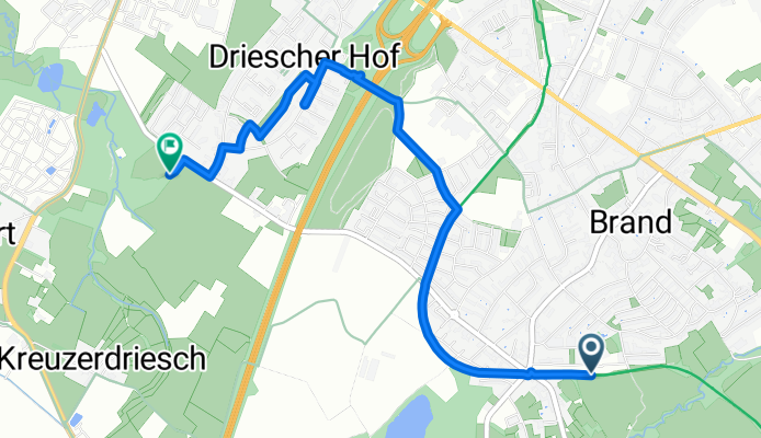
Modèle d’itinéraire
De Stolberg à Aix-la-Chapelle

- 1 h 4 min
- Durée
- 18,3 km
- Distance
- 149 m
- Montée
- 158 m
- Descente
- 17,2 km/h
- Vit. moyenne
- 243 m
- Altitude max.
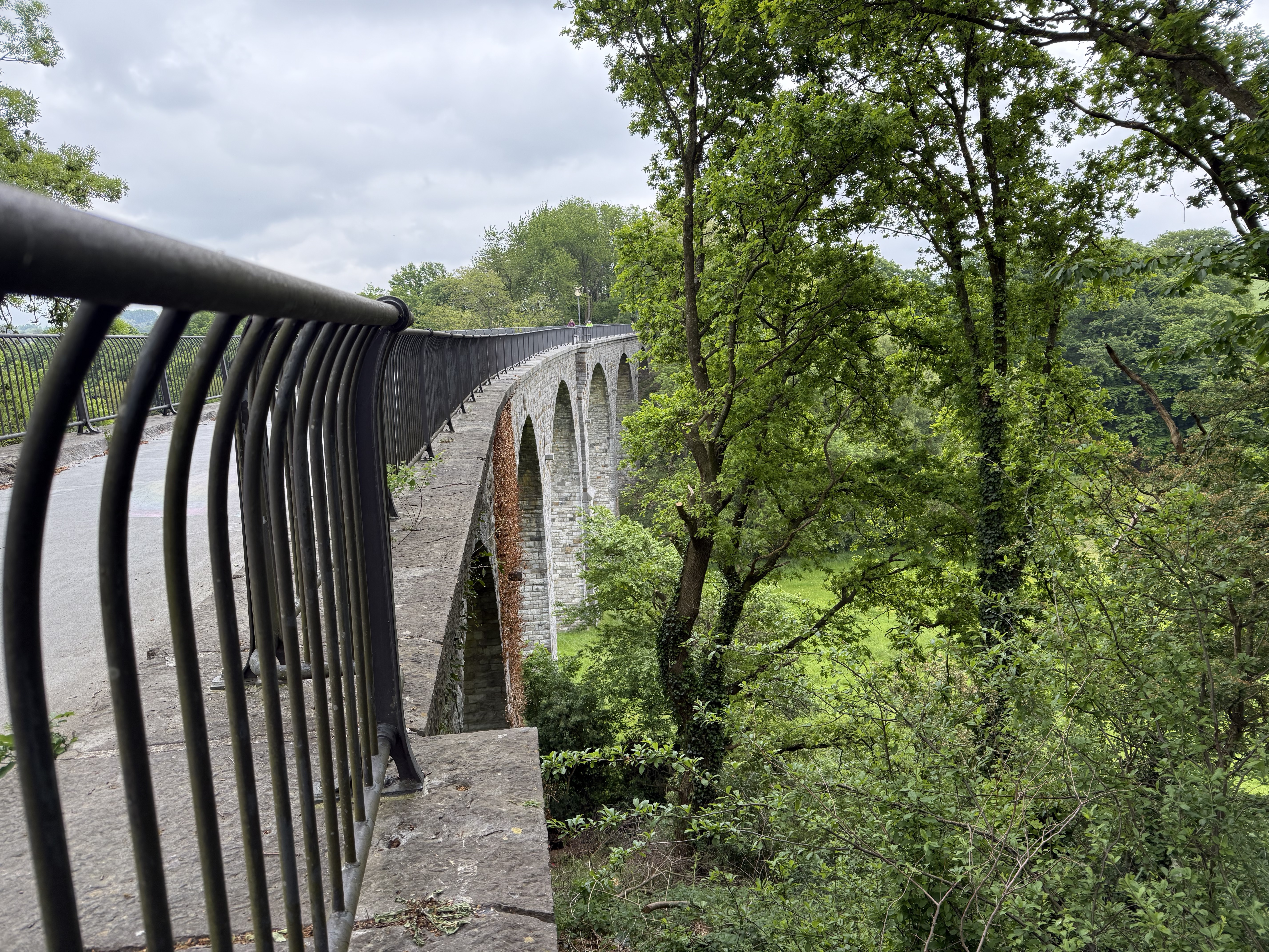
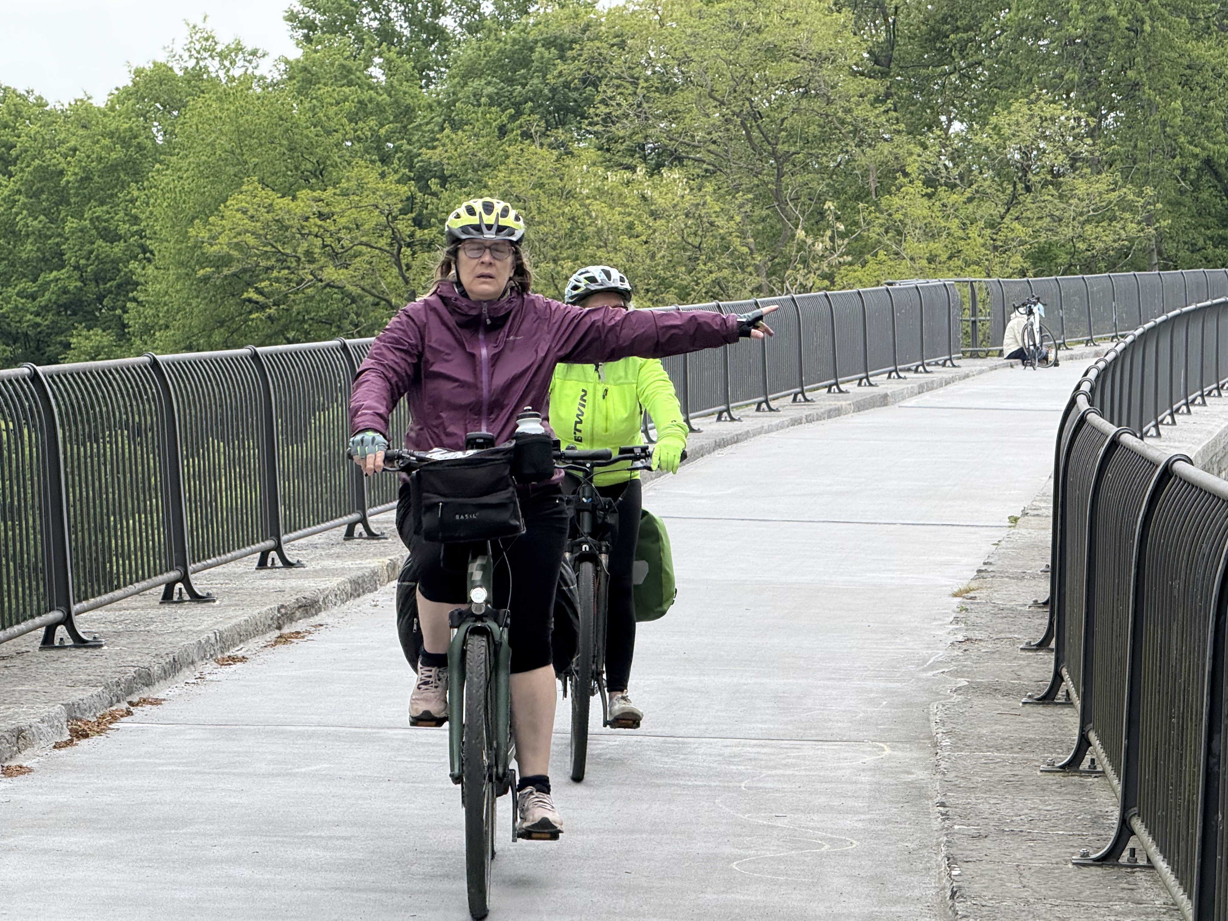
Get ready for a scenic ride from Stolberg to Aachen! Starting in Stolberg, a charming town known for its medieval castle and beautiful old town, the route stretches just over 18 km, taking you west towards the vibrant city of Aachen. Expect mostly smooth sailing: about 85% of the surfaces are paved, with the lion’s share being nice, rolling asphalt.
The ride includes gentle ascents and descents (around 150 meters up, 158 meters down), making it suitable for most cyclists with a bit of stamina. You’ll cruise along quiet roads and dedicated cycling paths for much of the journey—so there’s plenty of opportunity to take it easy and soak in the countryside views.
Once you roll into Aachen, you’ll find yourself in a city famous for its impressive cathedral (a UNESCO site), lively student scene, and top-notch bakeries. Whether you’re in it for the history or the pastries, finishing your ride in Aachen is the perfect reward. Don’t forget to bring your camera and maybe stop for a coffee along the way!
Communauté
Meilleurs utilisateurs dans cette région


De notre communauté
Les meilleurs itinéraires à vélo de Stolberg à Aix-la-Chapelle

Kornelimunster to Bahnhofplatz, Aachen
Itinéraire à vélo à Stolberg, Rhénanie du Nord-Westphalie, Allemagne
- 20 km
- Distance
- 137 m
- Montée
- 196 m
- Descente

Mausbach - Eilendorf
Itinéraire à vélo à Stolberg, Rhénanie du Nord-Westphalie, Allemagne
- 17,2 km
- Distance
- 147 m
- Montée
- 179 m
- Descente

Von Camp Astrid zu Misereor
Itinéraire à vélo à Stolberg, Rhénanie du Nord-Westphalie, Allemagne
- 16,2 km
- Distance
- 77 m
- Montée
- 117 m
- Descente

Brand - Entenpfuhl
Itinéraire à vélo à Stolberg, Rhénanie du Nord-Westphalie, Allemagne
- 16 km
- Distance
- 194 m
- Montée
- 125 m
- Descente

Aachen-Brand zum Dom über Nebenstrecke
Itinéraire à vélo à Stolberg, Rhénanie du Nord-Westphalie, Allemagne
- 7,5 km
- Distance
- 17 m
- Montée
- 104 m
- Descente

Beckerstraße nach Lintertstraße
Itinéraire à vélo à Stolberg, Rhénanie du Nord-Westphalie, Allemagne
- 4,2 km
- Distance
- 7 m
- Montée
- 69 m
- Descente

Mausbach-Donnerberg-Atsch-Eilendorf
Itinéraire à vélo à Stolberg, Rhénanie du Nord-Westphalie, Allemagne
- 13,6 km
- Distance
- 121 m
- Montée
- 175 m
- Descente

Aachen-Brand zum Dom über Vennbahn
Itinéraire à vélo à Stolberg, Rhénanie du Nord-Westphalie, Allemagne
- 8,8 km
- Distance
- 4 m
- Montée
- 94 m
- Descente

Katzhecke 4, Stolberg (Rheinland) nach Am Gut Wolf 2B, Aachen
Itinéraire à vélo à Stolberg, Rhénanie du Nord-Westphalie, Allemagne
- 12,6 km
- Distance
- 78 m
- Montée
- 125 m
- Descente

BOE Rolf
Itinéraire à vélo à Stolberg, Rhénanie du Nord-Westphalie, Allemagne
- 30,9 km
- Distance
- 177 m
- Montée
- 204 m
- Descente

Kornelimünster - Aachen Kapuzinerkarree
Itinéraire à vélo à Stolberg, Rhénanie du Nord-Westphalie, Allemagne
- 12 km
- Distance
- 51 m
- Montée
- 126 m
- Descente

Trierer Straße 686, Aachen nach Panneschopp 7, Kelmis
Itinéraire à vélo à Stolberg, Rhénanie du Nord-Westphalie, Allemagne
- 15,1 km
- Distance
- 165 m
- Montée
- 168 m
- Descente
Découvrez plus d'itinéraires
 Aachen-Brand zum Dom über Nebenstrecke
- Distance
- 7,5 km
- Montée
- 17 m
- Descente
- 104 m
- Emplacement
- Stolberg, Rhénanie du Nord-Westphalie, Allemagne
 Beckerstraße nach Lintertstraße
- Distance
- 4,2 km
- Montée
- 7 m
- Descente
- 69 m
- Emplacement
- Stolberg, Rhénanie du Nord-Westphalie, Allemagne
 Mausbach-Donnerberg-Atsch-Eilendorf
- Distance
- 13,6 km
- Montée
- 121 m
- Descente
- 175 m
- Emplacement
- Stolberg, Rhénanie du Nord-Westphalie, Allemagne
 Aachen-Brand zum Dom über Vennbahn
- Distance
- 8,8 km
- Montée
- 4 m
- Descente
- 94 m
- Emplacement
- Stolberg, Rhénanie du Nord-Westphalie, Allemagne
 Katzhecke 4, Stolberg (Rheinland) nach Am Gut Wolf 2B, Aachen
- Distance
- 12,6 km
- Montée
- 78 m
- Descente
- 125 m
- Emplacement
- Stolberg, Rhénanie du Nord-Westphalie, Allemagne
 BOE Rolf
- Distance
- 30,9 km
- Montée
- 177 m
- Descente
- 204 m
- Emplacement
- Stolberg, Rhénanie du Nord-Westphalie, Allemagne
 Kornelimünster - Aachen Kapuzinerkarree
- Distance
- 12 km
- Montée
- 51 m
- Descente
- 126 m
- Emplacement
- Stolberg, Rhénanie du Nord-Westphalie, Allemagne
 Trierer Straße 686, Aachen nach Panneschopp 7, Kelmis
- Distance
- 15,1 km
- Montée
- 165 m
- Descente
- 168 m
- Emplacement
- Stolberg, Rhénanie du Nord-Westphalie, Allemagne
Itinéraires depuis Stolberg
Sortie rapide à vélo de
Stolberg à Würselen
Itinéraires vers Aix-la-Chapelle
Excursion à vélo d’une journée de
Roetgen à Aix-la-Chapelle
Excursion à vélo d’une journée de
Troisvierges à Aix-la-Chapelle
Sortie rapide à vélo de
Alsdorf à Aix-la-Chapelle
Sortie rapide à vélo de
Würselen à Aix-la-Chapelle