
Sortie rapide à vélo de Rednitzhembach à Feucht
Personnalise ton propre itinéraire à partir de notre modèle ou découvre comment notre communauté préfère rouler de Rednitzhembach à Feucht.
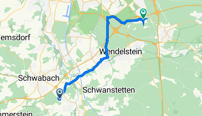
Modèle d’itinéraire
De Rednitzhembach à Feucht

- 1 h 12 min
- Durée
- 17,4 km
- Distance
- 157 m
- Montée
- 123 m
- Descente
- 14,5 km/h
- Vit. moyenne
- 369 m
- Altitude max.
Rednitzhembach to Feucht Cycling Route
If you’re looking for a relaxing ride through the Franconian countryside, this 17.4 km stretch from Rednitzhembach to Feucht is a perfect pick. Starting in Rednitzhembach, a laid-back town nestled along the Rednitz river, you’ll roll out on mostly quiet roads and well-maintained tracks. The route is a nice mix of 63% paved (mainly asphalt) and about a quarter on smooth gravel, so a sturdy hybrid or gravel bike is a good choice.
You’ll climb a gentle 157 meters overall—nothing too daunting, just enough to earn those spectacular country views. Expect plenty of peaceful moments among fields, woodland, and the occasional charming village. Feucht, your destination, is known for its historic bee-keeping tradition (check out the Zeidelmuseum if you’ve got time) and cozy Franconian flair.
With barely any busy roads and the bulk of riding on quiet, low-traffic stretches and country paths, this route is ideal for those who want to unwind and enjoy the scenery. Don’t forget to pack some snacks and maybe stop for coffee in Feucht!
Communauté
Meilleurs utilisateurs dans cette région


De notre communauté
Les meilleurs itinéraires à vélo de Rednitzhembach à Feucht

An der Maisenlach 59G, Rednitzhembach nach Am Tower 11, Nürnberg
Itinéraire à vélo à Rednitzhembach, Bavière, Allemagne
- 17,4 km
- Distance
- 416 m
- Montée
- 388 m
- Descente

An der Maisenlach 59G, Rednitzhembach nach Am Keuper 1, Nürnberg
Itinéraire à vélo à Rednitzhembach, Bavière, Allemagne
- 17,6 km
- Distance
- 443 m
- Montée
- 417 m
- Descente

An der Maisenlach 59H, Rednitzhembach nach Am Keuper 1, Nürnberg
Itinéraire à vélo à Rednitzhembach, Bavière, Allemagne
- 17,1 km
- Distance
- 441 m
- Montée
- 428 m
- Descente

An der Maisenlach 59 G, Rednitzhembach nach Am Keuper 1, Nürnberg
Itinéraire à vélo à Rednitzhembach, Bavière, Allemagne
- 17,1 km
- Distance
- 436 m
- Montée
- 409 m
- Descente

An der Maisenlach 59G, Rednitzhembach nach Am Keuper 1, Nürnberg
Itinéraire à vélo à Rednitzhembach, Bavière, Allemagne
- 17,2 km
- Distance
- 245 m
- Montée
- 251 m
- Descente
An der Maisenlach 59G, Rednitzhembach nach Am Keuper 3, Nürnberg
Itinéraire à vélo à Rednitzhembach, Bavière, Allemagne
- 17,2 km
- Distance
- 401 m
- Montée
- 377 m
- Descente

An der Maisenlach 59G, Rednitzhembach nach Am Tower 11, Nürnberg
Itinéraire à vélo à Rednitzhembach, Bavière, Allemagne
- 17,1 km
- Distance
- 353 m
- Montée
- 351 m
- Descente

An der Maisenlach 59G, Rednitzhembach nach Am Keuper 1, Nürnberg
Itinéraire à vélo à Rednitzhembach, Bavière, Allemagne
- 17 km
- Distance
- 275 m
- Montée
- 283 m
- Descente

An der Maisenlach 59G, Rednitzhembach nach Am Keuper 1, Nürnberg
Itinéraire à vélo à Rednitzhembach, Bavière, Allemagne
- 19,3 km
- Distance
- 375 m
- Montée
- 368 m
- Descente

An der Maisenlach 59G, Rednitzhembach nach Am Tower 11, Nürnberg
Itinéraire à vélo à Rednitzhembach, Bavière, Allemagne
- 17,2 km
- Distance
- 410 m
- Montée
- 435 m
- Descente

An der Maisenlach G, Rednitzhembach nach Am Keuper 1, Nürnberg
Itinéraire à vélo à Rednitzhembach, Bavière, Allemagne
- 17,1 km
- Distance
- 343 m
- Montée
- 322 m
- Descente

An der Maisenlach 59G, Rednitzhembach nach Am Keuper 1, Nürnberg
Itinéraire à vélo à Rednitzhembach, Bavière, Allemagne
- 17,1 km
- Distance
- 350 m
- Montée
- 343 m
- Descente
Découvrez plus d'itinéraires
 An der Maisenlach 59G, Rednitzhembach nach Am Keuper 1, Nürnberg
- Distance
- 17,2 km
- Montée
- 245 m
- Descente
- 251 m
- Emplacement
- Rednitzhembach, Bavière, Allemagne
 An der Maisenlach 59G, Rednitzhembach nach Am Keuper 3, Nürnberg
- Distance
- 17,2 km
- Montée
- 401 m
- Descente
- 377 m
- Emplacement
- Rednitzhembach, Bavière, Allemagne
 An der Maisenlach 59G, Rednitzhembach nach Am Tower 11, Nürnberg
- Distance
- 17,1 km
- Montée
- 353 m
- Descente
- 351 m
- Emplacement
- Rednitzhembach, Bavière, Allemagne
 An der Maisenlach 59G, Rednitzhembach nach Am Keuper 1, Nürnberg
- Distance
- 17 km
- Montée
- 275 m
- Descente
- 283 m
- Emplacement
- Rednitzhembach, Bavière, Allemagne
 An der Maisenlach 59G, Rednitzhembach nach Am Keuper 1, Nürnberg
- Distance
- 19,3 km
- Montée
- 375 m
- Descente
- 368 m
- Emplacement
- Rednitzhembach, Bavière, Allemagne
 An der Maisenlach 59G, Rednitzhembach nach Am Tower 11, Nürnberg
- Distance
- 17,2 km
- Montée
- 410 m
- Descente
- 435 m
- Emplacement
- Rednitzhembach, Bavière, Allemagne
 An der Maisenlach G, Rednitzhembach nach Am Keuper 1, Nürnberg
- Distance
- 17,1 km
- Montée
- 343 m
- Descente
- 322 m
- Emplacement
- Rednitzhembach, Bavière, Allemagne
 An der Maisenlach 59G, Rednitzhembach nach Am Keuper 1, Nürnberg
- Distance
- 17,1 km
- Montée
- 350 m
- Descente
- 343 m
- Emplacement
- Rednitzhembach, Bavière, Allemagne
Itinéraires vers Feucht
Sortie rapide à vélo de
Nuremberg à Feucht