
Excursion à vélo d’une journée de Mittenwald à Innsbruck
Personnalise ton propre itinéraire à partir de notre modèle ou découvre comment notre communauté préfère rouler de Mittenwald à Innsbruck.
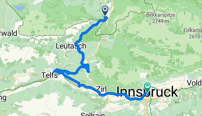
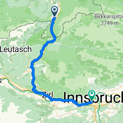
Modèle d’itinéraire
De Mittenwald à Innsbruck

- 3 h 47 min
- Durée
- 62,1 km
- Distance
- 637 m
- Montée
- 970 m
- Descente
- 16,4 km/h
- Vit. moyenne
- 1 278 m
- Altitude max.
Ready for an epic ride? This route takes you from the charming Bavarian town of Mittenwald to the lively city of Innsbruck in Austria. You’ll cover about 62 kilometers, weaving your way through some seriously stunning Alpine scenery.
Mittenwald, famous for its colorful painted houses and violin-making history, sits at the foot of the Karwendel mountains. The journey south rolls mostly on smooth asphalt and paved roads, with short sections of gravel to keep things interesting. You’ll climb just over 630 meters—enough to get your heart pumping but not too brutal—and descend nearly 970 meters as you head into the Inn valley.
You’ll ride tracks and quiet roads for the most part, with only brief stretches alongside busier traffic, and you’ll pass through lush valleys and postcard-worthy mountain views. Innsbruck welcomes you at the end—a city known for its medieval old town, vibrant café life, and as an epicenter of winter sports.
All in all, it’s a fantastic cross-border ride with a good mix of terrain and plenty of Alpine magic. Don’t forget your camera!
Communauté
Meilleurs utilisateurs dans cette région


De notre communauté
Les meilleurs itinéraires à vélo de Mittenwald à Innsbruck

kurz Miwa Innsbruck
Itinéraire à vélo à Mittenwald, Bavière, Allemagne
- 50,7 km
- Distance
- 640 m
- Montée
- 877 m
- Descente

552. Seefelder Sattel, Umweg - Nebel - Regen und Brenner/ Passo del Brennero
Itinéraire à vélo à Mittenwald, Bavière, Allemagne
- 139 km
- Distance
- 2 437 m
- Montée
- 2 768 m
- Descente

Karwendelroute
Itinéraire à vélo à Mittenwald, Bavière, Allemagne
- 177,8 km
- Distance
- 1 689 m
- Montée
- 2 016 m
- Descente

Mittenwald - Kühtai -Innsbruck
Itinéraire à vélo à Mittenwald, Bavière, Allemagne
- 116,6 km
- Distance
- 1 884 m
- Montée
- 2 218 m
- Descente

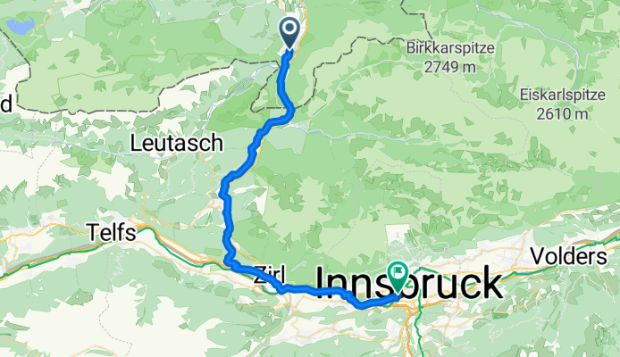
Mittenwald- Innsbruck Tag1
Itinéraire à vélo à Mittenwald, Bavière, Allemagne
- 58 km
- Distance
- 633 m
- Montée
- 962 m
- Descente
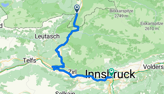
Mittenwald - Innsbruck
Itinéraire à vélo à Mittenwald, Bavière, Allemagne
- 67,1 km
- Distance
- 381 m
- Montée
- 729 m
- Descente

bis Innsbruck
Itinéraire à vélo à Mittenwald, Bavière, Allemagne
- 40,7 km
- Distance
- 323 m
- Montée
- 666 m
- Descente
Mittenwald Bahnhofpl. nach Rechengasse
Itinéraire à vélo à Mittenwald, Bavière, Allemagne
- 40,5 km
- Distance
- 485 m
- Montée
- 827 m
- Descente

Mittenwald-Innsbruck
Itinéraire à vélo à Mittenwald, Bavière, Allemagne
- 36 km
- Distance
- 394 m
- Montée
- 732 m
- Descente
From Mittenwald to Innsbruck
Itinéraire à vélo à Mittenwald, Bavière, Allemagne
- 49,8 km
- Distance
- 547 m
- Montée
- 880 m
- Descente

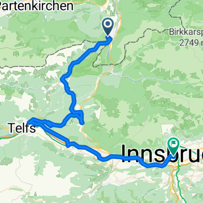
MIttenwald-Innsbruck via Telfs
Itinéraire à vélo à Mittenwald, Bavière, Allemagne
- 58,8 km
- Distance
- 609 m
- Montée
- 938 m
- Descente

Achensee mit Zillertal
Itinéraire à vélo à Mittenwald, Bavière, Allemagne
- 157,2 km
- Distance
- 1 336 m
- Montée
- 1 669 m
- Descente
Découvrez plus d'itinéraires
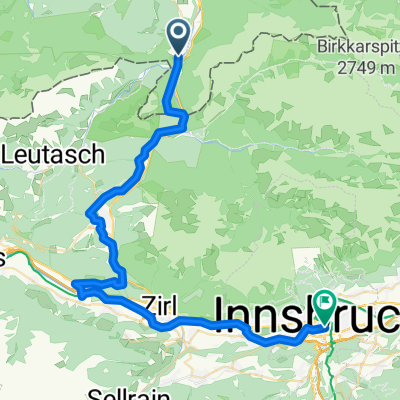
 Mittenwald- Innsbruck Tag1
- Distance
- 58 km
- Montée
- 633 m
- Descente
- 962 m
- Emplacement
- Mittenwald, Bavière, Allemagne
 Mittenwald - Innsbruck
- Distance
- 67,1 km
- Montée
- 381 m
- Descente
- 729 m
- Emplacement
- Mittenwald, Bavière, Allemagne
 bis Innsbruck
- Distance
- 40,7 km
- Montée
- 323 m
- Descente
- 666 m
- Emplacement
- Mittenwald, Bavière, Allemagne
 Mittenwald Bahnhofpl. nach Rechengasse
- Distance
- 40,5 km
- Montée
- 485 m
- Descente
- 827 m
- Emplacement
- Mittenwald, Bavière, Allemagne
 Mittenwald-Innsbruck
- Distance
- 36 km
- Montée
- 394 m
- Descente
- 732 m
- Emplacement
- Mittenwald, Bavière, Allemagne
 From Mittenwald to Innsbruck
- Distance
- 49,8 km
- Montée
- 547 m
- Descente
- 880 m
- Emplacement
- Mittenwald, Bavière, Allemagne
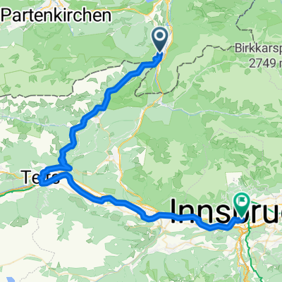 MIttenwald-Innsbruck via Telfs
- Distance
- 58,8 km
- Montée
- 609 m
- Descente
- 938 m
- Emplacement
- Mittenwald, Bavière, Allemagne
 Achensee mit Zillertal
- Distance
- 157,2 km
- Montée
- 1 336 m
- Descente
- 1 669 m
- Emplacement
- Mittenwald, Bavière, Allemagne
Itinéraires depuis Mittenwald
Excursion à vélo d’une journée de
Mittenwald à Bad Tölz
Excursion à vélo d’une journée de
Mittenwald à Garmisch-Partenkirchen
Sortie rapide à vélo de
Mittenwald à Scharnitz
Itinéraires vers Innsbruck
Bikepacking de
Bolzano à Innsbruck
Bikepacking de
Salzbourg à Innsbruck
Excursion à vélo d’une journée de
Vipiteno à Innsbruck
Excursion à vélo d’une journée de
Gries am Brenner à Innsbruck
Sortie rapide à vélo de
Völs à Innsbruck
Sortie rapide à vélo de
Hall en Tyrol à Innsbruck