
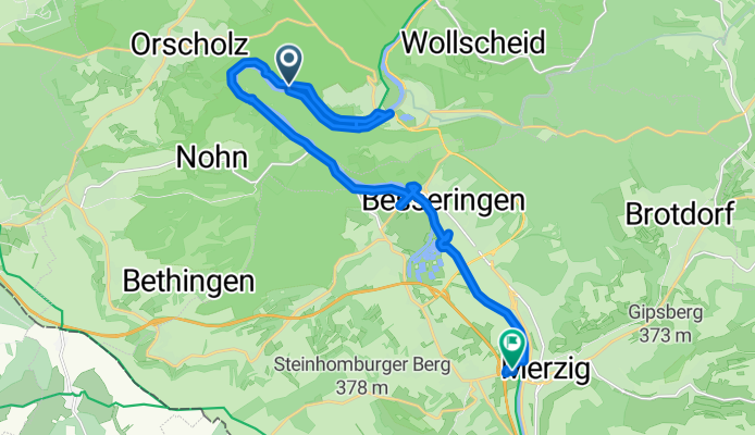
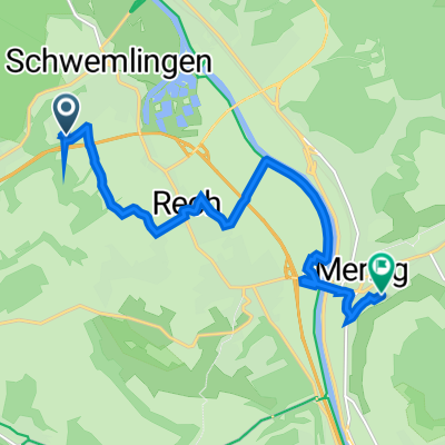
Modèle d’itinéraire
De Mettlach à Merzig

- 1 h 13 min
- Durée
- 17,9 km
- Distance
- 286 m
- Montée
- 277 m
- Descente
- 14,7 km/h
- Vit. moyenne
- 298 m
- Altitude max.
Looking for a scenic spin between two charming Saarland towns? This route from Mettlach to Merzig covers about 18 km and offers a bit of everything—smooth paved stretches, peaceful gravel paths, and the occasional fun climb (with an ascent of almost 290 meters!). Mettlach is famous for the Villeroy & Boch porcelain company and its beautiful Old Abbey, while Merzig welcomes you with cozy cafés and river views.
You'll start in Mettlach, ride out along a patchwork of paved and gravel surfaces, mostly sticking to calm tracks and paths (so you can enjoy the scenery without too much traffic). The ride winds through lush countryside and gently rolling hills—perfect for soaking in the Saar River valley’s greenery.
With a max elevation just shy of 300 meters, you’ll get a couple of gentle uphill sections, but nothing too strenuous. Most of the ride is quiet and away from busy roads, making it ideal if you’re after a relaxed day out. End your journey in Merzig, perhaps with a quick stroll along the Saar or a slice of cake at one of the town’s bakeries!
Communauté
Meilleurs utilisateurs dans cette région


De notre communauté
Les meilleurs itinéraires à vélo de Mettlach à Merzig

Saargau und Bouzonville v Schwemlingen
Itinéraire à vélo à Mettlach, Sarre, Allemagne
- 72,8 km
- Distance
- 555 m
- Montée
- 558 m
- Descente

Fronleichnam 2023
Itinéraire à vélo à Mettlach, Sarre, Allemagne
- 60,1 km
- Distance
- 819 m
- Montée
- 809 m
- Descente
Saarschleife
Itinéraire à vélo à Mettlach, Sarre, Allemagne
- 20,3 km
- Distance
- 268 m
- Montée
- 274 m
- Descente

Saarschleife
Itinéraire à vélo à Mettlach, Sarre, Allemagne
- 20,3 km
- Distance
- 268 m
- Montée
- 274 m
- Descente

schwemlingen chateaux malborough mzg
Itinéraire à vélo à Mettlach, Sarre, Allemagne
- 61,2 km
- Distance
- 700 m
- Montée
- 688 m
- Descente

Britter Straße, Меттлах nach Мерціг
Itinéraire à vélo à Mettlach, Sarre, Allemagne
- 12 km
- Distance
- 166 m
- Montée
- 172 m
- Descente

Mettlach Merzig
Itinéraire à vélo à Mettlach, Sarre, Allemagne
- 14,8 km
- Distance
- 184 m
- Montée
- 187 m
- Descente

Am Wingert 14, Merzig nach Waldstraße 87, Merzig
Itinéraire à vélo à Mettlach, Sarre, Allemagne
- 29 km
- Distance
- 682 m
- Montée
- 673 m
- Descente

Rund ums Saarland_3.Tag
Itinéraire à vélo à Mettlach, Sarre, Allemagne
- 72,4 km
- Distance
- 744 m
- Montée
- 749 m
- Descente

Luxemburg - Karlsruhe, Merzig nach Zum Saargau 3, Merzig
Itinéraire à vélo à Mettlach, Sarre, Allemagne
- 1,4 km
- Distance
- 60 m
- Montée
- 67 m
- Descente
Haardter Weg 30E, Merzig nach Ernst-Thiel-Straße 22, Merzig
Itinéraire à vélo à Mettlach, Sarre, Allemagne
- 9,3 km
- Distance
- 78 m
- Montée
- 118 m
- Descente
Découvrez plus d'itinéraires
 schwemlingen chateaux malborough mzg
- Distance
- 61,2 km
- Montée
- 700 m
- Descente
- 688 m
- Emplacement
- Mettlach, Sarre, Allemagne
 merzig stadt
- Distance
- 5,2 km
- Montée
- 19 m
- Descente
- 75 m
- Emplacement
- Mettlach, Sarre, Allemagne
 Britter Straße, Меттлах nach Мерціг
- Distance
- 12 km
- Montée
- 166 m
- Descente
- 172 m
- Emplacement
- Mettlach, Sarre, Allemagne
 Mettlach Merzig
- Distance
- 14,8 km
- Montée
- 184 m
- Descente
- 187 m
- Emplacement
- Mettlach, Sarre, Allemagne
 Am Wingert 14, Merzig nach Waldstraße 87, Merzig
- Distance
- 29 km
- Montée
- 682 m
- Descente
- 673 m
- Emplacement
- Mettlach, Sarre, Allemagne
 Rund ums Saarland_3.Tag
- Distance
- 72,4 km
- Montée
- 744 m
- Descente
- 749 m
- Emplacement
- Mettlach, Sarre, Allemagne
 Luxemburg - Karlsruhe, Merzig nach Zum Saargau 3, Merzig
- Distance
- 1,4 km
- Montée
- 60 m
- Descente
- 67 m
- Emplacement
- Mettlach, Sarre, Allemagne
 Haardter Weg 30E, Merzig nach Ernst-Thiel-Straße 22, Merzig
- Distance
- 9,3 km
- Montée
- 78 m
- Descente
- 118 m
- Emplacement
- Mettlach, Sarre, Allemagne