
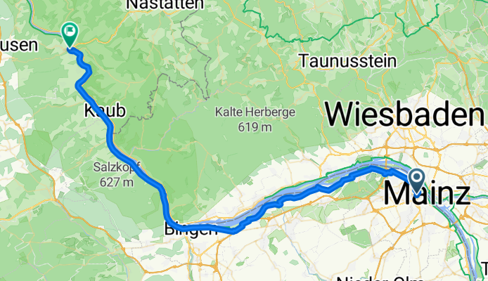
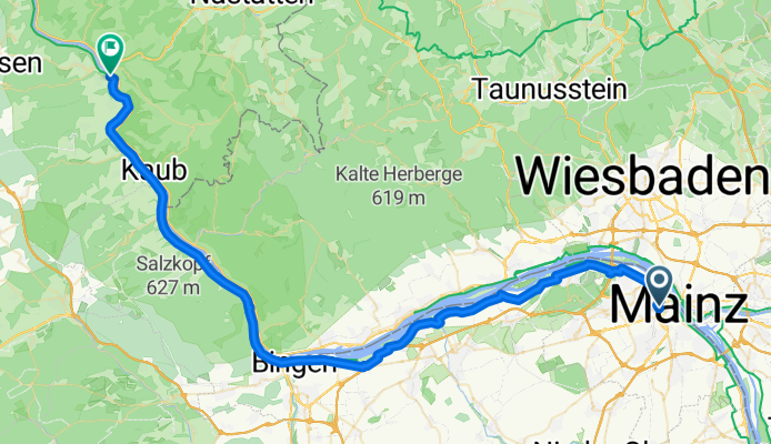
Excursion à vélo d’une journée de Mayence à Sankt Goar
Personnalise ton propre itinéraire à partir de notre modèle ou découvre comment notre communauté préfère rouler de Mayence à Sankt Goar.
Modèle d’itinéraire
De Mayence à Sankt Goar

- 4 h 32 min
- Durée
- 67,2 km
- Distance
- 863 m
- Montée
- 781 m
- Descente
- 14,8 km/h
- Vit. moyenne
- 397 m
- Altitude max.
Get ready for a truly stunning ride from Mainz to Sankt Goar! Starting in Mainz—a vibrant city on the Rhine famous for its beautiful old town and as the home of the Gutenberg press—you’ll pedal north along about 67 kilometers of mostly paved, scenic paths. Expect some climbs along the way; you’ll rack up over 860 meters of ascent as you wind through vineyards, picturesque villages, and rolling hills.
The majority of your route is on paved or asphalt surfaces, often using quiet roads and riverside paths—perfect for relaxing and soaking up the scenery. The highlight is undoubtedly cruising along the UNESCO-listed Upper Middle Rhine Valley, with its legendary castles and dramatic cliffs. Prepare for a few sections with paving stones and short concrete stretches, just to keep things interesting.
You’ll finish in Sankt Goar, a charming Rhine town well-known for the imposing Rheinfels Castle ruins and the famous Loreley rock just across the river—a spot steeped in local legend. This ride offers a blend of culture, history, and breathtaking river views, making it a classic Rhine cycling experience!
Communauté
Meilleurs utilisateurs dans cette région


De notre communauté
Les meilleurs itinéraires à vélo de Mayence à Sankt Goar

Rhein 2016 D5 - Wiesbaden-Sankt Goar
Itinéraire à vélo à Mayence, Rhénanie-Palatinat, Allemagne
- 61,1 km
- Distance
- 209 m
- Montée
- 158 m
- Descente

Rhein-Main-Donau 11
Itinéraire à vélo à Mayence, Rhénanie-Palatinat, Allemagne
- 59,3 km
- Distance
- 211 m
- Montée
- 229 m
- Descente

von Speyer bis Kölln Teil 3 / Mainz-St Goar
Itinéraire à vélo à Mayence, Rhénanie-Palatinat, Allemagne
- 60,9 km
- Distance
- 41 m
- Montée
- 51 m
- Descente

1 Mainz nach St. Goar
Itinéraire à vélo à Mayence, Rhénanie-Palatinat, Allemagne
- 62,6 km
- Distance
- 507 m
- Montée
- 490 m
- Descente

Tag 5 Timon
Itinéraire à vélo à Mayence, Rhénanie-Palatinat, Allemagne
- 61,9 km
- Distance
- 35 m
- Montée
- 48 m
- Descente

Mainz-St. Goar
Itinéraire à vélo à Mayence, Rhénanie-Palatinat, Allemagne
- 64,1 km
- Distance
- 235 m
- Montée
- 249 m
- Descente
Von Mainz bis Sankt Goar
Itinéraire à vélo à Mayence, Rhénanie-Palatinat, Allemagne
- 61,9 km
- Distance
- 547 m
- Montée
- 495 m
- Descente
Bahnhofplatz, Mainz to Heerstraße, Sankt Goar
Itinéraire à vélo à Mayence, Rhénanie-Palatinat, Allemagne
- 60,5 km
- Distance
- 465 m
- Montée
- 478 m
- Descente

Mainz Hbf nach Zum Uhlenhorst 14, Sankt Goar
Itinéraire à vélo à Mayence, Rhénanie-Palatinat, Allemagne
- 63,4 km
- Distance
- 599 m
- Montée
- 474 m
- Descente

MAI-AMD Etappe1
Itinéraire à vélo à Mayence, Rhénanie-Palatinat, Allemagne
- 60,5 km
- Distance
- 231 m
- Montée
- 246 m
- Descente

Tour Franzosenkopf + Mittelrhein
Itinéraire à vélo à Mayence, Rhénanie-Palatinat, Allemagne
- 99,1 km
- Distance
- 1 350 m
- Montée
- 1 358 m
- Descente

Mainradweg 6 Rhein bis zur Loreley 63 km
Itinéraire à vélo à Mayence, Rhénanie-Palatinat, Allemagne
- 63,9 km
- Distance
- 270 m
- Montée
- 141 m
- Descente
Découvrez plus d'itinéraires
 Tag 5 Timon
- Distance
- 61,9 km
- Montée
- 35 m
- Descente
- 48 m
- Emplacement
- Mayence, Rhénanie-Palatinat, Allemagne
 Mainz-St. Goar
- Distance
- 64,1 km
- Montée
- 235 m
- Descente
- 249 m
- Emplacement
- Mayence, Rhénanie-Palatinat, Allemagne
 Von Mainz bis Sankt Goar
- Distance
- 61,9 km
- Montée
- 547 m
- Descente
- 495 m
- Emplacement
- Mayence, Rhénanie-Palatinat, Allemagne
 Bahnhofplatz, Mainz to Heerstraße, Sankt Goar
- Distance
- 60,5 km
- Montée
- 465 m
- Descente
- 478 m
- Emplacement
- Mayence, Rhénanie-Palatinat, Allemagne
 Mainz Hbf nach Zum Uhlenhorst 14, Sankt Goar
- Distance
- 63,4 km
- Montée
- 599 m
- Descente
- 474 m
- Emplacement
- Mayence, Rhénanie-Palatinat, Allemagne
 MAI-AMD Etappe1
- Distance
- 60,5 km
- Montée
- 231 m
- Descente
- 246 m
- Emplacement
- Mayence, Rhénanie-Palatinat, Allemagne
 Tour Franzosenkopf + Mittelrhein
- Distance
- 99,1 km
- Montée
- 1 350 m
- Descente
- 1 358 m
- Emplacement
- Mayence, Rhénanie-Palatinat, Allemagne
 Mainradweg 6 Rhein bis zur Loreley 63 km
- Distance
- 63,9 km
- Montée
- 270 m
- Descente
- 141 m
- Emplacement
- Mayence, Rhénanie-Palatinat, Allemagne
Itinéraires depuis Mayence
Excursion à vélo d’une journée de
Mayence à Francfort-sur-le-Main
Excursion à vélo d’une journée de
Mayence à Worms
Sortie rapide à vélo de
Mayence à Wiesbaden
Sortie rapide à vélo de
Mayence à Klein-Winternheim