À quoi pourrait ressembler le cyclisme dans la Iéna.
À quoi pourrait ressembler le cyclisme dans la Sulza.

Sortie rapide à vélo de Iéna à Sulza

Personnalise ton propre itinéraire à partir de notre modèle ou découvre comment notre communauté préfère rouler de Iéna à Sulza.

Modèle d’itinéraire

De Iéna à Sulza

37 min
Durée
10,3 km
Distance
95 m
Montée
31 m
Descente
16,6 km/h
Vit. moyenne
216 m
Altitude max.

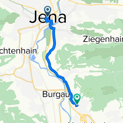
Set off from the lively university city of Jena, known for its historic optical industry and vibrant student scene, and head south towards the tranquil town of Bad Sulza. This 10 km ride is mostly on smooth, paved surfaces, making it ideal for a relaxed outing. As you leave Jena’s urban energy behind, the route quickly transitions into scenic paths and quiet country access roads—perfect for soaking up the rolling fields and gentle Thuringian hills.

The total ascent is manageable, with only about 95 meters to climb, so you’ll get some nice views as you cruise along without burning out your legs. Approaching Sulza, famous for its saltwater spa tradition, you might catch glimpses of the Saale River and picturesque half-timbered houses welcoming you to a peaceful finish.

Expect a mostly comfortable ride—just a few short patches with paving stones or cobblestones to add a bit of character. Whether you’re looking for a leisurely escape or a gentle warm-up before exploring more of the region, this route is a perfect snapshot of Thuringia’s relaxed cycling charm!

Communauté

Meilleurs utilisateurs dans cette région

De notre communauté

Les meilleurs itinéraires à vélo de Iéna à Sulza

Jena Leuchtenburg Stadtroda Jena (am Wehr)
Vélo de route
Paul Teichmann (matrixp)
1

Jena Leuchtenburg Stadtroda Jena (am Wehr)

Itinéraire à vélo à Iéna, Thuringe, Allemagne

Viel Radwege und ruhige Strassen nach der Leuchtenburg. Zum Schluss ausspannen am Wehr mit einem kühlen Blonden.
48,5 km
Distance
334 m
Montée
363 m
Descente
1

Radtour am 9.10.2011 ab 11uhr vom Jenaer Markt

Itinéraire à vélo à Iéna, Thuringe, Allemagne

haupsächlich Feld-, Wald- und Wiesenwege. also geschottert, gewalzt oder staubig-lehmig....
46,8 km
Distance
418 m
Montée
422 m
Descente
1

Fahrradtour am Sonntag den 6.November zur Leuchtenburg

Itinéraire à vélo à Iéna, Thuringe, Allemagne

Falls Interesse besteht zum Mitfahren: Treff am Sonntag um 11Uhr am Markt in Jena...
41,3 km
Distance
331 m
Montée
333 m
Descente
Emil-Wölk-Straße 7 to Philosophenweg Jena
Vélo de ville
0

Emil-Wölk-Straße 7 to Philosophenweg Jena

Itinéraire à vélo à Iéna, Thuringe, Allemagne

This a route for students staying in Studentenwerke Jena and wish to travel to the City center of Jena. The route is very good.
7,7 km
Distance
62 m
Montée
60 m
Descente
Teichweiden Partschefeld
Vélo de route
0

Teichweiden Partschefeld

Itinéraire à vélo à Iéna, Thuringe, Allemagne

Gemütliche einsame Straßen, bis auf das Ende.
91,6 km
Distance
802 m
Montée
769 m
Descente
7

Jenzig - Landgraf - Isserstedt - Jena

Itinéraire à vélo à Iéna, Thuringe, Allemagne

Jenzig - Kunitzburg - Blinkerdenkmal - Landgraf - Napoleonstein - Großschwabhausen - Jena
44 km
Distance
700 m
Montée
696 m
Descente
0

Jena - Stadtroda - Triptis - Pößneck - Kahla - Jena

Itinéraire à vélo à Iéna, Thuringe, Allemagne

85,5 km
Distance
367 m
Montée
360 m
Descente
Jena - Großbockedra - Gernewitz - Ilmnitz - Jena
Vélo de route
0

Jena - Großbockedra - Gernewitz - Ilmnitz - Jena

Itinéraire à vélo à Iéna, Thuringe, Allemagne

26,7 km
Distance
329 m
Montée
324 m
Descente
100km Jena
Vélo de route
1

100km Jena

Itinéraire à vélo à Iéna, Thuringe, Allemagne

98,8 km
Distance
971 m
Montée
924 m
Descente
20160409_155305.gpx
Vélo de route
1

20160409_155305.gpx

Itinéraire à vélo à Iéna, Thuringe, Allemagne

TEASI track
5,7 km
Distance
23 m
Montée
16 m
Descente
0

ruskaring arbeit

Itinéraire à vélo à Iéna, Thuringe, Allemagne

8,2 km
Distance
16 m
Montée
55 m
Descente
0

Jena - Mellingen - Dienstädt - Döllstedt - Rudolstadt - Jena

Itinéraire à vélo à Iéna, Thuringe, Allemagne

Inklusive illegale Durchfahrt Pörzbergtunnel.
105,2 km
Distance
561 m
Montée
570 m
Descente

Découvrez plus d'itinéraires